

VANCOUVER, British Columbia, Aug. 05, 2026 (GLOBE NEWSWIRE) -- Asante Gold Corporation (TSXV: ASE | GSE: ASG | OTCQX: ASGOF) ("Asante" or the "Company") is pleased to announce the filing of updated independently coordinated and prepared NI 43-101 technical reports for its Bibiani and Chirano Gold Mines in Ghana (effective 31 December 2025). These reports supersede the respective technical reports for Bibiani and Chirano filed on 30 April 2024 (effective 31 December 2023). Mineral Resources for both operations have been estimated using a gold price assumption of US$2,500/oz, and Mineral Reserves US$2,100/oz.
HIGHLIGHTS
Consolidated Resource Base
- 4.6 Moz Measured and Indicated ("M&I") Mineral Resources across Bibiani and Chirano (inclusive of Mineral Reserves), in line with December 2023 level despite depletion and production over 430 koz in the aggregate two-year period.
- 1.8 Moz Inferred Mineral Resources across both operations, providing a strong near-term conversion pipeline with active drilling programmes targeting further additions through 2026.
- Both Mineral Resource bases remain open at depth and along strike, with current definition extending to only approximately 300-700m below surface across the +80km Chirano-Bibiani Corridor ("CBC").
- The CBC comprises two principal, parallel Mineralized structures, the Bibiani Shear Zone ("BSZ") and Chirano Shear Zone ("CSZ"), together defining one of West Africa's most prospective yet historically underexplored gold corridors.
Chirano Gold Mine
- 2.53 Moz M&I Mineral Resources (40.01 Mt at 1.96 g/t Au, inclusive of Mineral Reserves) and 830 koz Inferred Mineral Resources (13.8 Mt at 1.87 g/t Au).
- Mineral Reserves of 1.30 Moz (23.69 Mt at 1.71 g/t Au) support a current seven-year Life of Mine plan.
- More than replaced production depletion with an increase of 443 koz in M&I Mineral Resources and 244 koz in Mineral Reserves (relative to December 2023), net of two years of gold mined.
- Approximately 66,900 metres of reverse circulation ("RC") and diamond drilling saw key additions across Obra, Sariehu, Suraw, and Akoti South; validates clear potential of the CSZ, which spans 13 deposits across a ~15 km strike.
- Obra Underground remains the priority depth target along the CSZ, with a north-plunging high-grade shoot that is widening and increasing in grade at depth.
- "North Mine" open pit concept being evaluated across the Obra, Sariehu and Mamnao deposits, with infill drilling successfully demonstrating mineralization between these deposits.
- 2026 drilling targeting further depth and strike extensions at Obra, Suraw, Sariehu, Tano and the Obra-Sariehu gap.
Bibiani Gold Mine
- 2.06 Moz M&I Mineral Resources (30.83 Mt at 2.08 g/t Au, inclusive of Mineral Reserves) and 965 koz Inferred Mineral Resources (16.25 Mt at 1.85 g/t Au).
- Mineral Reserves of 1.53 Moz (23.75 Mt at 2.00 g/t Au) support a current nine-year Life of Mine plan.
- Mineral Reserves and M&I Resources declined 22% and 17% respectively, reflecting open-pit depletion of 111,000 oz, constrained exploration budget relative to Chirano, and model refinements to Main Pit; a revitalised FY2027 drilling programme is planned to rebuild the resource pipeline.
- Approximately 43,000 metres of near-mine RC and diamond infill, extensional and exploration drilling undertaken during 2024-2025 across the Main Pit, Russel South and seven key satellite targets.
- This drilling has confirmed potential for further extensional open pit and underground Mineral Resource definition and mining opportunities at Bibiani.
- Main Pit remains open at depth to at least 1,400m below surface, with North, Central and South Deeps targets planned in 2026-2027 to test depth potential up to 1,600m.
Malik Easah, Chairman of Asante, commented:
"These updated, independently coordinated and prepared technical reports underscore the inherent quality of Asante's geological endowment in the Chirano-Bibiani Corridor, and reinforce the thesis for long-term potential at our Chirano and Bibiani operations. Despite mineral inventory depletion from producing over 430,000 ounces across both mines in the past two years, we have maintained our combined Measured and Indicated Resource base. This is a reassuring reflection of the quality of our near-mine exploration pipeline at both Bibiani and Chirano. At Bibiani specifically, exploration activity was constrained over the 2024-2025 period, however, enhanced exploration budget is planned going forward to rebuild that pipeline. Both assets remain open at depth along the more than 80-kilometre Chirano-Bibiani Corridor, which is largely untested by drilling below 300 to 700 metres depth. At Bibiani in particular, the Main Pit is believed to be open to at least 1,400 metres below surface. This represents significant further upside potential for our future underground mine planning at Bibiani. With a 4.6 million ounce Measured and Indicated Resource base as our foundation, Asante's core focus as a company is to vigorously pursue its ongoing operational improvements at both assets and to thereby translate this geological opportunity into value for shareholders."
GROUP MINERAL RESOURCES - BIBIANI AND CHIRANO - as at 31 December 20251
| M&I Resources (koz) | Inferred Resources (koz) | Mineral Reserves (koz) | |
| Chirano | 2,531 | 830 | 1,303 |
| Bibiani | 2,064 | 965 | 1,527 |
| Group Total | 4,595 | 1,795 | 2,830 |
UNLOCKING VALUE ACROSS THE CHIRANO-BIBIANI CORRIDOR
Asante controls the CBC across +937km2 of combined Bibiani and Chirano tenure, spanning over 80 kilometres of strike along the Sefwi-Bibiani Belt. The Company considers the CBC, which has produced over 8 million ounces of gold over its mining history, to be one of the most prospective yet historically underexplored structural settings in West Africa's Birimian gold province. It is interpreted as an ancient crustal-scale structure that provided the geological conduit responsible for district-scale gold endowment encompassing Bibiani and Chirano. The corridor comprises two principal, sub-parallel structures: the BSZ, which extends across both the Bibiani and southern Chirano tenure, and the CSZ, the main structural control at Chirano.
The Sefwi-Bibiani Belt's structural setting is analogous to other greenstone-hosted gold belts globally, such as the Lefroy-Boulder Fault Zone within Western Australia's Eastern Goldfields (50+ million ounce endowment) and the Abitibi Greenstone Belt in Canada (180+ million ounce endowment), both of which have sustained several mining centres over long production histories along their structural trends. Yet mineralization within the CBC remains largely untested relative to the scale of its broader structural setting. The CBC offers along strike potential both between and beyond the existing mine areas, and is open at depth along its extent, which is largely untested beyond 300 to 700 metres below surface.
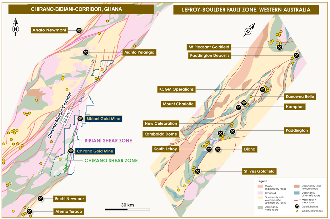
Figure 1. Schematic maps comparing the CBC within the Sefwi Bibiani Gold Belt, Ghana, to the Lefroy-Boulder Fault Zone, showing key gold mines and occurrences.
CHIRANO GOLD MINE - EXPLORATION AND DEVELOPMENT
Chirano comprises thirteen deposits with estimated Mineral Resources across an approximate 15-kilometre strike, associated with the CSZ within the CBC. Since Asante's acquisition of Chirano in August 2022, over 66,900 metres of drilling and 257 holes have delivered significant Mineral Resource and Reserve growth.
Since December 2023, M&I Mineral Resources have grown by 443,000 ounces to 2.53 million ounces (as at 31 December 2025). Mineral Reserves also saw drilling more than replace production depletion (which was approx. 270,000 ounces), with growth in Proven and Probable Mineral Reserves of 244,000 ounces to 1.30 million ounces. This supports a seven-year current Life of Mine plan.
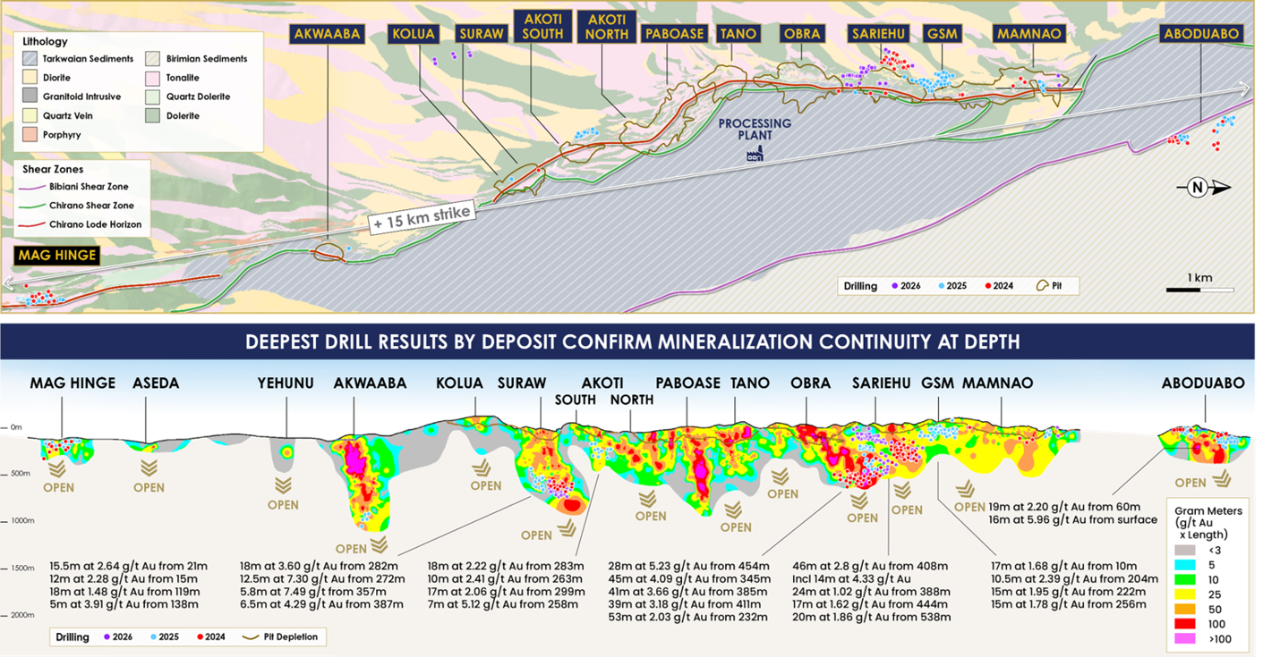
Figure 2. Plan and long section images of the Chirano 2024-25 Mineral Resource and Reserve drilling, highlighting significant Mineralized intercepts and depth potential, along with planned 2026-27 drilling.
Key contributors to the December 2025 Mineral Resource and Reserve additions included:
- Obra Underground: 51 diamond drill holes totalling 18,436 metres contributed 242,000 ounces at 1.50g/t Au to Mineral Reserves, extending the reserve base by 175 metres vertically at depth and confirming a 350 metres strike extension north toward the Sariehu deposit.
- Sariehu: 24 RC diamond drill holes for 13,666 metres tested mineralization below 2,000 metres RL, confirming mineralization at depth and along strike. The programme grew underground Mineral Reserves to over 169,000 ounces at 1.67g/t Au and supported the growth of M&I Resources to 241,600 ounces at 1.85 g/t Au (with production scheduled for 2029).
- Sariehu-Mamnao Gap: 47 RC holes for 8,290 metres successfully closed the gap between the Sariehu and Mamnao deposits, confirming mineralization over 1 kilometre near-surface and supporting a Sariehu Extension M&I Mineral Resource of approximately 118,300 ounces at 0.96 g/t Au.
- Suraw Underground: Drilling totalling 29 diamond holes for 9,650 metres focused on converting Inferred Mineral Resources to Indicated classification between 1,700 and 1,650 metres RL, as well as testing the southern extension of mineralization. The programme added approximately 100,000 ounces at 2.37 g/t Au to M&I Mineral Resources, now totaling 323,000 ounces at 2.52 g/t Au.
- Akoti South: 12 infill holes for 4,102 metres supported extension and resource upgrade drilling, adding approximately 12,000 ounces at 1.66 g/t Au to Mineral Reserves.
- Mag Hinge: 31 holes over 3,369 metres of conversion drilling added 15,600 ounces at 1.15 g/t Au to Mineral Reserves, providing a new source of open-pit material.
Together, Obra, Sariehu, and northern Mamnao form the basis of a "North Mine" concept, which is a plan under evaluation to link mining of all three deposits into one operation. In 2024, drilling successfully closed the Sariehu-Mamnao Gap, confirming continuous mineralization over 1 kilometre near surface between the two deposits and added 73,000 ounces at 1.01 g/t Au the open pit Mineral Reserve base. Significant intercepts included 17m at 1.68 g/t Au from 10m (hole CHRC3495) and 15m at 1.95 g/t Au from 204m (hole CHRC3534).
Additional RC infill drilling was completed at Aboduabo, comprising 45 holes for 5,829 metres, aimed at improving resource confidence and supporting metallurgical test work. Significant intercepts including 19m at 2.20 g/t Au from 60m (hole CHRC3553) and 16.5m at 5.96 g/t Au from surface (CHRC3547).
Across the broader Chirano system, the 13 deposits collectively host 265,000 ounces of open pit M&I Mineral Resources at 1.08 g/t Au and over 2.2 million ounces of underground M&I Mineral Resources at 2.17 g/t Au. Mineralization remains open at depth throughout the system. Mineral Resource definition currently extends to approximately 600 metres below surface, however depth potential is readily demonstrated by Akwaaba, which is developed beyond 800 metres below surface, and Paboase, which was previously mined to approximately 950 metres below surface (at a grade of 3.57 g/t Au). This depth potential remains a key focus of exploration in 2026 and beyond.
2026 CHIRANO EXPLORATION PROGRAMME
Near-mine exploration
Drilling during 2026 directly follows up on the success of results returned in 2024-25, with near-mine drilling underway at Obra, Suraw, Sariehu, and the Obra-Sariehu and Sariehu-Mamnao gaps. Initial results from this drilling continue to support the case for a single, consolidated mining operation across Obra to Mamnao. Additional drilling at Akoti South, Tano and Mamnao is scheduled to commence later in the year, with Mag Hinge to follow in Q4 2026.
At the Obra-Sariehu Gap, drilling is testing near-surface mineralization between the two pits to evaluate open pit potential and support possible pit-linkage opportunities. Year-to-date, 26 RC/RCDD holes totaling 6,015 metres have been completed, confirming mineralization and providing encouraging support for an open-pit pushback assessment. Significant intercepts include 4.2m at 21.21 g/t Au from 324m, including 2.88m at 30.76 g/t Au from 324m (hole CHDD3771UG); and 12.6m at 1.59 g/t Au from 308m, including 9.6m at 1.88 g/t Au from 312m (hole CHRC3775D).
At Sariehu itself, drilling in 2026 aims to build on the existing 241,000 ounce underground M&I Mineral Resource, testing the down-dip extensions of mineralization between 1,850 - 1,900 metres RL, aiming to convert additional Inferred Resources to Indicated category ahead of underground development. Year-to-date, 11 diamond holes totaling 3,136 metres have been completed, with assays returning encouraging results that continue to demonstrate consistent mineralization along strike and at depth, including 20.4m at 1.67 g/t Au from 543.7m, including 2.4m at 2.75 g/t Au from 544m (hole CHRC3772D) and 6.2m at 2.15 g/t Au from 558m, including 3.2m at 3.02 g/t Au from 558m (hole CHRC3772DW1).
Suraw depth extension drilling is underway below 1,650 metres RL, aiming to test the strike and depth potential highlighted by the 2024-25 assay results, where intercepts of 18m at 3.60 g/t Au from 282m (hole CHDD3671UG), including 6.56m at 5.72 g/t Au and 12.5m at 7.30 g/t Au from 272m (hole CHDD3691UG), indicate further extension potential.
Mamnao drilling targeting the northern extension of the deposit is in progress, building on the successful infill/closure of the Sariehu-Mamnao Gap in 2024 and in support of further consolidating the North Mine concept.
At Tano, drilling targets a Mineral Resource upgrade below 1,800 metres RL and extension of mineralization in the western splays.
Drilling at Akoti South is scheduled to commence in Q3 2026, targeting further extension of the maiden Mineral Reserve along strike and at depth.
Mag Hinge drilling is scheduled for Q4 2026, targeting further Mineral Resource definition along strike and at depth in order to advance the near-surface oxide target from Pre-Feasibility Study stage toward eventual Mineral Reserve declaration.
BIBIANI GOLD MINE - EXPLORATION AND DEVELOPMENT
The December 2025 Bibiani Mineral Resource is the result of a systematic near-mine drilling programme during 2024 and 2025 combined with updated geological modelling of the Main Pit. M&I Mineral Resources total 2.06 million ounces, inclusive of Mineral Reserves, with an additional 965,000 ounces of Inferred Mineral Resources. Updated Proven and Probable Mineral Reserves of 1.53 million ounces support a current 9-year Life of Mine plan including both open pit and underground material, with underground development scheduled to commence in late 2026.
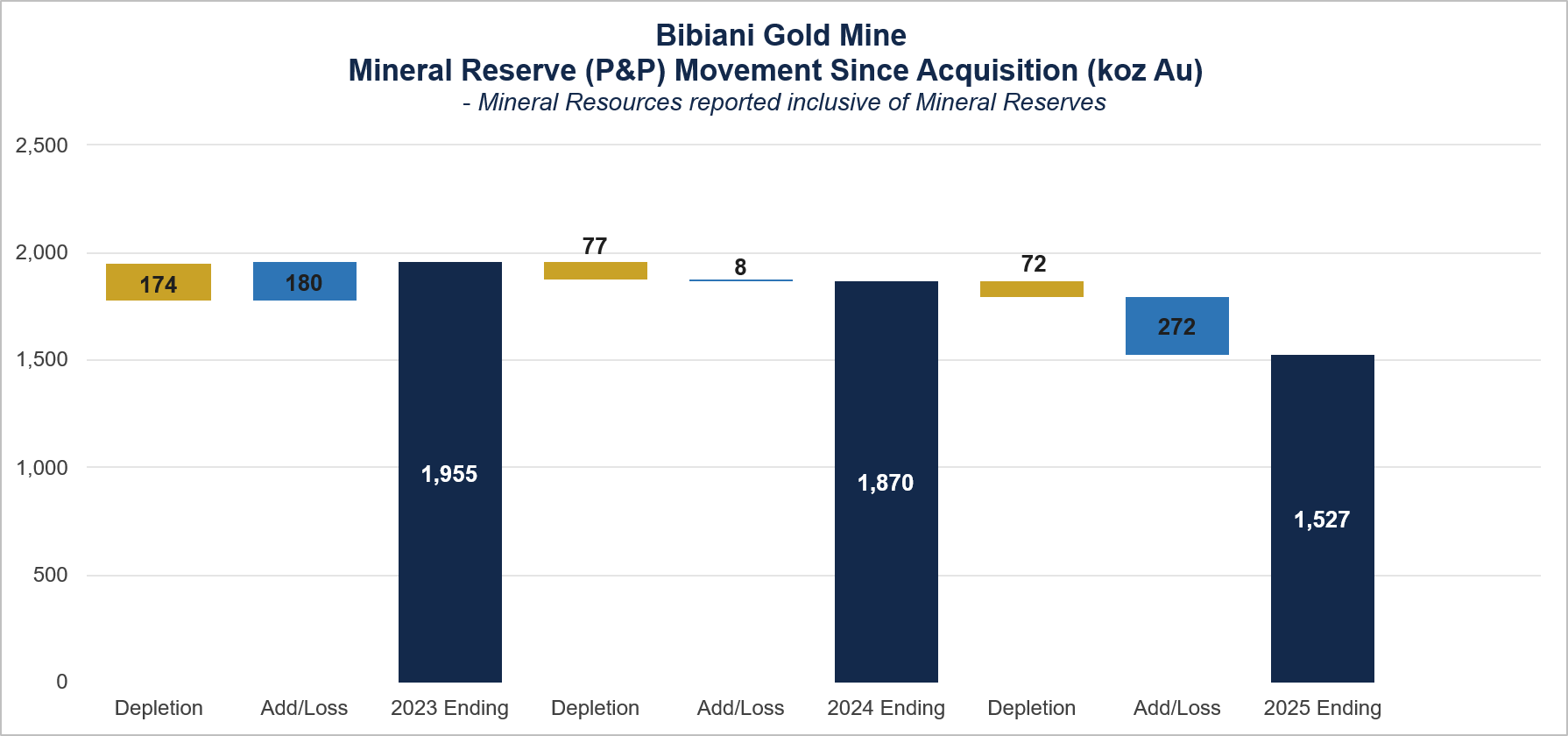
The BSZ hosts a continuous and structurally controlled Mineralized corridor extending from Russel in the south through the Main Pit to Little Mug (now "Cut 6" and an extension of the Main Pit) in the north over 3.7 kilometres of strike - providing the geological framework for Bibiani's near-mine growth strategy. Ongoing Mineral Resource definition and exploration drilling continues to test extensions of this system, both along strike and at depth.
- Approximately 43,000 metres of near mine drilling was completed across the Main Pit and multiple satellite targets during 2024-25. Mineral Resource and Reserve movement during the period reflects mining depletion and exploration open pit additions at Walsh, Russel, Grasshopper and Main Pit (open pit and underground):
- Main Pit / Big Mug: Drilling de-risked the underground Mineral Resource, generating a revised geological model where early reconciliation data shows better representation of the grade distribution.
- Russel South: Approximately 12,500 metres of diamond and RC drilling tested strike and depth extensions, confirming near-surface mineralization 300 metres south of the Russel open pit, and high-grade results at depth.
- Russel Underground: Drilling below the Russel pit shell has confirmed the down-dip extension of a high-grade shoot, supporting a preliminary assessment of underground potential below the current pit shell.
Main Pit
The Main Pit Mineral Resource, incorporating the Big Mug northern extension, now comprises M&I Mineral Resources of approximately 1.93 million ounces (inclusive of Mineral Reserves of 1.53 million ounces) and Inferred Resources of approximately 925,000 ounces. Main Pit has a total Mineralized strike length of approximately 4,000 metres, of which only 1,800 metres has been mined historically, while Mineral Resource definition currently extends to approximately 600 metres below surface. It remains open along strike and at depth, with the NNE-SSW trending and steeply dipping vein system interpreted to continue well below the current base of the defined Mineral Resource.
Approximately 43,000 metres of drilling in 2024-25 were completed at Bibiani, primarily focused on de-risking the Main Pit underground Mineral Resource ahead of underground development. Results supported a revised Mineral Resource evaluation and estimation with enhanced grade distribution, producing a more robust model. Further drilling is warranted ahead of underground mining and is a focus of the 2026 programme.
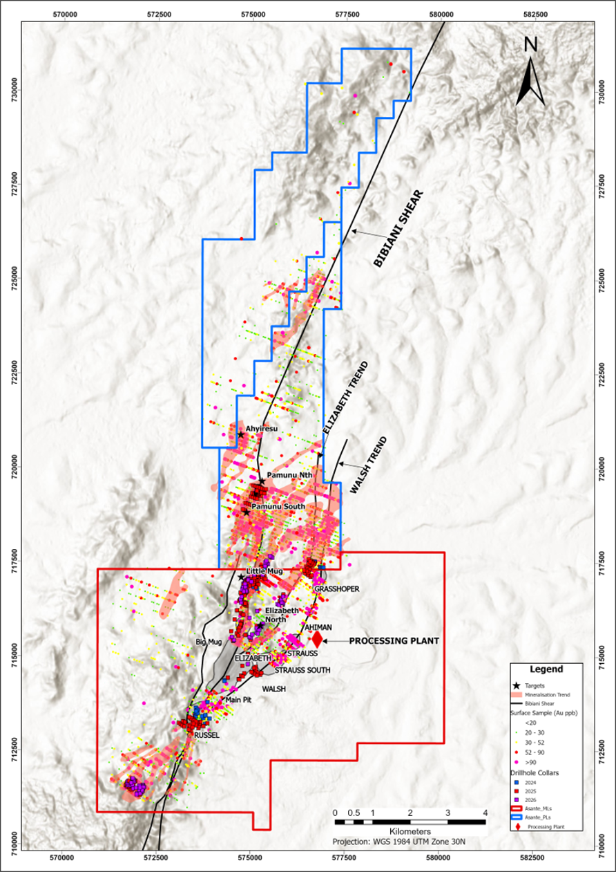
Figure 3. Plan map showing Bibiani operation and drill hole locations from recent 2024 to 2025 Resource drilling programmes and planned 2026 programmes.
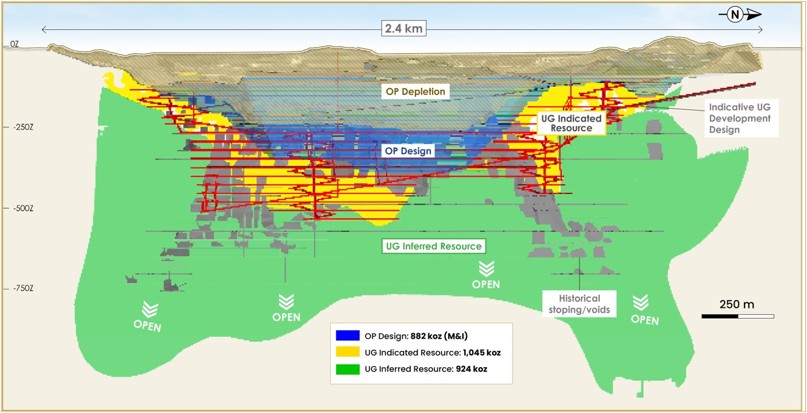
Figure 4. Long-section of Bibiani Main Pit, showing Mineral Resource by category.
At Big Mug, over 7,460 metres of drilling successfully confirmed structural continuity of the Bibiani Main Underground footprint and demonstrated that mineralization remains open at depth. Notable intercepts included:
- 15m at 2.04 g/t Au from 154m (hole MGRCD25-504)
- 7m at 1.79 g/t Au from 179m and 7m at 3.39 g/t Au from 233m (hole MGRCD25-501)
- 13m at 1.37 g/t Au from 195m (hole MGRC25-548)
- 10m at 1.32 g/t Au from 190m and 7m at 2.79 g/t Au from 166m (hole MGRC25-546)
Below the current Main Pit Mineral Resource, three northerly plunging high-grade shoots (North, Central and South Deeps) have been interpreted as down-dip and down-plunge extensions of the Main Pit Mineralized system. Mineralization was recently confirmed to approximately 650 metres below surface and remains open, while high-grade shoots within North and South Deeps were historically stoped to a vertical depth of 850m in the 1920s - 1950s. Based on historical drilling and the Company's current geological interpretation, the system is considered open to at least approximately 1,400 metres below surface.
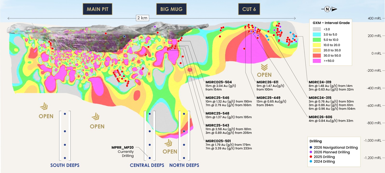
Figure 5. Long-section of the Bibiani Main Pit (now encompassing Big Mug) and Cut 6 extension, showing significant 2024-26 drilling intercepts and interpreted mineralization grade shells (GXM) along the North, Central and South Deeps trends, which remain open at depth.
Russel South and Russel Underground
Exploration continues to investigate the down-dip potential and southern extension of Russel, which commenced producing oxide ore during the period, with 79,000 ounces to date. Approximately 12,500 metres of diamond and RC drilling was completed.
Recent assay results from Russel South, returned discontinuous mineralization along strike at surface, but confirmed an encouraging shallow intercept of 20 metres at 0.94 g/t Au from 145 metres (hole MGRC25-403), located approximately 300 metres south of the existing open pit, supporting potential for a southern open-pit extension.
At depth, drilling also identified a south-plunging zone of mineralization, returning a best intercept of 9 metres at 18.70 g/t Au from 264 metres (hole MGRCD24-308), complementing the previously identified north-plunging "Russel Underground" shoot indicate underground depth potential below the current open pit. This has supported an initial 38,000 ounce Indicated Mineral Resource at "Russel Underground" (2.55 g/t Au), with a further 4,000 ounces classified as Inferred. Significant results include 9.0 metres at 1.68 Au g/t Au from 197metres (hole MGRCD24-307) and 3.0m at 3.49 g/t Au from 237 metres (hole MGRCD24-299) along the south plunging shoot, and 11 metres at 15.81 g/t Au from 260 metres (hole MGRCD24-308), strengthening the north-plunging shoot.
Recent geological interpretation has also suggested that 'the southern extremities of the Main Pit historical underground workings may be structurally connected to the north-easterly plunge of the mineralization at Russel. This potential link is to be tested as underground development of the Main Pit advances.
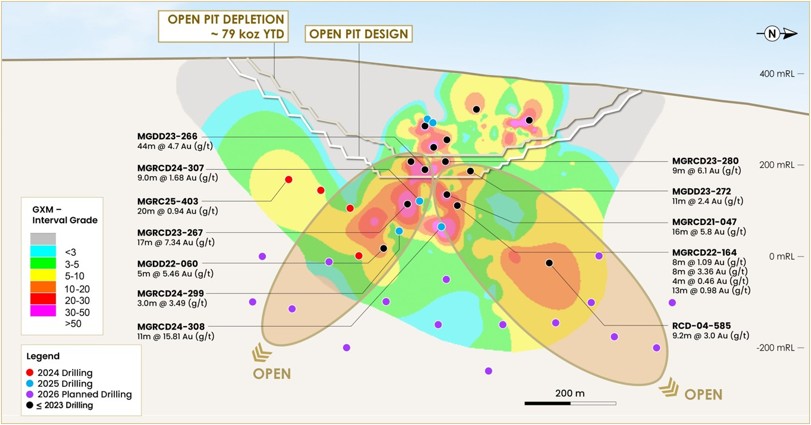
Figure 6. Long-section of Russel Pit showing open pit depletion and design, interpreted GXM grade shells, and pierce points for 2024-25 and planned 2026 drilling, highlighting south and north shoots which remain open at depth.
Advanced exploration was also completed at several near-mine targets with near-surface mineralization, targeting progression towards maiden Mineral Resource status. Further drilling of these targets is planned in 2026 including:
- Cut 6 (Main Pit extension): 82 RC holes totaling 12,600 metres were completed, targeting the strike extension immediately north of Big Mug. Drilling successfully delineating gold mineralization, immediately north of the Bibiani Main Pit, over approximately 1.2 kilometres of strike, and averaging 40 metres below surface. The extension is currently progressing from the Advanced Exploration Stage into the Resource appraisal stage via infill and depth drilling.
- Pamunu: 30 RC holes totalling 3,895 metres followed up historical drill results to enhance confidence in near-surface oxide mineralization, which is being evaluated as a potential future source of open pit material, with internal optimisation studies underway.
- Asempaneye: Initial RC drilling testing three targets (T1, T2, T3) commenced in November 2025 and has intercepted moderate-to-high-grade, near-surface mineralization at T1 and T2 to date.
2026 BIBIANI EXPLORATION PROGRAMME
Near-mine exploration:
Asante's 2026 programme at Bibiani is focused on further conversion drilling of the Main Pit and Big Mug underground Mineral Resources, while advancing several parallel workstreams across near-mine satellite targets and step-out drilling across the BSZ. This work is set to build on the significant results defined in 2025 between the Main Pit and Cut 6 (previously the "Little Mug" prospect) along the BSZ, the Elizabeth North trend, and from the South-West Trend ("SWT") target to Asempaneye.
Approximately 25,685 of 33,250 metres of planned RC and diamond drilling has been completed year-to-date. At the Main Pit, three mother-and-daughter diamond drill holes targeting a central north-plunging shoot beneath the underground Mineral Resource have been completed for a total of 3,307 metres (comprising 298 metres of pre-collared RC drilling and 3,009 metres of diamond drilling). Results were positive, confirming mineralization to approximately 650 metres below surface, which is open at depth. Significant Mineralized intersections include 29.1m at 1.17 g/t Au from 591m (hole MGDD25-550) and 13m at 1.18 g/t Au from 475m (hole MGRCD25-528). Building on this result, a proof-of-concept drilling programme has commenced to test three interpreted Deeps targets - North, Central and South - via 12 navigational diamond drill holes along three drill fences. Drilling along the Central Deeps fence has recently commenced, aiming to test the down plunge extension of mineralization confirmed by the previously mentioned mother-and-daughter holes, with the deepest hole being tested first to a target depth of approximately 1,600 metres.
Additional Mineral Resource definition drilling continues at the Main Pit, aimed at confirming grade continuity, refining geometry, and upgrading Inferred Mineral Resources to Indicated classification. Geological interpretation and 3D modelling remains ongoing, with the new drilling and structural data expected to improve understanding of geometry and continuity, supporting further underground Mineral Resource conversion and growth.
At Russel, infill and depth extension drilling is planned to target underground potential identified below the Russel pit shell, ahead of commencing a formal underground study. At Russel South, follow-up drilling is set to test the down-dip and along-strike near surface mineralization identified approximately 300 metres south of the Russel open pit.
- Cut 6 (Main Pit extension): Resource development drilling is underway in 2026, focused on advancing the southern section of the extension to Indicated Resource category. Approximately 15,000 metres of planned infill and Mineral Resource definition drilling is underway to follow up on near-surface oxide mineralization over a defined strike of approximately 1.2km.
- SWT/ Asempaneye: Step-out drilling south of Russel continues from the SWT target with 13,000 metres of RC drilling planned to test partially drilled geochemical anomalism and the strike extension toward and including Asempaneye.
- Pamunu: Open pit targets are being advanced over 20,000 metres of planned RC drilling, following up on 2025 grade control results to increase confidence in near-surface oxide mineralization.
- Elizabeth Hill: Drilling is scheduled from Q4 2025 to target open-pit potential across an approximate 1 km strike.
Building on the 2026 programme, Asante plans a revitalised and expanded FY2027 exploration budget at Bibiani, targeting increased near-mine drilling metres to rebuild the resource pipeline following the constrained 2024-2025 exploration period. This will focus on further definition and extension drilling across the Main Pit Deeps targets, Cut 6, and the SWT/Asempaneye trend, alongside continued greenfields testing at the Asuontaa and Donkoto licences.
GREENFIELDS EXPLORATION STRATEGY
Beyond near-mine growth described above, Asante is also advancing greenfields exploration across the broader CBC, holding an extensive and largely untested land package comprising 775 km² of prospecting licences around Chirano and further prospective ground across Bibiani's Asuontaa and Donkoto licenses. The Company's greenfields strategy is to systematically screen its tenure through regional surface mapping, geochemistry and geophysics, building a ranked and risked pipeline of first pass drill targets to test, while progressing the highest priority zones toward maiden Mineral Resource status over time.
At Chirano, drill pad preparation is underway at the Anansu Prospecting License following up encouraging near-surface mapping and trenching at the Nyama Yama and DBS targets, with first-pass drilling planned in Q4 2026 at Futa South and, further north, at Aso-Meko, Chine and the Aboduabo extension/Zone 3A. At Bibiani, field mapping and grab sampling completed in 2025 confirmed gold mineralization in granitoids and quartz veins at the Yaro and Bredi targets within the Asuontaa license, with follow-up drill testing planned into 2027.
Given the scale and historically underexplored nature of the CBC, which Asante considers comparable to prolific greenstone belts such as the Lefroy-Boulder Fault Zone of Western Australia and Abitibi Greenstone Belt in North America, the Company views greenfields exploration as a multi-year and corridor-wide opportunity to define new mining operations beyond the existing Bibiani and Chirano operations.
QUALITY ASSURANCE / QUALITY CONTROL
The 2026 drilling program was conducted in accordance with industry best practices and followed drilling, sampling, QA/QC and data management procedures previously implemented at Chirano. These procedures have been reviewed and validated by the Asante Gold Exploration team and various external Qualified Persons and are consistent with accepted industry standards.
Asante employs a QA/QC program consistent with industry best practices. Drilling was conducted by GTS Drilling Services, Deep Rock Drilling and Toomahit Drilling and was supervised by the Asante exploration teams. Selected drill core intervals were cut in half with a diamond blade saw. Half of the sampled core was left in the core box and the remaining half was bagged and sealed. Asante utilizes accredited laboratories, and the samples were transported to either ALS-Kumasi or the Intertek laboratory in Tarkwa, Ghana. Gold was analyzed by 50-gram fire assay with Atomic Absorption-finish. Certified reference material (CRM) standards, duplicates, and coarse blank material are inserted. Results from the QA/QC program indicate that assay quality is within acceptable limits and supports the reliability of the analytical data.
ABOUT THE TECHNICAL REPORTS
The updated technical reports, entitled "NI 43-101 Technical Report and Updated Mineral Resource Estimate, Asante Gold Bibiani Limited, Ghana, West Africa" and "NI 43-101 Technical Report and Updated Mineral Resource Estimate, Asante Gold Chirano Limited, Ghana, West Africa", each with an effective date of 31 December 2025 and an issue date of 5 August 2026, have been prepared in accordance with National Instrument 43-101, Standards of Disclosure for Mineral Projects ("NI 43-101"), and filed under the Company's SEDAR+ profile at www.sedarplus.ca. The reports supersede the prior technical reports for Bibiani and Chirano filed on 30 April 2024. Readers are encouraged to read the technical reports in their entirety, including all qualifications, assumptions and risks, available on SEDAR+ and the Company's website at www.asantegold.com.
QUALIFIED PERSONS STATEMENT
The scientific and technical information in this news release has been reviewed and approved by Dean Bertram, Vice President Geology of Asante Gold Corporation, a Qualified Person as defined by NI 43-101.The updated technical reports were prepared by the following independent Qualified Persons: David Michael Begg of dMb Management Services Pty Ltd; Clive Brown and Galen White of Bara Consulting Limited; and Glenn Bezuidenhout of GB Independent Consulting Pty Ltd. Each Qualified Person has reviewed and approved the portions of the technical reports relevant to their area of responsibility. None of the independent Qualified Persons hold any interest in Asante, its associated parties, or in any of the mineral properties which are the subject of this news release.
NON-IFRS MEASURES
This news release includes certain terms or performance measures commonly used in the mining industry that are not defined under International Financial Reporting Standards ("IFRS"), including "life of mine". Non-IFRS measures do not have any standardized meaning prescribed under IFRS and may not be comparable to similar measures employed by other companies. The data is intended to provide additional information and should not be considered in isolation or as a substitute for measures prepared in accordance with IFRS.
ABOUT ASANTE GOLD CORPORATION
Asante is a growing mid-tier gold producer, developer and explorer with a high-quality portfolio of assets located on two of West Africa's most prolific and prospective gold belts in Ghana. The Company operates the Bibiani and Chirano Gold Mines on the Sefwi-Bibiani Gold Belt in Ghana's Western North Region, where it holds an extensive and underexplored land position spanning more than 80 kilometres of strike. Asante is also advancing its Kubi Gold Project on the Ashanti Gold Belt, extending the Company's footprint across Ghana's most productive gold corridor. Committed to responsible mining and the creation of lasting value for its shareholders, people and host communities, Asante is listed on the TSX Venture Exchange, the Ghana Stock Exchange, and the OTCQX Market in the United States. Additional information is available on the Company's website at www.asantegold.com.
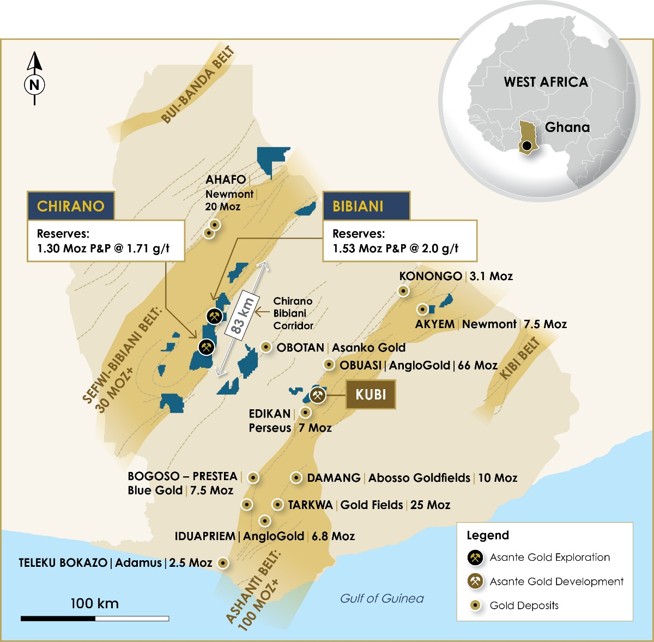
Figure 7. Asante Portfolio, Ghana.
About The Bibiani Gold Mine
Bibiani is an operating open pit gold mine situated in the Western North Region of Ghana, with historical gold production of more than 4.5 million ounces. The mine is fully permitted with mining and processing infrastructure on-site, including a refurbished process plant and associated mining infrastructure. Asante commenced mining at Bibiani in late February 2022, with commercial production announced on 10 November 2022.
About The Chirano Gold Mine
Chirano is an operating open pit and underground mine located in the Western Region of Ghana. The mine was first explored and developed in 1996 and began production in October 2005. Chirano comprises multiple open pit and underground operations and has produced over 3 million ounces of gold. Asante acquired its 90% interest in Chirano in August 2022.
CAUTIONARY NOTE REGARDING FORWARD-LOOKING STATEMENTS
Certain statements in this news release constitute forward-looking statements or forward-looking information. All statements, other than statements of historical fact, are forward-looking statements or information. Forward-looking statements or information in this news release relate to, among other things: mineral resource and mineral reserve estimates; life of mine; future exploration plans and strategies; growth strategies at Bibiani and Chirano; and planned production. These forward-looking statements and information reflect the Company's current views with respect to future events and are necessarily based upon a number of assumptions that, while considered reasonable by the Company, are inherently subject to significant operational, business, economic and regulatory uncertainties and contingencies. These assumptions include: the impact of inflation and disruptions to the global, regional and local supply chains; tonnage of mineralized material to be mined and processed; future anticipated prices for gold and assumed foreign exchange rates; the timing and impact of planned capital expenditure projects, including anticipated sustaining, project, and exploration expenditures; risks related to increased barriers to trade, including tariffs and duties; grades and recoveries; capital, decommissioning and reclamation estimates; mineral reserve and mineral resource estimates and the assumptions upon which they are based; prices for energy inputs, labour, materials, supplies and services (including transportation); no labour-related disruptions at any of the Company's operations; no unplanned delays or interruptions in scheduled development and/or production; all necessary permits, licenses and regulatory approvals for the Company's operations are received in a timely manner; the Company's ability to secure and maintain title and ownership to mineral properties and the surface rights necessary for its operations, including contractual rights from third parties and adjacent property owners; whether the Company is able to maintain a strong financial condition and have sufficient capital, or have access to capital, to sustain its business and operations; and the Company's ability to comply with environmental, health and safety laws. The foregoing list of assumptions is not exhaustive.
Forward-looking statements involve risks, uncertainties and other factors that could cause actual results, performance, prospects, and opportunities to differ materially from those expressed or implied by such forward-looking statements. Factors that could cause actual results to differ materially from these forward-looking statements include, but are not limited to, the duration and effect of local and world-wide inflationary pressures and the potential for economic recessions; fluctuations in the price of gold; fluctuations in currency markets; operational risks and hazards inherent with the business of mining (including environmental accidents and hazards, industrial accidents, equipment breakdown, unusual or unexpected geological or structural formations, cave-ins, flooding and severe weather); risks relating to the credit worthiness or financial condition of suppliers, refiners and other parties with whom the Company does business; inadequate insurance, or inability to obtain insurance, to cover these risks and hazards; employee relations; relationships and claims by local communities; changes in laws, regulations and government practices in the jurisdictions where we operate, including environmental, export and import laws and regulations; changes in national and local government, legislation, taxation, controls or regulations and political, legal or economic developments in countries where the Company may carry on business, including legal restrictions relating to mining, risks relating to expropriation; variations in the nature, quality and quantity of any mineral deposits that may be located, the Company's inability to obtain any necessary permits, consents or authorizations required for its planned activities, the Company's inability to raise the necessary capital or to be fully able to implement its business and growth strategies, and those risk factors identified in the Company's management's discussions and analysis and the most recent annual information form. The reader is referred to the Company's public disclosure record which is available on SEDAR+ (www.sedarplus.ca). Although the Company believes that the assumptions and factors used in preparing the forward-looking statements are reasonable, undue reliance should not be placed on these statements, which only apply as of the date of this news release, and no assurance can be given that such events will occur in the disclosed time frames or at all. Except as required by securities laws and the policies of the securities exchanges on which the Company is listed, the Company disclaims any intention or obligation to update or revise any forward-looking statement, whether as a result of new information, future events or otherwise.
Contact Information
Fred Attakumah - Executive Vice President and Country Manager
investor@asantegold.com
+1 604 661 9400 or +233 303 972 147
APPENDIX A: MINERAL RESOURCE ESTIMATES AND RESERVE ESTIMATES
The Mineral Resource and Reserve estimates are reported in accordance with the requirements and guidelines of NI 43-101 (small discrepancies may occur due to the effect of rounding).
Mineral Resource Estimates
Mineral Resources are not Mineral Reserves. The Mineral Resources are reported inclusive of Mineral Reserves that may be derived from them. Tonnes have been rounded to the nearest 10,000t and ounces to the nearest 1,000oz to reflect these as estimates.
Table 1: Bibiani Gold Mine - Total Mineral Resource Inventory as at 31 December 2025
| Classification | Tonnes (Mt) | Grade (g/t Au) | Gold (koz) |
| Measured | 0.12 | 1.35 | 5 |
| Indicated | 30.71 | 2.09 | 2,059 |
| Measured + Indicated | 30.83 | 2.08 | 2,064 |
| Inferred | 16.25 | 1.85 | 965 |
- Mineral Resources are reported inclusive of Mineral Reserves.
- Mineral Resources are not Mineral Reserves and do not have demonstrated economic viability.
- Tonnes and ounces have been rounded and this may result in minor discrepancies.
- Open Pit Mineral Resources have been reported above a cut-off grade of 0.36g/t Au, constrained within a conceptual pit shell using a US$2,500/oz gold price to satisfy reasonable prospects of eventual economic extraction ("RPEEE").
- Underground Mineral Resources have been reported using a cut-off grade of 0.66g/t Au (Main Pit and Russel) and 0.81g/t Au (Walsh/Strauss), within conceptual mineable shape optimization ("MSO") shapes using a US$2,500/oz gold price to satisfy RPEEE.
- Inferred Mineral Resources have a lower level of confidence than that applying to Indicated Mineral Resources and have not been converted to Mineral Reserves. It is reasonably expected that the majority of Inferred Mineral Resources could be upgraded to Indicated Mineral Resources with continued exploration.
Table 2: Chirano Gold Mine - Total Mineral Resource Inventory as at 31 December 2025
| Classification | Tonnes (Mt) | Grade (g/t Au) | Gold (koz) |
| Measured | 12.40 | 2.07 | 827 |
| Indicated | 27.70 | 1.91 | 1.703 |
| Measured + Indicated | 40.01 | 1.96 | 2,531 |
| Inferred | 13.80 | 1.87 | 830 |
- Mineral Resource Estimate expressed on a 100% basis; Asante owns 90% of the Chirano Mine.
- Mineral Resources are reported inclusive of Mineral Reserves.
- Mineral Resources are not Mineral Reserves and do not have demonstrated economic viability.
- Tonnes and ounces have been rounded and this may result in minor discrepancies.
- Open Pit Mineral Resources have been reported using a cut-off grade of 0.40g/t Au, constrained within a conceptual pit shell using a US$2,500/oz gold price to satisfy RPEEE.
- Underground Mineral Resources have been reported using deposit-specific cut-off grades ranging from 1.08g/t Au to 1.25g/t Au, within conceptual MSO shapes using a US$2,500/oz gold price to satisfy RPEEE.
- Inferred Mineral Resources have a lower level of confidence than that applying to Indicated Mineral Resources and have not been converted to Mineral Reserves. It is reasonably expected that the majority of Inferred Mineral Resources could be upgraded to Indicated Mineral Resources with continued exploration.
Mineral Reserve Estimates
Table 3: Bibiani Gold Mine - Mineral Reserve Estimate as at 31 December 2025
| Classification | Tonnes (Mt) | Grade (g/t Au) | Gold (koz) |
| Proven | 0.14 | 0.93 | 4 |
| Probable | 23.61 | 2.01 | 1,523 |
| Total Proven and Probable | 23.75 | 2.00 | 1,527 |
- Mineral Reserves reported in accordance with NI 43-101.
- Mineral Reserves are estimated using a gold price of US$2,100/oz.
- Tonnes and ounces have been rounded and this may result in minor discrepancies.
- Life of Mine of nine years, including open pit and underground operations.
- The Mineral Reserve estimates contained herein may be subject to legal, political, environmental or other risks that could materially affect the potential exploitation of such Mineral Reserves.
Table 4: Chirano Gold Mine - Mineral Reserve Estimate as at 31 December 2025
| Classification | Tonnes (Mt) | Grade (g/t Au) | Gold (koz) |
| Proven | 5.88 | 1.53 | 289 |
| Probable | 17.81 | 1.77 | 1,014 |
| Total Proven and Probable | 23.69 | 1.71 | 1,303 |
- Mineral Reserves reported in accordance with NI 43-101.
- Mineral Reserve Estimate expressed on a 100% basis; Asante owns 90% of the Chirano Mine.
- Mineral Reserves are estimated using a gold price of US$2,100/oz.
- Tonnes and ounces have been rounded and this may result in minor discrepancies.
- Life of Mine of seven years, including open pit and underground operations.
- The Mineral Reserve estimates contained herein may be subject to legal, political, environmental or other risks that could materially affect the potential exploitation of such Mineral Reserves.
APPENDIX B:
Chirano Drill Program - Collar Details
Table 5: Sariehu Extension - 2024/25 Surface Drilling Collar Positions
| Mineralized Deposit | Hole ID | North (Local Grid) | East (Local Grid) | Elevation (Local Grid) | Depth (m) | Azimuth TN | Dip (°) | Hole Type |
| SARIEHU EXTENSION 2024-2025 | CHRC3467 | 38824.79 | 14947.86 | 2493.64 | 257.00 | 89.5 | -55.7 | RC |
| CHRC3469 | 38837.46 | 14980.18 | 2490.63 | 175.00 | 89.1 | -46.5 | RC | |
| CHRC3470 | 38900.00 | 14949.16 | 2495.48 | 260.00 | 87.3 | -60.0 | RC | |
| CHRC3471 | 38983.15 | 15035.43 | 2452.91 | 103.00 | 86.6 | -45.0 | RC | |
| CHRC3472 | 38982.75 | 15034.54 | 2452.95 | 134.00 | 90.0 | -62.0 | RC | |
| CHRC3473 | 38950.21 | 15070.25 | 2442.12 | 65.00 | 87.9 | -52.1 | RC | |
| CHRC3474 | 39054.40 | 14967.13 | 2482.15 | 230.00 | 88.8 | -52.0 | RC | |
| CHRC3476 | 39027.43 | 14997.23 | 2465.08 | 150.00 | 87.0 | -45.0 | RC | |
| CHRC3477 | 39081.96 | 14971.72 | 2493.74 | 190.00 | 88.6 | -46.0 | RC | |
| CHRC3478 | 38946.67 | 14979.37 | 2479.50 | 190.00 | 87.7 | -52.8 | RC | |
| CHRC3479 | 38946.79 | 14978.59 | 2479.49 | 214.00 | 86.8 | -62.2 | RC | |
| CHRC3480 | 38858.73 | 14941.73 | 2498.87 | 320.00 | 85.5 | -63.0 | RC | |
| CHRC3481 | 38870.69 | 14947.57 | 2498.29 | 217.00 | 89.0 | -44.5 | RC | |
| CHRC3482 | 38870.93 | 14944.70 | 2498.39 | 259.00 | 83.6 | -55.2 | RC | |
| CHRC3484 | 39000.88 | 15019.90 | 2457.21 | 163.00 | 87.6 | -67.5 | RC | |
| CHRC3485 | 39027.99 | 14990.90 | 2465.34 | 187.00 | 86.5 | -60.5 | RC | |
| CHRC3486 | 38969.71 | 15073.91 | 2445.27 | 60.00 | 90.0 | -44.4 | RC | |
| CHRC3487 | 39083.62 | 14967.06 | 2493.67 | 235.00 | 86.0 | -59.0 | RC | |
| CHRC3489 | 38924.83 | 15035.50 | 2463.09 | 100.00 | 88.8 | -58.5 | RC | |
| CHRC3490 | 38924.75 | 15033.77 | 2463.08 | 127.00 | 88.8 | -58.5 | RC | |
| CHRC3491 | 39054.50 | 14965.74 | 2481.81 | 254.00 | 89.0 | -64.0 | RC | |
| CHRC3494 | 39125.23 | 14909.23 | 2505.21 | 260.00 | 86.8 | -45.3 | RC | |
| CHRC3495 | 39125.11 | 14908.18 | 2505.24 | 280.00 | 86.8 | -52.0 | RC | |
| CHRC3507 | 39099.66 | 14901.53 | 2497.51 | 50.00 | 90.0 | -46.2 | RC | |
| CHRC3508 | 39099.77 | 14899.55 | 2497.42 | 58.00 | 89.7 | -67.1 | RC | |
| CHRC3509 | 39075.04 | 14874.03 | 2496.46 | 67.00 | 89.6 | -45.2 | RC | |
| CHRC3510 | 39024.86 | 14869.92 | 2481.44 | 37.00 | 90.1 | -50.0 | RC | |
| CHRC3511 | 39045.71 | 14871.86 | 2484.96 | 38.00 | 90.0 | -60.0 | RC | |
| CHRC3512 | 39124.75 | 14880.25 | 2508.63 | 71.00 | 90.0 | -55.0 | RC | |
| CHRC3513 | 39124.98 | 14948.91 | 2505.02 | 217.00 | 88.0 | -45.0 | RC | |
| CHRC3515 | 39148.88 | 14867.56 | 2512.98 | 320.00 | 85.0 | -51.1 | RC | |
| CHRC3516 | 39174.07 | 14893.64 | 2490.02 | 70.00 | 85.0 | -54.0 | RC | |
| CHRC3517 | 39223.45 | 14889.59 | 2472.66 | 70.00 | 84.8 | -53.0 | RC | |
| CHRC3518 | 38865.23 | 14944.09 | 2498.44 | 253.00 | 91.9 | -57.0 | RC | |
| CHRC3520D | 38915.05 | 14955.23 | 2491.29 | 237.20 | 88.0 | -57.0 | RC | |
| CHRC3521 | 39116.18 | 14856.05 | 2511.75 | 100.00 | 88.5 | -49.1 | RC | |
| CHRC3522 | 39175.24 | 14984.99 | 2490.79 | 175.00 | 88.4 | -46.1 | RC | |
| CHRC3523 | 39175.27 | 14982.20 | 2490.88 | 211.00 | 88.8 | -58.0 | RC | |
| CHRC3525 | 39149.55 | 14991.28 | 2491.00 | 180.00 | 87.3 | -54.1 | RC | |
| CHRC3526 | 39125.02 | 14994.21 | 2490.89 | 163.00 | 86.8 | -47.0 | RC | |
| CHRC3527 | 39082.61 | 14997.12 | 2489.88 | 157.00 | 89.0 | -45.0 | RC | |
| CHRC3528 | 38874.91 | 14999.64 | 2489.12 | 157.00 | 89.9 | -45.0 | RC | |
| CHRC3529 | 38775.56 | 14958.75 | 2481.62 | 217.00 | 90.0 | -45.0 | RC | |
| CHRC3531 | 38775.50 | 14956.80 | 2481.73 | 254.00 | 88.0 | -55.0 | RC | |
| CHRC3532 | 39140.85 | 14905.59 | 2503.72 | 271.00 | 87.6 | -45.0 | RC | |
| CHRC3533 | 38725.00 | 14947.44 | 2469.54 | 234.00 | 87.6 | -45.0 | RC | |
| CHRC3534 | 38724.73 | 14945.30 | 2469.61 | 253.00 | 90.0 | -54.0 | RC |
Table 6: Mamnao North - 2024/25 Surface Drilling Collar Positions
| Mineralized Deposit | Hole ID | North (Local Grid) | East (Local Grid) | Elevation (Local Grid) | Depth (m) | Azimuth TN | Dip (°) | Hole Type |
| MAMNAO NORTH 2024-2025 | CHRC3570 | 40350.01 | 14995.12 | 2362.05 | 140.00 | 89.8 | -61.0 | RC |
| CHRC3571 | 40350.16 | 15027.58 | 2361.77 | 100.00 | 89.9 | -48.0 | RC | |
| CHRC3572 | 40350.01 | 15063.73 | 2361.27 | 109.00 | 89.7 | -45.1 | RC | |
| CHRC3573 | 40324.99 | 14981.91 | 2362.53 | 160.00 | 89.6 | -56.0 | RC | |
| CHRC3574 | 40300.12 | 14967.35 | 2362.49 | 200.00 | 89.7 | -45.0 | RC | |
| CHRC3575 | 40325.28 | 15027.51 | 2361.98 | 121.00 | 89.5 | -45.0 | RC | |
| CHRC3577 | 40349.55 | 15011.68 | 2361.83 | 145.00 | 89.9 | -55.0 | RC |
Table 7: Aboduabo - 2024/25 Surface Drilling Collar Positions
| Mineralized Deposit | Hole ID | North (Local Grid) | East (Local Grid) | Elevation (Local Grid) | Depth (m) | Azimuth TN | Dip (°) | Hole Type |
| ABODUABO 2024-2025 | CHRC3536 | 42606.76 | 15441.74 | 2314.31 | 300.00 | 72.0 | -45.0 | RC |
| CHRC3537 | 42601.63 | 15407.38 | 2317.21 | 270.00 | 72.6 | -45.1 | RC | |
| CHRC3538 | 42675.11 | 15424.01 | 2277.70 | 120.00 | 74.6 | -45.0 | RC | |
| CHRC3539 | 42639.49 | 15432.37 | 2295.03 | 130.00 | 75.0 | -45.0 | RC | |
| CHRC3540 | 42528.56 | 15494.07 | 2307.36 | 140.00 | 91.0 | -45.0 | RC | |
| CHRC3541 | 42528.56 | 15492.94 | 2307.40 | 170.00 | 91.0 | -54.9 | RC | |
| CHRC3542 | 42559.04 | 15492.26 | 2306.44 | 211.00 | 91.0 | -47.0 | RC | |
| CHRC3543 | 42559.00 | 15494.41 | 2306.20 | 140.00 | 91.0 | -57.0 | RC | |
| CHRC3544 | 42576.00 | 15495.84 | 2306.32 | 229.00 | 83.0 | -50.0 | RC | |
| CHRC3545 | 42506.70 | 15570.10 | 2291.76 | 80.00 | 250.0 | -45.0 | RC | |
| CHRC3546 | 42475.13 | 15560.20 | 2292.83 | 37.00 | 270.0 | -45.0 | RC | |
| CHRC3547 | 42472.87 | 15571.68 | 2293.15 | 120.00 | 85.0 | -45.0 | RC | |
| CHRC3548 | 42702.80 | 15412.28 | 2262.73 | 79.00 | 74.9 | -45.0 | RC | |
| CHRC3549 | 42702.42 | 15410.91 | 2262.94 | 107.00 | 74.8 | -58.0 | RC | |
| CHRC3550 | 42074.19 | 15677.19 | 2390.26 | 123.00 | 265.2 | -48.0 | RC | |
| CHRC3551 | 42125.14 | 15640.75 | 2410.63 | 169.00 | 89.8 | -45.0 | RC | |
| CHRC3552 | 42125.74 | 15638.25 | 2410.74 | 229.00 | 81.7 | -71.9 | RC | |
| CHRC3553 | 42099.88 | 15642.91 | 2411.21 | 160.00 | 89.9 | -55.0 | RC | |
| CHRC3554 | 42025.68 | 15656.54 | 2397.62 | 109.00 | 93.9 | -54.0 | RC | |
| CHRC3555 | 42054.96 | 15628.74 | 2402.59 | 106.00 | 84.9 | -50.0 | RC | |
| CHRC3556 | 42679.66 | 15465.97 | 2274.11 | 133.00 | 269.9 | -45.0 | RC | |
| CHRC3557 | 42679.61 | 15487.58 | 2273.50 | 157.00 | 269.5 | -46.1 | RC | |
| CHRC3559 | 42575.15 | 15447.20 | 2324.45 | 170.00 | 89.7 | -51.0 | RC | |
| CHRC3560 | 42580.55 | 15445.41 | 2324.42 | 133.00 | 74.7 | -45.0 | RC | |
| CHRC3561 | 42502.88 | 15578.88 | 2291.91 | 127.00 | 95.0 | -45.0 | RC |
Table 8: Akwaaba - 2024/25 Underground Drilling Collar Positions
| Mineralized Deposit | Hole ID | North (Local Grid) | East (Local Grid) | Elevation (Local Grid) | Depth (m) | Azimuth TN | Dip (°) | Hole Type |
| AKWAABA 2024-2025 | CHDD3620UG | 31762.09 | 17000.26 | 1432.88 | 299.90 | 265.1 | -47.1 | DD |
| CHDD3622UG | 31761.63 | 16999.96 | 1432.90 | 276.20 | 256.9 | -35.6 | DD | |
| CHDD3624UG | 31761.45 | 17000.41 | 1432.84 | 322.40 | 248.2 | -46.9 | DD | |
| CHDD3625UG | 31761.53 | 17000.54 | 1432.75 | 413.50 | 249.6 | -51.9 | DD |
Table 9: Akoti South - 2024/25 Surface Drilling Collar Positions
| Mineralized Deposit | Hole ID | North (Local Grid) | East (Local Grid) | Elevation (Local Grid) | Depth (m) | Azimuth TN | Dip (°) | Hole Type |
| AKOTI SOUTH 2024-2025 | CHRC3563D | 34628.52 | 15614.24 | 2361.14 | 306.00 | 91.7 | -57.0 | RCDD |
| CHRC3566D | 34776.89 | 15574.31 | 2339.16 | 298.65 | 85.6 | -54.2 | RCDD | |
| CHRC3568 | 34579.85 | 15634.64 | 2361.22 | 271.00 | 91.5 | -50.0 | RC | |
| CHRC3578D | 34674.23 | 15590.35 | 2355.33 | 321.60 | 89.9 | -55.0 | RCDD | |
| CHRC3579D | 34674.34 | 15588.59 | 2355.39 | 360.00 | 89.6 | -60.0 | RCDD | |
| CHRC3581D | 34653.87 | 15614.83 | 2357.95 | 315.20 | 88.4 | -58.2 | RCDD | |
| CHRC3583D | 34773.36 | 15548.71 | 2342.00 | 398.30 | 87.8 | -62.1 | RCDD | |
| CHRC3586D | 34702.39 | 15585.35 | 2352.81 | 396.20 | 89.2 | -57.7 | RCDD | |
| CHRC3589D | 34829.88 | 15587.41 | 2321.56 | 285.15 | 93.2 | -53.7 | RCDD | |
| CHRC3590 | 34628.82 | 15622.28 | 2360.74 | 254.00 | 89.8 | -48.6 | RC | |
| CHRC3591D | 34677.32 | 15587.48 | 2354.81 | 401.30 | 92.8 | -62.7 | RCDD | |
| CHRC3593D | 34600.41 | 15598.61 | 2366.81 | 386.60 | 89.5 | -64.4 | RCDD |
Table 10: Obra - 2024/25/26 Underground Drilling Collar Positions
| Mineralized Deposit | Hole ID | North (Local Grid) | East (Local Grid) | Elevation (UTM) | Depth (m) | Azimuth TN | Dip (°) | Hole Type |
| OBRA 2024-2025 | CHDD3466UG | 38020.51 | 15095.99 | 2118.05 | 350.80 | 279.1 | -38.0 | DD |
| CHDD3468UG | 38020.11 | 15095.71 | 2117.65 | 353.70 | 271.4 | -45.0 | DD | |
| CHDD3475UG | 38021.03 | 15096.09 | 2117.84 | 395.70 | 292.4 | -41.4 | DD | |
| CHDD3483UG | 38021.31 | 15096.18 | 2118.22 | 323.80 | 301.0 | -29.6 | DD | |
| CHDD3488UG | 38021.75 | 15096.06 | 2119.04 | 239.80 | 306.5 | -2.1 | DD | |
| CHDD3492UG | 38019.61 | 15095.54 | 2119.97 | 221.50 | 260.0 | 13.3 | DD | |
| CHDD3496UG | 38020.64 | 15095.82 | 2119.50 | 206.80 | 282.4 | 6.3 | DD | |
| CHDD3497UG | 38021.22 | 15096.02 | 2119.13 | 227.70 | 296.1 | 0.3 | DD | |
| CHDD3498UG | 38020.45 | 15095.85 | 2120.20 | 205.90 | 277.1 | 17.8 | DD | |
| CHDD3499UG | 38020.07 | 15095.71 | 2119.59 | 206.60 | 268.9 | 7.0 | DD | |
| CHDD3500UG | 38021.17 | 15096.06 | 2119.75 | 209.70 | 297.3 | 11.3 | DD | |
| CHDD3501UG | 38019.40 | 15095.62 | 2119.40 | 227.60 | 255.8 | 4.8 | DD | |
| CHDD3502UG | 38018.84 | 15095.50 | 2119.44 | 215.50 | 244.8 | 5.4 | DD | |
| CHDD3503UG | 38018.84 | 15095.58 | 2120.31 | 200.48 | 245.3 | 17.9 | DD | |
| CHDD3504UG | 38020.01 | 15096.07 | 2117.59 | 417.10 | 268.4 | -51.5 | DD | |
| CHDD3505UG | 38020.53 | 15096.02 | 2117.64 | 396.00 | 277.9 | -47.9 | DD | |
| CHDD3506UG | 38020.65 | 15096.17 | 2117.65 | 438.10 | 285.8 | -50.7 | DD | |
| CHDD3514UG | 38020.02 | 15095.75 | 2118.36 | 275.80 | 269.0 | -24.4 | DD | |
| CHDD3519UG | 38020.00 | 15095.81 | 2118.29 | 300.00 | 276.9 | -28.6 | DD | |
| CHDD3524UG | 38021.06 | 15096.10 | 2118.30 | 309.50 | 293.9 | -28.9 | DD | |
| CHDD3530UG | 38020.88 | 15096.11 | 2118.02 | 342.00 | 290.2 | -37.7 | DD | |
| CHDD3535UG | 38020.90 | 15096.05 | 2117.67 | 395.20 | 291.3 | -44.3 | DD | |
| CHDD3638UG | 37814.67 | 15073.81 | 2011.41 | 334.60 | 291.2 | -43.9 | DD | |
| CHDD3645UG | 37814.12 | 15073.86 | 2011.40 | 353.50 | 279.4 | -49.5 | DD | |
| CHDD3651UG | 37815.35 | 15074.15 | 2011.35 | 461.20 | 309.4 | -43.1 | DD | |
| CHDD3654UG | 37814.96 | 15073.93 | 2011.32 | 404.70 | 299.6 | -45.0 | DD | |
| CHDD3655UG | 37813.98 | 15073.96 | 2011.32 | 428.80 | 276.2 | -52.1 | DD | |
| CHDD3656UG | 37814.46 | 15074.01 | 2011.36 | 388.30 | 288.6 | -50.6 | DD | |
| CHDD3657UG | 37812.96 | 15074.05 | 2011.44 | 443.90 | 247.3 | -49.6 | DD | |
| CHDD3658UG | 37812.70 | 15073.69 | 2011.44 | 365.60 | 245.0 | -42.5 | DD | |
| CHDD3659UG | 37812.00 | 15074.02 | 2011.35 | 380.20 | 227.4 | -41.0 | DD | |
| CHDD3660UG | 37813.59 | 15073.91 | 2011.34 | 461.80 | 265.4 | -55.0 | DD | |
| CHDD3661UG | 37815.10 | 15073.82 | 2011.49 | 344.80 | 300.5 | -40.7 | DD | |
| CHDD3662UG | 37815.71 | 15074.12 | 2011.51 | 473.70 | 317.4 | -37.0 | DD | |
| CHDD3663UG | 37815.53 | 15074.04 | 2011.57 | 437.80 | 311.4 | -37.6 | DD | |
| CHDD3664UG | 37815.22 | 15073.93 | 2011.41 | 404.70 | 304.6 | -42.8 | DD | |
| CHDD3665UG | 37815.12 | 15074.10 | 2011.40 | 489.50 | 305.1 | -47.6 | DD | |
| CHDD3666UG | 37814.75 | 15073.95 | 2011.38 | 426.00 | 295.3 | -51.1 | DD | |
| CHDD3667UG | 37815.91 | 15074.36 | 2011.86 | 464.50 | 319.9 | -31.0 | DD | |
| CHDD3670UG | 37813.53 | 15073.68 | 2011.44 | 407.40 | 265.3 | -50.8 | DD | |
| CHDD3672UG | 37814.79 | 15073.83 | 2011.38 | 413.30 | 295.2 | -48.8 | DD | |
| CHDD3676UG | 37813.68 | 15073.61 | 2011.60 | 293.80 | 269.0 | -43.6 | DD | |
| CHDD3678UG | 37812.54 | 15073.85 | 2011.31 | 458.20 | 241.9 | -49.9 | DD | |
| CHDD3682UG | 37813.96 | 15073.79 | 2011.44 | 380.30 | 276.4 | -50.2 | DD | |
| CHDD3685UG | 37814.80 | 15073.99 | 2011.39 | 359.50 | 295.4 | -45.6 | DD | |
| CHDD3689UG | 37815.65 | 15074.50 | 2011.44 | 527.20 | 317.8 | -41.0 | DD |
Table 11: Sariehu - 2024/25/26 Underground Drilling Collar Positions
| Mineralized Deposit | Hole ID | North (UTM) | East (UTM) | Elevation (UTM) | Depth (m) | Azimuth TN | Dip (°) | Hole Type |
| SARIEHU 2024-2025 | CHRC3618D | 38449.86 | 14742.61 | 2506.37 | 447.10 | 85.8 | -54.5 | RCDD |
| CHRC3621D | 38550.11 | 14729.97 | 2507.56 | 529.20 | 89.7 | -54.1 | RCDD | |
| CHRC3623D | 38481.66 | 14688.78 | 2519.87 | 526.10 | 86.8 | -52.6 | RCDD | |
| CHRC3626D | 38650.18 | 14794.46 | 2482.38 | 466.40 | 85.8 | -56.4 | RCDD | |
| CHRC3627D | 38624.16 | 14790.52 | 2491.12 | 402.50 | 85.3 | -46.0 | RCDD | |
| CHRC3631D | 38500.84 | 14806.48 | 2486.48 | 339.90 | 86.7 | -47.5 | RCDD | |
| CHRC3632D | 38500.99 | 14699.03 | 2519.14 | 555.50 | 87.0 | -59.0 | RCDD | |
| CHRC3636D | 38400.70 | 14669.18 | 2508.84 | 579.30 | 88.8 | -57.5 | RCDD | |
| CHRC3639D | 38353.18 | 14728.83 | 2484.23 | 450.20 | 86.7 | -52.0 | RCDD | |
| CHRC3648D | 38480.23 | 14684.43 | 2519.97 | 603.30 | 91.3 | -59.1 | RCDD | |
| CHRC3652D | 38500.59 | 14615.06 | 2536.86 | 642.30 | 85.5 | -56.3 | RCDD | |
| CHRC3653D | 38573.82 | 14719.68 | 2510.49 | 488.40 | 88.0 | -50.2 | RCDD | |
| CHRC3668D | 38624.84 | 14718.11 | 2507.16 | 609.30 | 89.7 | -65.0 | RCDD | |
| CHRC3669D | 38376.94 | 14695.44 | 2498.76 | 501.10 | 87.3 | -50.7 | RCDD | |
| CHRC3675D | 38376.90 | 14689.81 | 2499.08 | 624.50 | 87.0 | -63.0 | RCDD | |
| CHRC3679D | 38573.81 | 14718.85 | 2510.49 | 588.10 | 87.8 | -59.0 | RCDD | |
| CHRC3681D | 38670.12 | 14782.09 | 2481.26 | 512.00 | 85.0 | -60.0 | RCDD | |
| CHRC3686D | 38525.87 | 14626.74 | 2534.60 | 672.20 | 91.0 | -58.0 | DD | |
| CHRC3688D | 38667.27 | 14782.35 | 2481.74 | 588.00 | 87.6 | -67.0 | RCDD | |
| CHRC3693D | 38529.73 | 14626.60 | 2534.42 | 708.20 | 84.9 | -62.4 | RCDD |
Table 12: Mag Hinge - 2024/25 Drilling Collar Positions
| Mineralized Deposit | Hole ID | North (Local Grid) | East (Local Grid) | Elevation (Local Grid) | Depth (m) | Azimuth TN | Dip (°) | Hole Type |
| MAG HINGE 2024-2025 | CHDD3596 | 27999.29 | 17647.47 | 2231.87 | 85.3 | 88.4 | -45.0 | DD |
| CHDD3603 | 27828.38 | 17663.25 | 2225.97 | 92.8 | 87.9 | -45.0 | DD | |
| CHDD3606 | 27779.82 | 17678.21 | 2227.73 | 82.4 | 88.9 | -69.0 | DD | |
| CHRC3597 | 27974.83 | 17656.48 | 2231.80 | 70.0 | 89.2 | -45.0 | RC | |
| CHRC3598 | 27924.48 | 17665.81 | 2227.59 | 70.0 | 85.2 | -56.7 | RC | |
| CHRC3600 | 27912.76 | 17656.53 | 2224.97 | 80.0 | 89.9 | -49.5 | RC | |
| CHRC3601 | 27924.16 | 17598.31 | 2225.53 | 140.0 | 89.0 | -52.0 | RC | |
| CHRC3602 | 27949.78 | 17647.63 | 2226.40 | 84.0 | 90.0 | -45.0 | RC | |
| CHRC3604 | 27828.46 | 17660.37 | 2225.85 | 125.0 | 88.8 | -78.0 | RC | |
| CHRC3605 | 27779.56 | 17676.44 | 2227.52 | 73.0 | 88.7 | -45.0 | RC | |
| CHRC3607 | 27723.39 | 17681.19 | 2232.05 | 60.0 | 90.0 | -46.0 | RC | |
| CHRC3609 | 27699.70 | 17689.25 | 2235.98 | 60.0 | 88.8 | -53.0 | RC | |
| CHRC3610 | 27722.70 | 17657.42 | 2230.09 | 104.0 | 89.9 | -51.0 | RC | |
| CHRC3611 | 27722.74 | 17656.03 | 2229.96 | 109.0 | 88.8 | -73.0 | RC | |
| CHRC3612 | 28075.28 | 17653.05 | 2240.64 | 73.0 | 89.8 | -47.0 | RC | |
| CHRC3613 | 28051.19 | 17655.91 | 2239.55 | 67.0 | 87.6 | -45.1 | RC | |
| CHRC3614 | 28100.20 | 17646.73 | 2240.49 | 55.0 | 90.2 | -45.2 | RC | |
| CHRC3615 | 28125.07 | 17649.37 | 2241.41 | 280.0 | 88.1 | -47.0 | RC | |
| CHRC3616 | 27700.05 | 17661.93 | 2232.45 | 80.0 | 90.0 | -53.0 | RC | |
| CHRC3617 | 27699.68 | 17660.64 | 2232.67 | 120.0 | 90.0 | -71.1 | RC | |
| CHRC3634 | 27974.99 | 17593.90 | 2223.26 | 133.0 | 86.1 | -48.1 | RC | |
| CHRC3637D | 27950.10 | 17546.35 | 2221.17 | 189.6 | 88.7 | -51.1 | RCDD | |
| CHRC3640 | 27872.68 | 17548.14 | 2221.95 | 116.0 | 89.9 | -62.0 | NE | |
| CHRC3641D | 27874.79 | 17620.83 | 2222.68 | 89.0 | 89.6 | -48.1 | RCDD | |
| CHRC3642 | 27950.08 | 17670.89 | 2231.35 | 31.0 | 89.6 | -45.0 | RC | |
| CHRC3643 | 27748.08 | 17654.61 | 2224.95 | 80.0 | 90.0 | -53.1 | RC | |
| CHRC3644 | 27773.81 | 17610.46 | 2224.02 | 120.0 | 89.0 | -45.0 | RC | |
| CHRC3646 | 27746.24 | 17608.63 | 2224.81 | 186.0 | 87.0 | -74.0 | RC | |
| CHRC3647D | 27828.67 | 17579.10 | 2222.88 | 149.9 | 86.5 | -56.1 | RCDD | |
| CHRC3649 | 28023.74 | 17660.64 | 2236.94 | 31.0 | 89.8 | -45.0 | RC |
Table 13: Sariehu-Obra Gap - 2026 Surface Drilling Collar Positions
| Mineralised Deposit | Hole ID | North (Local Grid) | East (Local Grid) | Elevation (Local Grid) | Depth (m) | Azimuth TN | Dip (°) | Hole Type |
| OBRA-SARIEHU GAP 2026 | CHRC3735 | 37971.94 | 14882.33 | 2444.34 | 205 | 87.1 | -48 | RC |
| CHRC3737 | 37925.11 | 14881.83 | 2441.07 | 224 | 86.8 | -54.9 | RC | |
| CHRC3740 | 37925.79 | 14884.32 | 2440.89 | 193 | 87.2 | -47 | RC | |
| CHRC3741 | 37874.97 | 14891.67 | 2434.5 | 180 | 86.5 | -47 | RC | |
| CHRC3742 | 37874.87 | 14890.87 | 2434.43 | 242 | 85.8 | -60.1 | RC | |
| CHRC3744 | 38009.73 | 14893.03 | 2437.16 | 230 | 91.4 | -61 | RC | |
| CHRC3745 | 38025.11 | 14895.5 | 2436.75 | 174 | 87.2 | -47 | RC | |
| CHRC3747 | 38025.19 | 14890.96 | 2436.77 | 223 | 87 | -60 | RC | |
| CHRC3748 | 38049.52 | 14894.37 | 2436.07 | 180 | 87.9 | -47.1 | RC | |
| CHRC3749 | 38049.51 | 14894.45 | 2436.04 | 235 | 87.1 | -63 | RC | |
| CHRC3752 | 38075.87 | 14895.29 | 2436.48 | 187 | 86.8 | -47.1 | RC | |
| CHRC3753 | 38075.63 | 14894.01 | 2436.49 | 238 | 87.2 | -62 | RC | |
| CHRC3754 | 38150.51 | 14841.7 | 2476.24 | 260 | 87.3 | -47 | RC | |
| CHRC3757 | 38150.36 | 14830.59 | 2476.76 | 307 | 90 | -56 | RC | |
| CHRC3760 | 38175.18 | 14813.43 | 2478.09 | 289 | 90 | -42.5 | RC | |
| CHRC3761 | 38174.86 | 14809.89 | 2478.22 | 318 | 90 | -54 | RC | |
| CHRC3764 | 38152.56 | 14841.97 | 2476.2 | 110 | 87.8 | -47.1 | RC | |
| CHRC3765D | 38199.52 | 14779.85 | 2477.49 | 338.8 | 90 | -48 | RCDD | |
| CHRC3769D | 38250.2 | 14787.92 | 2455.65 | 318.78 | 87 | -47 | RCDD | |
| CHRC3774D | 38250.77 | 14786.32 | 2455.72 | 344.9 | 87.3 | -50 | RCDD | |
| CHRC3775D | 38249.9 | 14783.06 | 2456 | 345.1 | 91.66 | -47.98 | RCDD | |
| CHRC3778D | 38097.79 | 14796.57 | 2486.87 | 327.1 | 88.1 | -47 | RCDD | |
| CHRC3781D | 38099.14 | 14797.33 | 2486.79 | 335.9 | 91.5 | -52 | RCDD | |
| CHRC3783 | 37920.63 | 14995.66 | 2433.96 | 70 | 90 | -47 | RC | |
| CHRC3784 | 38073.78 | 14981.59 | 2410.85 | 60 | 90 | -47 | RC | |
| CHRC3785 | 37968.73 | 15005.2 | 2416.03 | 80 | 90 | -47 | RC |
Table 14: Suraw - 2026 Surface Drilling Collar Positions
| Mineralised Deposit | Hole ID | North (Local Grid) | East (Local Grid) | Elevation (Local Grid) | Depth (m) | Azimuth TN | Dip (°) | Hole Type |
| SURAW 2026 | CHDD3731UG | 34104.83 | 16043.39 | 1883.95 | 380.1 | 44.0 | -55.9 | DD |
| CHDD3733UG | 34105.47 | 16043.22 | 1883.94 | 399.5 | 29.6 | -46.1 | DD | |
| CHDD3738UG | 34104.33 | 16043.67 | 1883.90 | 369.0 | 63.0 | -57.9 | DD | |
| CHDD3743UG | 34104.00 | 16043.77 | 1883.93 | 376.0 | 71.1 | -59.6 | DD | |
| CHDD3750UG | 34103.18 | 16044.02 | 1883.98 | 350.8 | 98.4 | -53.5 | DD | |
| CHDD3756UG | 34103.48 | 16043.89 | 1883.91 | 365.8 | 89.2 | -57.9 | DD | |
| CHDD3762UG | 34102.96 | 16044.07 | 1883.96 | 341.8 | 104.6 | -50.8 | DD | |
| CHDD3766UG | 34105.14 | 16043.38 | 1883.93 | 364.5 | 38.8 | -50.0 | DD | |
| CHDD3770UG | 34103.81 | 16043.85 | 1883.90 | 354.6 | 81.3 | -58.2 | DD | |
| CHDD3773UG | 34105.03 | 16043.32 | 1883.89 | 386.3 | 38.2 | -54.1 | DD | |
| CHDD3777UG | 34103.19 | 16043.89 | 1883.90 | 356.3 | 99.0 | -57.9 | DD | |
| CHDD3780UG | 34102.86 | 16044.41 | 1884.07 | 272.9 | 105.1 | -40.9 | DD | |
| CHDD3788UG | 34104.88 | 16043.18 | 1883.92 | 442.3 | 39.3 | -59.3 | DD | |
| CHDD3790UG | 34104.16 | 16043.70 | 1883.90 | 417.4 | 70.0 | -63.0 | DD |
Chirano Drill Program - Significant Assay Results
Table 15: Sariehu Extension - 2024/25 Significant Intercepts
| Mineralized Deposit | Hole ID | From (m) | To (m) | TW (m) | Au (g/t) | From (m) | To (m) | TW (m) | Au (g/t) |
| SARIEHU EXTENSION 2024-2025 | CHRC3487 | 210.00 | 225.00 | 12.15 | 1.14 | Incl.218 | 222.00 | 2.60 | 2.10 |
| CHRC3489 | 81.00 | 93.00 | 10.04 | 1.72 | Incl.85 | 92.00 | 5.48 | 2.09 | |
| CHRC3490 | 17.00 | 21.00 | 2.55 | 0.79 | 102 | 110.00 | 7.17 | 1.22 | |
| CHRC3491 | 207.00 | 228.00 | 15.22 | 1.43 | Incl.211 | 213.00 | 1.52 | 2.14 | |
| Incl.216 | 223.00 | 5.30 | 1.93 | ||||||
| CHRC3494 | 9.00 | 15.00 | 5.82 | 3.01 | 233 | 235.00 | 2.00 | 3.55 | |
| 21.00 | 26.00 | 4.38 | 1.12 | 246 | 253.00 | 5.16 | 1.79 | ||
| CHRC3495 | 10.00 | 28.00 | 17.35 | 1.68 | Incl.23 | 27.00 | 3.97 | 4.20 | |
| 256.00 | 273.00 | 14.27 | 1.78 | Incl.265 | 273.00 | 6.81 | 2.33 | ||
| CHRC3512 | 19.00 | 22.00 | 2.77 | 1.48 | 45 | 47.00 | 1.83 | 2.16 | |
| CHRC3513 | 0.00 | 6.00 | 5.71 | 1.85 | 203 | 210.00 | 5.99 | 1.52 | |
| CHRC3515 | 304.00 | 310.00 | 5.42 | 1.94 | Incl. 305 | 308.00 | 2.83 | 2.39 | |
| CHRC3525 | 156.00 | 172.00 | 14.44 | 1.19 | Incl. 165 | 168.00 | 2.76 | 2.82 | |
| 176.00 | 179.00 | 2.43 | 1.10 | ||||||
| CHRC3526 | 147.00 | 151.00 | 3.69 | 1.30 | |||||
| CHRC3527 | 139.00 | 143.00 | 3.80 | 1.47 | |||||
| CHRC3528 | 133.00 | 144.00 | 10.50 | 1.92 | Incl.133 | 136.00 | 2.80 | 3.08 | |
| CHRC3529 | 178.00 | 207.00 | 25.00 | 0.96 | Incl.192 | 198.00 | 5.10 | 1.40 | |
| CHRC3531 | 208.00 | 238.00 | 26.77 | 1.25 | Incl. 217 | 222.00 | 4.18 | 2.06 | |
| CHRC3532 | 8.00 | 14.00 | 5.79 | 4.09 | 222 | 230.00 | 7.16 | 0.51 | |
| 25.00 | 30.00 | 4.81 | 2.44 | 243 | 251.00 | 7.33 | 1.22 | ||
| CHRC3533 | 180.00 | 185.00 | 4.32 | 1.54 | 210 | 214.00 | 3.46 | 1.46 | |
| CHRC3534 | 204.00 | 222.00 | 15.43 | 1.95 | Incl. 217 | 221.00 | 3.32 | 5.73 | |
| 226.00 | 238.00 | 10.91 | 1.16 | ||||||
Table 16: Mamnao North - 2024/25 Significant Intercepts
| Mineralized Deposit | Hole ID | From (m) | To (m) | TW (m) | Au (g/t) | From (m) | To (m) | TW (m) | Au (g/t) |
| MAMNAO NORTH 2024-2025 | CHRC3570 | 28.00 | 40.00 | 8.96 | 1.85 | Incl. 33 | 37.00 | 3.04 | 4.05 |
| CHRC3571 | 57.00 | 59.00 | 1.59 | 1.43 | |||||
| CHRC3572 | 10.00 | 13.00 | 2.67 | 1.43 | |||||
| CHRC3573 | 14.00 | 23.00 | 8.31 | 0.56 | 53.00 | 57.00 | 3.82 | 0.89 | |
| 28.00 | 30.00 | 2.00 | 1.68 | ||||||
| CHRC3574 | 23.00 | 25.00 | 2.00 | 1.32 | Incl. 118 | 121.00 | 2.92 | 2.77 | |
| 114.00 | 121.00 | 6.68 | 1.52 | ||||||
| CHRC3575 | 46.00 | 47.00 | 1.00 | 14.75 | 56.00 | 58.00 | 2.00 | 1.30 | |
| CHRC3577 | 2.00 | 4.00 | 2.00 | 0.82 | 76.00 | 79.00 | 2.86 | 1.17 | |
| 63.00 | 68.00 | 4.06 | 1.17 | ||||||
Table 17: Aboduabo - 2024/25 Significant Intercepts
| Mineralized Deposit | Hole ID | From (m) | To (m) | TW (m) | Au (g/t) | From (m) | To (m) | TW (m) | Au (g/t) |
| ABODUABO 2024-2025 | CHRC3536 | 93.00 | 95.00 | 1.80 | 1.09 | ||||
| CHRC3537 | 136.00 | 141.00 | 4.50 | 1.12 | 209.00 | 211.00 | 1.80 | 0.85 | |
| 148.00 | 151.00 | 2.70 | 0.78 | ||||||
| CHRC3538 | 31.00 | 33.00 | 1.80 | 3.31 | |||||
| CHRC3539 | 33.00 | 37.00 | 3.80 | 4.43 | |||||
| CHRC3540 | 127.00 | 131.00 | 3.80 | 0.91 | |||||
| CHRC3541 | 8.00 | 10.00 | 2.00 | 0.80 | |||||
| CHRC3542 | 5.00 | 7.00 | 2.00 | 0.57 | Incl. 193 | 197.00 | 3.82 | 1.91 | |
| 164.00 | 177.00 | 11.64 | 0.69 | 193.00 | 200.00 | 6.30 | 1.29 | ||
| CHRC3543 | 88.00 | 97.00 | 8.50 | 0.62 | 111.00 | 112.00 | 1.00 | 1.06 | |
| 105.00 | 106.00 | 1.00 | 3.40 | ||||||
| CHRC3544 | 39.00 | 45.00 | 5.34 | 1.16 | 194.00 | 201.00 | 6.20 | 1.63 | |
| 166.00 | 178.00 | 10.60 | 0.66 | 205.00 | 208.00 | 2.30 | 6.19 | ||
| 184.00 | 189.00 | 4.70 | 1.71 | ||||||
| CHRC3545 | 50.00 | 51.00 | 1.00 | 0.72 | |||||
| CHRC3546 | 30.00 | 31.00 | 1.00 | 0.83 | |||||
| CHRC3547 | 0.00 | 17.00 | 16.50 | 5.96 | Incl. 0 | 12.00 | 11.60 | 7.36 | |
| 54.00 | 56.00 | 2.00 | 2.09 | 100.00 | 104.00 | 3.90 | 2.26 | ||
| CHRC3548 | 16.00 | 17.00 | 1.00 | 1.53 | 38.00 | 39.00 | 1.00 | 1.13 | |
| CHRC3549 | 29.00 | 31.00 | 2.00 | 1.16 | 56.00 | 57.00 | 1.00 | 6.78 | |
| CHRC3550 | 84.00 | 85.00 | 1.00 | 1.04 | |||||
| CHRC3551 | 30.00 | 32.00 | 2.00 | 5.08 | 64.00 | 66.00 | 2.00 | 0.88 | |
| 45.00 | 53.00 | 7.68 | 0.71 | ||||||
| CHRC3552 | 123.00 | 126.00 | 2.70 | 2.78 | 211.00 | 213.00 | 2.00 | 1.52 | |
| CHRC3553 | 60.00 | 83.00 | 18.68 | 2.20 | Incl. 66 | 72.00 | 5.72 | 3.19 | |
| 129.00 | 134.00 | 3.90 | 0.75 | Incl. 79 | 82.00 | 2.87 | 6.04 | ||
| CHRC3554 | 65.00 | 67.00 | 2.00 | 0.79 | |||||
| CHRC3555 | 10.00 | 11.00 | 1.00 | 1.39 | |||||
| CHRC3556 | 6.00 | 9.00 | 2.50 | 1.11 | 51.00 | 54.00 | 2.50 | 0.71 | |
| 26.00 | 36.00 | 8.00 | 0.66 | ||||||
| CHRC3557 | 62.00 | 64.00 | 1.70 | 0.71 | 151.00 | 154.00 | 2.50 | 0.44 | |
| CHRC3559 | 47.00 | 51.00 | 3.00 | 2.28 | 147.00 | 157.00 | 7.50 | 1.68 | |
| CHRC3560 | 32.00 | 35.00 | 2.50 | 0.90 | 93.00 | 109.00 | 12.00 | 2.90 | |
| 46.00 | 52.00 | 4.50 | 2.57 | 93.00 | 98.00 | 3.80 | 4.54 | ||
| CHRC3561 | 98.00 | 108.00 | 8.00 | 1.28 | |||||
Table 18: Akwaaba - 2024/25 Significant Intercepts
| Mineralized Deposit | Hole ID | From (m) | To (m) | TW (m) | Au (g/t) | From (m) | To (m) | TW (m) | Au (g/t) |
| AKWAABA 2024-2025 | CHDD3620UG | 272.00 | 278.50 | 5.00 | 1.63 | Incl.272 | 275.90 | 3.00 | 2.45 |
| CHDD3622UG | 222.40 | 230.50 | 6.86 | 2.00 | Incl.229 | 230.50 | 1.50 | 3.44 | |
| CHDD3625UG | 371.00 | 392.20 | 17.95 | 2.49 | Incl.378 | 390.00 | 8.45 | 3.58 | |
| CHDD3624UG | 295.00 | 300.00 | 4.49 | 3.32 | |||||
| CHDD3628UG | 203.70 | 208.00 | 4.09 | 1.54 |
Table 19: Akoti South - 2024/25 Significant Intercepts
| Mineralized Deposit | Hole ID | From (m) | To (m) | TW (m) | Au (g/t) | From (m) | To (m) | TW (m) | Au (g/t) |
| AKOTI SOUTH 2024-2025 | CHRC3563D | 267.80 | 270.25 | 2.00 | 4.85 | 279.00 | 291.00 | 9.60 | 2.12 |
| CHRC3568 | 206.00 | 210.00 | 3.00 | 1.57 | 218.00 | 220.00 | 1.50 | 1.11 | |
| CHRC3566D | 258.45 | 266.90 | 6.76 | 5.12 | 296.00 | 298.65 | 2.28 | 3.73 | |
| CHRC3579D | 298.91 | 324.00 | 17.00 | 2.06 | Incl.308 | 313.50 | 3.70 | 3.62 | |
| Incl.319.95 | 324.00 | 2.70 | 2.59 | ||||||
| CHRC3581D | 263.00 | 276.00 | 10.00 | 2.41 | Incl.268.5 | 271.80 | 2.50 | 6.20 | |
| CHRC3583D | 328.00 | 332.00 | 3.10 | 1.61 | 362.00 | 368.00 | 4.70 | 1.19 | |
| CHRC3586D | 283.00 | 306.25 | 18.00 | 2.22 | Incl.297 | 304.20 | 5.50 | 4.85 | |
| CHRC3578D | 279.40 | 282.00 | 2.30 | 4.53 | 290.70 | 294.00 | 3.00 | 1.14 | |
| CHRC3589D | 141.00 | 143.00 | 1.80 | 1.85 | 176.00 | 187.00 | 8.00 | 1.47 | |
| CHRC3591D | 330.00 | 334.60 | 2.70 | 9.63 | 354.00 | 375.00 | 12.50 | 2.10 | |
| CHRC3593D | 351.20 | 359.00 | 5.80 | 1.46 |
Table 20: Obra Underground - 2024/25/26 Significant Intercepts
| Mineralized Deposit | Hole ID | From (m) | To (m) | TW (m) | Au (g/t) | From (m) | To (m) | TW (m) | Au (g/t) |
| OBRA UNDERGROUND 2024 | CHDD3475UG | 256.00 | 269.80 | 10.31 | 1.57 | 355.35 | 379.00 | 11.95 | 2.36 |
| 324.00 | 331.00 | 5.24 | 1.25 | Incl.366 | 372.00 | 5.23 | 5.87 | ||
| CHDD3483UG | 159.00 | 165.00 | 4.21 | 1.56 | Incl.266 | 272.50 | 5.09 | 4.18 | |
| 221.00 | 227.00 | 4.17 | 1.24 | Incl.276.9 | 284.00 | 5.38 | 3.90 | ||
| 235.00 | 238.00 | 2.32 | 1.96 | ||||||
| 257.30 | 284.00 | 15.19 | 2.54 | 306.00 | 313.70 | 4.88 | 1.72 | ||
| 289.00 | 293.45 | 3.92 | 1.71 | ||||||
| CHDD3488UG | 176.00 | 182.00 | 5.08 | 1.16 | |||||
| CHDD3492UG | 128.16 | 140.00 | 10.25 | 1.42 | Incl.128.16 | 130.00 | 1.80 | 3.26 | |
| CHDD3496UG | 138.00 | 145.90 | 7.54 | 1.20 | |||||
| CHDD3497UG | 147.00 | 154.00 | 6.64 | 1.49 | 219.00 | 221.70 | 2.36 | 2.13 | |
| CHDD3498UG | 134.00 | 137.00 | 2.42 | 1.81 | |||||
| CHDD3499UG | 150.00 | 153.00 | 2.80 | 1.72 | 200.60 | 202.95 | 2.30 | 2.00 | |
| 167.00 | 170.20 | 3.00 | 2.55 | ||||||
| CHDD3500UG | 145.05 | 152.00 | 6.23 | 1.06 | 160.20 | 168.00 | 7.37 | 1.41 | |
| CHDD3501UG | 128.70 | 137.00 | 7.70 | 1.43 | |||||
| 172.00 | 176.00 | 3.54 | 1.66 | 184.75 | 186.00 | 1.20 | 1.50 | ||
| CHDD3502UG | 135.00 | 145.95 | 9.42 | 1.38 | 203.00 | 206.00 | 3.00 | 1.95 | |
| 158.00 | 162.00 | 3.64 | 1.09 | ||||||
| CHDD3503UG | 134.00 | 154.00 | 18.32 | 1.57 | Incl. 138 | 141.00 | 3.00 | 3.56 | |
| CHDD3504UG | 320.80 | 392.40 | 39.67 | 2.63 | incl. 364.9 | 388.00 | 16.54 | 3.94 | |
| CHDD3505UG | 284.00 | 304.00 | 15.69 | 1.86 | Incl. 295 | 301.00 | 4.70 | 2.53 | |
| 309.00 | 317.00 | 5.12 | 1.26 | 374.00 | 380.00 | 4.27 | 2.36 | ||
| CHDD3506UG | 329.00 | 336.00 | 4.60 | 1.62 | Incl. 396 | 404.60 | 5.71 | 5.18 | |
| 344.00 | 356.00 | 7.90 | 0.90 | Incl. 408 | 412.50 | 3.14 | 4.01 | ||
| 377.00 | 432.00 | 39.09 | 2.63 | ||||||
| CHDD3514UG | 150.00 | 166.00 | 14.24 | 2.24 | Incl.159 | 163.00 | 3.72 | 3.77 | |
| 212.00 | 215.00 | 2.58 | 1.53 | 248.00 | 250.80 | 2.60 | 1.07 | ||
| 223.50 | 232.00 | 6.73 | 3.34 | 260.00 | 262.00 | 2.00 | 3.69 | ||
| CHDD3519UG | 168.00 | 181.80 | 12.18 | 2.37 | incl. 239.53 | 245.00 | 5.00 | 3.85 | |
| 232.40 | 294.35 | 53.52 | 2.03 | Incl. 249 | 262.00 | 12.31 | 3.39 | ||
| CHDD3524UG | 194.00 | 207.00 | 11.50 | 1.27 | 272.00 | 278.80 | 6.00 | 1.25 | |
| 253.00 | 261.00 | 7.00 | 1.63 | 288.15 | 303.45 | 13.50 | 1.94 | ||
| 265.47 | 267.00 | 1.40 | 1.08 | Incl.291.2 | 292.85 | 1.50 | 9.80 | ||
| CHDD3530UG | 153.00 | 155.00 | 2.00 | 1.62 | Incl. 220 | 223.00 | 2.20 | 3.45 | |
| 215.60 | 228.00 | 7.70 | 1.77 | 303.00 | 314.75 | 8.86 | 2.06 | ||
| 249.00 | 255.00 | 5.80 | 1.00 | 329.10 | 334.00 | 3.60 | 3.41 | ||
| Incl. 330 | 332.50 | 2.00 | 5.41 | ||||||
| CHDD3535UG | 274.00 | 294.00 | 11.70 | 1.74 | Incl. 291 | 294.00 | 2.20 | 4.56 | |
| 300.00 | 313.00 | 9.74 | 1.08 | 353.00 | 383.55 | 24.10 | 3.98 | ||
| 321.00 | 323.00 | 2.00 | 1.35 | Incl. 362 | 371.08 | 7.20 | 8.80 | ||
| OBRA UNDERGROUND 2025 | CHDD3633UG | 291.00 | 304.20 | 10.63 | 3.30 | ||||
| 328.75 | 336.00 | 6.35 | 3.07 | ||||||
| CHDD3638UG | 313.45 | 319.00 | 4.90 | 3.82 | Incl.314.25 | 317.00 | 2.70 | 6.25 | |
| 304.65 | 317.00 | 9.00 | 4.19 | Incl.306.9 | 312.00 | 4.50 | 6.49 | ||
| CHDD3651UG | 385.00 | 450.00 | 35.00 | 4.43 | Incl.408 | 440.00 | 17.00 | 6.62 | |
| CHDD3654UG | 351.00 | 356.00 | 3.17 | 1.24 | 364.00 | 377.25 | 10.74 | 4.19 | |
| CHDD3655UG | 389.20 | 392.00 | 1.36 | 2.80 | |||||
| CHDD3656UG | 339.00 | 341.00 | 1.71 | 1.33 | Incl.351 | 355.60 | 3.96 | 4.78 | |
| 348.20 | 355.60 | 6.44 | 3.52 | ||||||
| CHDD3657UG | 198.50 | 202.40 | 2.05 | 2.14 | 239.00 | 245.20 | 3.35 | 1.92 | |
| 349.90 | 357.00 | 3.51 | 1.69 | ||||||
| CHDD3658UG | 303.00 | 329.00 | 21.35 | 2.66 | Incl.311 | 323.00 | 9.55 | 3.79 | |
| CHDD3659UG | 288.00 | 294.00 | 5.65 | 1.66 | 300.00 | 316.00 | 12.28 | 1.05 | |
| 323.00 | 335.00 | 9.81 | 1.93 | ||||||
| CHDD3661UG | 306.00 | 316.00 | 7.57 | 3.00 | Incl.311 | 316.00 | 3.58 | 4.98 | |
| CHDD3662UG | 384.00 | 401.00 | 12.18 | 2.05 | Incl.425 | 438.80 | 8.95 | 4.42 | |
| 411.00 | 464.00 | 38.67 | 3.18 | Incl.446 | 454.00 | 6.40 | 5.32 | ||
| CHDD3663UG | 345.50 | 418.55 | 45.03 | 4.09 | Incl.384.4 | 418.00 | 22.76 | 4.91 | |
| CHDD3664UG | 356.00 | 393.00 | 23.00 | 3.52 | Incl.365 | 386.00 | 13.00 | 4.85 | |
| CHDD3665UG | 426.00 | 469.00 | 28.00 | 5.23 | Incl.429 | 454.00 | 16.00 | 5.95 | |
| Incl.457 | 462.00 | 3.90 | 7.04 | ||||||
| CHDD3666UG | 408.50 | 419.00 | 6.38 | 2.00 | |||||
| CHDD3667UG | 385.00 | 457.00 | 41.00 | 3.66 | Incl.405 | 442.00 | 21.00 | 5.66 | |
| Incl.414 | 424.00 | 5.90 | 10.39 | ||||||
| CHDD3670UG | 372.25 | 374.00 | 0.80 | 3.49 | |||||
| CHDD3672UG | 384.70 | 387.00 | 1.39 | 1.88 | |||||
| CHDD3676UG | 229.00 | 232.00 | 2.27 | 2.96 | |||||
| CHDD3676UG | 245.50 | 265.00 | 14.80 | 6.48 | Incl.247 | 255.00 | 6.07 | 12.02 | |
| CHDD3678UG | 281.00 | 287.00 | 3.90 | 1.47 | 361.00 | 366.00 | 3.25 | 1.80 | |
| CHDD3659UG | 288.00 | 294.20 | 5.65 | 1.66 | 323.00 | 335.00 | 9.81 | 1.93 | |
| 300.00 | 316.00 | 12.28 | 1.05 | 349.00 | 351.00 | 1.43 | 1.46 | ||
| CHDD3666UG | 408.50 | 419.00 | 6.38 | 1.98 | |||||
| CHDD3682UG | 324.00 | 337.00 | 9.50 | 2.50 | Incl.329 | 333.00 | 2.90 | 5.64 | |
| CHDD3685UG | 299.00 | 308.00 | 6.12 | 1.84 | 303 | 307.00 | 2.72 | 3.05 | |
| 321.90 | 334.20 | 8.40 | 1.33 | ||||||
| CHDD3689UG | 424.15 | 426.00 | 1.10 | 1.83 | 459.70 | 492.00 | 19.00 | 4.06 | |
| 435.85 | 441.00 | 3.00 | 1.19 | 465.00 | 488.45 | 13.80 | 5.23 | ||
| 459.70 | 462.00 | 1.40 | 1.95 | 496.00 | 509.75 | 8.00 | 2.72 | ||
| OBRA UNDERGROUND 2026 | CHDD3630UG | 260 | 263 | 2.2 | 1.87 | ||||
| CHDD3701UG | 355.3 | 365.35 | 6.96 | 1.46 | |||||
| 309.85 | 365.35 | 6.96 | 1.46 | ||||||
| 301 | 304 | 2.1 | 2.64 | ||||||
| 282 | 285 | 2.1 | 2.64 | ||||||
| CHDD3703UG | 366 | 404 | 24.06 | 1.94 | Incl.391.6 | 404 | 7.85 | 2.91 | |
| 433.35 | 438 | 2.94 | 3.01 | ||||||
| 409 | 412 | 1.9 | 2.03 | ||||||
| 360 | 362.25 | 1.4 | 2.54 | ||||||
| 416.9 | 422 | 3.23 | 1.00 | ||||||
| CHDD3771UG | 323.75 | 330 | 6.25 | 4.24 | Incl. 323.75 | 328 | 4.25 | 2.88 | |
| 389 | 398 | 9 | 6.1 | ||||||
Table 21: Sariehu Underground- 2026 Significant Assays
| Mineralized Deposit | Hole ID | From (m) | To (m) | TW (m) | Au (g/t) | From (m) | To (m) | TW (m) | Au (g/t) |
| SARIEHU UNDERGROUND 2026 | CHRC3700D | 519.2 | 525.9 | 4.9 | 1.11 | 576 | 586 | 7.1 | 1.48 |
| 561 | 571.7 | 7.4 | 1.58 | ||||||
| CHRC3730D | 502 | 515.0 | 10 | 1.33 | |||||
| CHRC3734D | 424 | 426.2 | 1.8 | 1.99 | 436.7 | 444 | 6.1 | 0.85 | |
| CHRC3739D | 356 | 364.0 | 6.6 | 2.35 | Incl. 358 | 361 | 2.5 | 3.86 | |
| 370.3 | 391.0 | 17 | 1.92 | Incl. 376 | 386 | 8.2 | 2.42 | ||
| 408 | 420.0 | 10 | 2.15 | Incl. 415 | 419 | 3.3 | 3.92 | ||
| CHRC3746D | 411 | 414.9 | 3.6 | 0.72 | 424 | 436.3 | 11.5 | 1.05 | |
| CHRC3755D | 342 | 349.0 | 6.3 | 1.10 | Incl. 391 | 393.3 | 2.1 | 2.87 | |
| 356.5 | 359.0 | 2.2 | 3.85 | ||||||
| 366 | 373.0 | 6.3 | 1.50 | 391 | 395.35 | 3.9 | 2.23 | ||
| 379.2 | 386.1 | 6.2 | 2.52 | ||||||
| CHRC3759D | 371.2 | 372.8 | 1.23 | 1.39 | Incl.436 | 440 | 3.07 | 2.75 | |
| 380 | 393.0 | 9.97 | 1.03 | Incl.445 | 450 | 3.83 | 6.09 | ||
| 415 | 416.4 | 1.04 | 2.12 | ||||||
| 420 | 450.0 | 23 | 2.17 | 456 | 458 | 1.53 | 2.12 | ||
| CHRC3772D | 543.7 | 571.3 | 20.4 | 1.67 | Incl.543.7 | 547 | 2.4 | 2.75 | |
| CHRC3772DW1 | 511 | 513.7 | 2.2 | 1.05 | Incl. 558 | 561.6 | 3.2 | 3.02 | |
| 526.4 | 528.0 | 1.4 | 2.46 | ||||||
| 558 | 565.0 | 6.2 | 2.15 | ||||||
| CHRC3786D | 430 | 446.0 | 12.1 | 1.19 | Incl.430 | 431.35 | 1 | 3.21 | |
| 449.85 | 458.3 | 6.3 | 1.43 | Incl.465 | 482 | 12.8 | 4.90 | ||
| 462 | 484.0 | 16.5 | 4.08 | Incl.507 | 511 | 2.9 | 2.62 | ||
| 499 | 511.0 | 8.9 | 2.07 | ||||||
| 515 | 517.2 | 1.5 | 1.76 | ||||||
| CHRC3787D | 654 | 655.9 | 1.6 | 1.85 | 677 | 679.2 | 1.9 | 4.29 |
Table 22: Mag Hinge- 2026 Significant Assays
| Mineralized Deposit | Hole ID | From (m) | To (m) | TW (m) | Au (g/t) | From (m) | To (m) | TW (m) | Au (g/t) |
| MAG HINGE 2026 | CHRC3597 | 18 | 20 | 1.8 | 1.88 | 30 | 33 | 2.7 | 0.66 |
| CHRC3598 | 7 | 14 | 6 | 1.55 | |||||
| CHRC3600 | 24 | 34 | 9 | 1.28 | Incl.24 | 27 | 2.7 | 2.63 | |
| CHRC3601 | 90 | 101 | 9.5 | 1.14 | |||||
| CHRC3602 | 36 | 40 | 4 | 2.03 | |||||
| CHRC3604 | 48 | 64 | 11.98 | 1.71 | 70 | 80 | 5.45 | 1.24 | |
| CHRC3605 | 15 | 28 | 11.83 | 2.28 | Incl. 18 | 25 | 6.7 | 3.16 | |
| 32 | 40 | 7.55 | 0.83 | ||||||
| CHRC3607 | 19 | 21 | 1.8 | 0.97 | |||||
| CHRC3610 | 45 | 48 | 2.79 | 1.94 | 60 | 62 | 1.95 | 2.74 | |
| CHRC3611 | 67 | 75 | 5.5 | 2.09 | Incl. 68 | 72 | 2.32 | 3.33 | |
| 83 | 86 | 2.19 | 1.91 | ||||||
| CHRC3612 | 24 | 25 | 1 | 0.97 | |||||
| CHRC3603 | 26 | 43 | 16.37 | 1.35 | |||||
| CHRC3606 | 21.1 | 38 | 15.55 | 2.64 | Incl.22.75 | 31 | 7.35 | 4.14 | |
| CHRC3613 | 9 | 11 | 2 | 1.22 | |||||
| CHRC3614 | 17 | 27 | 9.25 | 1.11 | |||||
| CHRC3615 | 13 | 15 | 1.85 | 1.25 | |||||
| CHRC3637D | 138.5 | 142 | 3.11 | 0.74 | |||||
| CHRC3634 | 104 | 105 | 1 | 1.76 | |||||
| CHRC3640 | 62 | 66 | 3.6 | 1.46 | |||||
| CHRC3641D | 62.45 | 67.25 | 4.2 | 1.29 | |||||
| CHRC3642 | 9 | 13 | 3.53 | 0.92 | |||||
| CHRC3643 | 10 | 11 | 1 | 2.23 | Incl. 49 | 54 | 4.96 | 1.85 | |
| 47 | 56 | 8.27 | 1.42 | 67 | 70 | 2.95 | 1.26 | ||
| CHRC3644 | 14 | 17 | 3 | 0.62 | 100 | 113 | 11.66 | 0.9 | |
| 86 | 94 | 7.61 | 2 | ||||||
| CHRC3646 | 138 | 144 | 5.25 | 3.91 | 155 | 158 | 2.28 | 1.35 | |
| CHRC3647D | 119 | 138 | 17.85 | 1.48 | Incl. 120 | 129.55 | 7.36 | 1.81 | |
| CHRC3649 | 19 | 21 | 1.77 | 0.65 | |||||
| CHDD3650 | 168.45 | 177 | 8.01 | 0.82 | 274.1 | 276 | 1.43 | 3.58 |
Table 23: Obra-Sariehu Gap - 2026 Significant Assays
| Mineralized Deposit | Hole ID | From (m) | To (m) | TW (m) | Au (g/t) | From (m) | To (m) | TW (m) | Au (g/t) |
| OBRA- SARIEHU GAP 2026 | CHRC3735 | 176 | 180 | 3.28 | 0.52 | ||||
| 184 | 199 | 11.70 | 1.12 | ||||||
| CHRC3740 | 166 | 177 | 9.50 | 1.43 | |||||
| 82 | 86 | 3.40 | 1.26 | 160 | 167 | 6.00 | 0.70 | ||
| 206 | 221 | 11.00 | 1.85 | Incl.207 | |||||
| 197 | 210 | 7.60 | 2.65 | Incl.198 | 200 | 1.20 | 13.14 | ||
| 164 | 166 | 1.50 | 0.85 | ||||||
| CHRC3747 | 195 | 201 | 4.20 | 1.02 | |||||
| CHRC3748 | 164 | 168 | 3.40 | 0.86 | |||||
| CHRC3749 | 165 | 174 | 7.00 | 1.11 | Incl.168 | ||||
| 189 | 196 | 5.50 | 0.57 | Incl.206 | 208 | 1.60 | 1.12 | ||
| 205 | 212 | 5.50 | 0.75 | Incl.217 | |||||
| CHRC3752 | 94 | 99 | 4.60 | 1.26 | 164 | 168 | 3.70 | 1.25 | |
| CHRC3753 | 199 | 220 | 15.00 | 0.75 | Incl.202 | 204 | 1.40 | 1.40 | |
| 211 | 215 | 2.90 | 1.28 | ||||||
| CHRC3754 | 244 | 251 | 6.30 | 1.02 | Incl.246 | 250 | 3.60 | 1.18 | |
| 290 | 293 | 2.40 | 1.14 | 298 | 305 | 5.50 | 0.93 | ||
| 268 | 276 | 7.60 | 1.17 | Incl.268 | |||||
| 293 | 308 | 12.50 | 1.78 | Incl.297 | 308 | 9.20 | 2.20 | ||
| No significant intercept | |||||||||
| CHRC3783 | 38 | 52 | 12.70 | 0.68 | |||||
| CHRC3784 | 33 | 36 | 2.90 | 0.82 | |||||
| CHRC3785 | No significant intercept | ||||||||
| CHRC3765D | 313 | 336 | 18.50 | 1.46 | Incl. 317 | 326 | 7.30 | 1.97 | |
| Incl. 328 | |||||||||
| CHRC3769D | 300 | 313 | 11.80 | 1.18 | Incl. 301 | 303.3 | 2.10 | 2.63 | |
| CHRC3774D | 318.5 | 337 | 16.00 | 1.16 | incl. 322 | 329 | 6.00 | 1.62 | |
| 308.35 | 323.05 | 12.60 | 1.59 | incl. 311.85 | 323.05 | 9.60 | 1.88 | ||
| CHRC3778D | 241 | 243 | 1.70 | 1.19 | incl. 305 | 307.2 | 1.90 | 1.19 | |
| 300.7 | 312 | 9.80 | 0.87 | ||||||
| 266 | 273 | 6.40 | 0.51 | incl. 310 | |||||
| 293 | 297 | 3.60 | 0.71 | 306 | 329 | 18.60 | 0.75 | ||
Table 24: Suraw- 2026 Significant Assays
| Mineralized Deposit | Hole ID | From (m) | To (m) | TW (m) | Au (g/t) | From (m) | To (m) | TW (m) | Au (g/t) |
| SURAW 2026 | CHDD3731UG | 346.7 | 366.0 | 11.25 | 2.62 | Incl355.45 | 365.4 | 5.80 | 4.11 |
| 332.8 | 337.0 | 2.77 | 1.34 | 352.0 | 354.0 | 1.30 | 1.74 | ||
| 342.0 | 348.0 | 3.91 | 2.61 | 367.2 | 371.8 | 3.00 | 1.63 | ||
| 344.4 | 346.1 | 1.00 | 3.92 | 351.3 | 358.3 | 4.10 | 2.07 | ||
| 341.6 | 354.4 | 7.10 | 5.25 | ||||||
| 321.9 | 324.0 | 1.20 | 2.77 | ||||||
| 341.6 | 343.5 | 1.00 | 3.66 | ||||||
| CHDD3766UG | 294.9 | 296.0 | 0.60 | 3.57 | |||||
| CHDD3762UG | 322.8 | 324.9 | 1.30 | 4.80 | Incl.323.8 | 324.9 | 0.70 | 8.36 | |
| CHDD3770UG | 340.1 | 341.1 | 0.53 | 3.76 | |||||
| CHDD3773UG | 361.9 | 371.4 | 4.50 | 2.65 | incl. 369.5 | 371.4 | 0.90 | 8.44 | |
| 381.3 | 383.0 | 0.80 | 4.77 | ||||||
| CHDD3777UG | 352.9 | 353.8 | 0.60 | 2.45 | |||||
| CHDD3780UG | 256.9 | 260.1 | 2.10 | 3.59 | 264.6 | 265.8 | 0.80 | 3.01 | |
| 374.5 | 376.0 | 0.50 | 4.61 | incl. 418 | 421.0 | 1.30 | 5.95 | ||
| 412.0 | 428.0 | 6.70 | 2.27 | ||||||
| 358.0 | 362.0 | 1.80 | 1.40 | incl. 401.4 | 402.3 | 0.40 | 7.40 | ||
| 400.0 | 403.0 | 1.40 | 2.90 | ||||||
Bibiani Drill Program - Collar Details
Table 25: Main Pit - 2025/26 Drill Hole Locations
| Mineralized Deposit | Hole ID | North UTM | East UTM | Elevation UTM | Depth (m) | Azimuth (TN) | DIP (°) | Hole Type |
| MAIN PIT 2025 | MGRCD25-488 | 714730.26 | 574417.49 | 95.99 | 31.00 | 305 | -64 | RCD |
| MGRCD25-507 | 715043.00 | 574800.05 | 183.52 | 249.60 | 298 | -57 | RCD | |
| MPDD-180-002 | 714658.75 | 574327.81 | 179.26 | 105.10 | 297 | -60 | DD | |
| MPDD-186-001 | 714639.79 | 574328.05 | 186.37 | 158.20 | 305 | -56 | DD | |
| 2026 | MGDD25-550 | 717463.98 | 575189.19 | 224.00 | 218.40 | 127 | -69 | DD |
Table 26: Big Mug - 2025/26 Drill Hole Locations
| Mineralized Deposit | Hole ID | North UTM | East UTM | Elevation UTM | Depth (m) | Azimuth (TN) | DIP (°) | Hole Type |
| BIG MUG 2025 | MGRC25-551 | 716066.60 | 574724.20 | 260.00 | 230.00 | 125 | -70 | RCD |
| MGDD25-414 | 716275.67 | 574590.27 | 300.64 | 515.90 | 120 | -65 | DD | |
| MGDD25-417 | 715742.03 | 575015.48 | 270.93 | 321.90 | 301 | -64 | DD | |
| MGDD25-429 | 715961.23 | 574500.56 | 266.52 | 575.30 | 129 | -68 | DD | |
| MGDD25-521 | 715707.83 | 574556.42 | 220.00 | 338.00 | 120 | -65 | DD | |
| MGRC25-439 | 716182.00 | 574776.80 | 267.73 | 189.00 | 121 | -63 | RC | |
| MGRC25-441 | 716211.50 | 574777.80 | 267.73 | 164.00 | 121 | -54 | RC | |
| MGRC25-443 | 716163.40 | 574759.70 | 267.73 | 194.00 | 122 | -64 | RC | |
| MGRC25-546 | 716114.30 | 574766.82 | 246.03 | 224.00 | 131 | -68 | RC | |
| MGRC25-548 | 716103.55 | 574744.09 | 246.34 | 224.00 | 126 | -66 | RC | |
| MGRCD25-555 | 716082.66 | 574739.94 | 246.85 | 300.30 | 124 | -69 | RCD | |
| MGRCD25-447 | 716036.31 | 574707.36 | 267.73 | 297.00 | 121 | -60 | RCD | |
| MGRCD25-454 | 716025.18 | 574691.11 | 267.25 | 282.70 | 122 | -62 | RCD | |
| MGRCD25-464 | 715908.05 | 574648.18 | 258.61 | 381.30 | 124 | -61 | RCD | |
| MGRCD25-475 | 715860.49 | 574880.58 | 237.54 | 339.50 | 299 | -75 | RCD | |
| MGRCD25-483 | 715861.60 | 574878.60 | 237.54 | 422.50 | 303 | -69 | RCD | |
| 2026 | MGRCD25-495 | 715843.53 | 574691.20 | 253.46 | 342.40 | 119 | -66 | RCD |
| MGRCD25-501 | 715974.18 | 574700.71 | 261.03 | 297.80 | 119 | -64 | RCD | |
| MGRCD25-504 | 716150.23 | 574755.23 | 258.22 | 220.00 | 121 | -62 | RCD | |
| MGRCD25-513 | 715362.90 | 574945.20 | 209.45 | 559.40 | 299 | -62 | RCD | |
| MGRCD25-528 | 715282.56 | 574981.81 | 199.25 | 590.80 | 288 | -57 | RCD | |
| MGRCD25-560 | 715233.47 | 574965.19 | 194.92 | 590.80 | 289 | -60 | RCD |
Table 27: Russel South - 2024/25 Drill Hole Locations
| Mineralized Deposit | Hole ID | North UTM | East UTM | Elevation UTM | Depth (m) | Azimuth (TN) | DIP (°) | Hole Type |
| RUSSEL SOUTH 2024 | MGDD24-300 | 713931.00 | 573572.02 | 363.04 | 111.20 | 259 | -76 | DD |
| MGDD24-301 | 713759.18 | 573552.33 | 328.23 | 111.40 | 321 | -61 | DD | |
| MGDD24-332 | 713640.65 | 573931.78 | 253.64 | 580.00 | 295 | -56 | DD | |
| MGDD24-333 | 713505.48 | 573820.75 | 280.15 | 598.80 | 297 | -66 | DD | |
| MGRC24-302 | 713696.49 | 573564.66 | 315.86 | 61.00 | 298 | -62 | RC | |
| MGRC24-303 | 713854.07 | 573604.37 | 348.94 | 76.00 | 304 | -62 | RC | |
| MGRC24-304 | 713874.90 | 573618.94 | 360.08 | 96.00 | 301 | -62 | RC | |
| MGRC24-305 | 713774.41 | 573585.85 | 313.18 | 53.00 | 302 | -64 | RC | |
| MGRC24-306 | 713782.31 | 573616.67 | 312.92 | 104.00 | 300 | -55 | RC | |
| MGRC24-309 | 713838.09 | 573575.51 | 345.31 | 75.00 | 302 | -60 | RC | |
| MGRC24-310 | 714081.73 | 573878.77 | 277.56 | 66.00 | 304 | -51 | RC | |
| MGRCD24-299 | 713654.07 | 573765.62 | 266.81 | 309.70 | 297 | -63 | RCD | |
| MGRCD24-307 | 713704.30 | 573734.58 | 295.65 | 255.70 | 299 | -60 | RCD | |
| MGRCD24-308 | 713729.30 | 573825.81 | 293.41 | 306.70 | 299 | -59 | RCD | |
| 2025 | MGRC25-400 | 713317.77 | 573433.05 | 302.13 | 211.00 | 300 | -51 | RC |
| MGRC25-402 | 713386.18 | 573642.70 | 304.95 | 204.00 | 297 | -60 | RC | |
| MGRC25-403 | 713435.75 | 573658.21 | 303.92 | 253.00 | 300 | -61 | RC | |
| MGRC25-404 | 713496.73 | 573664.42 | 281.54 | 240.00 | 299 | -59 | RC | |
| MGRC25-405 | 713552.92 | 573698.54 | 278.39 | 253.00 | 304 | -61 | RC | |
| MGRC25-406 | 713469.18 | 573386.05 | 359.33 | 203.00 | 295 | -60 | RC | |
| MGRC25-407 | 713446.35 | 573425.42 | 350.54 | 127.00 | 294 | -61 | RC | |
| MGRC25-408 | 713350.16 | 573385.91 | 334.40 | 121.00 | 288 | -59 | RC | |
| MGRC25-409 | 713524.94 | 573122.95 | 399.65 | 253.00 | 303 | -61 | RC | |
| MGRC25-410 | 713490.52 | 573171.80 | 409.34 | 133.00 | 302 | -61 | RC | |
| MGRC25-411 | 713464.01 | 573216.48 | 414.06 | 151.00 | 301 | -61 | RC | |
| MGRC25-412 | 713569.49 | 573235.27 | 406.18 | 247.00 | 298 | -61 | RC | |
| MGRC25-413 | 713543.61 | 573279.31 | 388.94 | 127.00 | 303 | -62 | RC | |
| MGRC25-415 | 713432.26 | 573262.05 | 396.53 | 120.00 | 303 | -59 | RC | |
| MGDD25-349 | 713442.07 | 573770.01 | 295.54 | 472.80 | 297 | -64 | DD | |
| MGDD25-364 | 713520.61 | 573878.02 | 278.03 | 495.40 | 299 | -56 | DD | |
| MGRC25-334 | 713636.84 | 573498.52 | 294.74 | 30.00 | 304 | -50 | RC | |
| MGRC25-335 | 713636.84 | 573471.15 | 295.73 | 29.00 | 304 | -50 | RC | |
| MGRC25-336 | 713636.13 | 573447.36 | 295.65 | 52.00 | 304 | -50 | RC | |
| MGRC25-337 | 713612.15 | 573489.79 | 291.93 | 33.00 | 304 | -50 | RC | |
| MGRC25-338 | 713527.22 | 573616.14 | 271.55 | 51.00 | 304 | -50 | RC | |
| MGRC25-339 | 713464.83 | 573562.46 | 284.88 | 55.00 | 304 | -50 | RC | |
| MGRC25-340 | 713661.33 | 573420.00 | 301.88 | 51.00 | 304 | -50 | RC | |
| MGRC25-341 | 713641.32 | 573448.50 | 296.02 | 46.00 | 304 | -50 | RC | |
| MGRC25-342 | 713580.98 | 573540.08 | 280.09 | 55.00 | 304 | -50 | RC | |
| MGRC25-343 | 713593.51 | 573520.02 | 284.26 | 55.00 | 304 | -50 | RC | |
| MGRC25-344 | 713542.75 | 573594.35 | 272.50 | 51.00 | 304 | -50 | RC | |
| MGRC25-345 | 713560.22 | 573569.10 | 272.63 | 39.00 | 304 | -50 | RC | |
| MGRC25-346 | 713677.99 | 573394.41 | 311.95 | 49.00 | 304 | -50 | RC | |
| MGRC25-355 | 713466.46 | 573571.74 | 284.75 | 200.00 | 298 | -57 | RC | |
| MGRC25-356 | 713406.79 | 573480.29 | 316.18 | 250.00 | 299 | -55 | RC | |
| MGRC25-357 | 713503.75 | 573506.71 | 318.02 | 211.00 | 300 | -56 | RC |
Table 28: Assempaneye - 2026 Drill Hole Locations
| Mineralized Deposit | Hole ID | North UTM | East UTM | Elevation UTM | Depth (m) | Azimuth (m) | DIP (°) | Hole Type |
| ASSEMPANEYE 2026 | MGDD26-590 | 571892.29 | 711864.18 | 362.29 | 171.40 | 303 | -55 | DD |
| MGDD26-595 | 571763.17 | 711868.06 | 320.09 | 198.50 | 120 | -54 | DD | |
| MGRC26-601 | 571861.12 | 711854.28 | 347.82 | 121.00 | 303 | -44 | RC | |
| MGRC26-635 | 572102.05 | 711719.63 | 426.07 | 100.00 | 124 | -50 | RC | |
| MGRC26-642 | 572100.96 | 711722.01 | 426.18 | 100.00 | 298 | -50 | RC | |
| MGRC26-656 | 572163.53 | 711709.44 | 410.68 | 120.00 | 302 | -49 | RC | |
| MGRC26-668 | 571899.56 | 712050.48 | 354.04 | 120.00 | 85 | -48 | RC |
Table 29: Pamunu - 2026 Drill Hole Locations
| Mineralised Deposit | Hole ID | North (Local Grid) | East (Local Grid) | Elevation (Local Grid) | Depth (m) | Azimuth (m) | Dip (°) | Hole Type |
| PAMUNU 2025 | MGRC25-368 | 719624.5 | 575053.5 | 184.4 | 235 | 282 | -55 | RC |
| MGRC25-370 | 719603.3 | 575109.2 | 184.81 | 110 | 286 | -57 | RC | |
| MGRC25-372 | 719586.9 | 575163 | 184.25 | 115 | 286 | -57 | RC | |
| MGRC25-373 | 719570.6 | 575219.8 | 177.61 | 103 | 287 | -56 | RC | |
| MGRC25-374 | 719550.9 | 575271.9 | 171.06 | 181 | 286 | -56 | RC | |
| MGRC25-375 | 719532.6 | 575010.5 | 191.55 | 169 | 287 | -57 | RC | |
| MGRC25-376 | 719514.3 | 575066.4 | 185.58 | 127 | 297 | -56 | RC | |
| MGRC25-380 | 719492.3 | 575120.9 | 179.04 | 115 | 288 | -55 | RC | |
| MGRC25-382 | 719478.8 | 575172.1 | 172.76 | 121 | 288 | -55 | RC | |
| MGRC25-384 | 719365.9 | 574873.1 | 197 | 223 | 289 | -54 | 2 | |
| MGRC25-385 | 719342.2 | 574931.6 | 190.94 | 115 | 288 | -53 | RC | |
| MGRC25-386 | 719322.7 | 574988.3 | 187.48 | 115 | 287 | -55 | RC | |
| MGRC25-387 | 719306 | 575043.1 | 186.41 | 80 | 286 | -53 | RC | |
| MGRC25-388 | 719306 | 575043.1 | 186.41 | 175 | 105 | -50 | RC | |
| MGRC25-389 | 719168.9 | 574836.5 | 208.64 | 151 | 289 | -57 | RC | |
| MGRC25-391 | 719193 | 574799 | 218.16 | 193 | 286 | -54 | RC | |
| MGRC25-393 | 719671.4 | 575232.4 | 184.76 | 127 | 283 | -53 | RC | |
| MGRC25-359 | 719827.2 | 575077.3 | 174 | 113 | 304 | -56 | RC | |
| MGRC25-360 | 719807.5 | 575133.4 | 184.64 | 103 | 301 | -57 | RC | |
| MGRC25-361 | 719788.9 | 575191.2 | 200.73 | 100 | 293 | -56 | RC | |
| MGRC25-362 | 719770 | 575248 | 186.91 | 127 | 286 | -56 | RC | |
| MGRC25-363 | 719750.4 | 575305.7 | 176.09 | 109 | 287 | -56 | RC | |
| MGRC25-366 | 719727.7 | 575359.8 | 169.98 | 103 | 288 | -55 | RC | |
| MGRC25-367 | 719731.1 | 575410.1 | 166.56 | 103 | 287 | -56 | RC | |
| MGRC25-394 | 719645.2 | 575294.7 | 177.88 | 151 | 288 | -54 | RC | |
| MGRC25-396 | 719621.8 | 575372.1 | 167.58 | 170 | 283 | -55 | RC | |
| MGRC25-397 | 719687.9 | 575169.4 | 193.12 | 151 | 286 | -55 | RC |
Bibiani Drill Program - Significant Assay Results
Table 30: Main Pit - 2026 Significant Intercept
| Mineralized Deposit | Hole ID | From (m) | To (m) | TW (m) | Au (g/t) |
| MAIN PIT 2026 | MGDD25-550 | 591.00 | 620.10 | 29.10 | 1.17 |
Table 31: Big Mug - 2025/26 Significant Intercepts
| Mineralized Deposit | Hole ID | From (m) | To (m) | TW (m) | Au (g/t) |
| BIG MUG 2025 | MGRC25-546 | 166.00 | 173.00 | 7.00 | 2.79 |
| Including | 190.00 | 197.00 | 7.00 | 1.79 | |
| MGRC25-548 | 195.00 | 208.00 | 13.00 | 1.37 | |
| MGRC25-551 | 214.00 | 222.00 | 8.00 | 2.32 | |
| MGRCD25-464 | 18.00 | 32.00 | 14.00 | 1.01 | |
| 2026 | |||||
| MGRCD25-495 | 182.00 | 197.00 | 15.00 | 1.28 | |
| MGRCD25-501 | 233.00 | 240.00 | 7.00 | 3.39 | |
| MGRCD25-504 | 154.00 | 169.00 | 15.00 | 2.04 | |
| MGRCD25-513 | 434.00 | 541.00 | 107.00 | 1.32 | |
| MGRCD25-528 | 441.00 | 466.00 | 25.00 | 0.79 | |
| Including | 475.00 | 488.00 | 13.00 | 1.18 | |
| MGRCD25-528 | 506.00 | 512.00 | 6.00 | 1.71 | |
| MGRCD25-560 | 443.00 | 478.00 | 35.00 | 1.26 | |
| Including | 490.00 | 509.00 | 19.00 | 0.74 |
Table 32: Little Mug- 2024/25 Significant Intercepts
| Mineralized Deposit | Hole ID | From (m) | To (m) | TW (m) | Au (g/t) |
| LITTLE MUG 2024 | MGRC24-318 | 103.00 | 106.00 | 3.00 | 5.49 |
| MGRC24-319 | 14.00 | 22.00 | 8.00 | 1.48 | |
| 2025 | MGRC26-611 | 100.00 | 109.00 | 9.00 | 1.47 |
| MGRC25-453 | 74.00 | 91.00 | 17.00 | 0.64 | |
| MGRC25-459 | 49.00 | 72.00 | 23.00 | 0.54 | |
| MGRC25-460 | 102.00 | 113.00 | 11.00 | 0.95 | |
| MGRC25-465 | 83.00 | 90.00 | 7.00 | 2.71 | |
| MGRC25-466 | 37.00 | 50.00 | 13.00 | 3.48 | |
| MGRC25-472 | 15.00 | 34.00 | 19.00 | 1.14 | |
| MGRC25-531 | 51.00 | 70.00 | 19.00 | 1.11 | |
| MGRC25-541 | 104.00 | 116.00 | 12.00 | 1.64 | |
| Including | 138.00 | 168.00 | 30.00 | 0.75 | |
| MGRC25-542 | 74.00 | 87.00 | 13.00 | 0.89 | |
| Including | 91.00 | 105.00 | 14.00 | 2.34 | |
| MGRC25-543 | 181.00 | 194.00 | 13.00 | 2.26 | |
| MGRC25-552 | 3.00 | 10.00 | 7.00 | 1.48 | |
| MGRC25-565 | 20.00 | 26.00 | 6.00 | 2.06 |
Table 33: Russel - 2024-25 Significant Intercepts
| Mineralized Deposit | Hole ID | From (m) | To (m) | TW (m) | Au (g/t) |
| RUSSEL SOUTH 2024 | MGRCD24-299 | 237.00 | 240.00 | 3.00 | 3.49 |
| MGRCD24-307 | 197.00 | 206.00 | 9.00 | 1.68 | |
| MGRCD24-308 | 260.00 | 271.00 | 11.00 | 15.81 | |
| 2025 | MGRC25-403 | 145.00 | 165.00 | 20.00 | 0.94 |
Table 34: Pamunu - 2025 Significant Intercept
| Mineralized Deposit | Hole ID | From (m) | To (m) | TW (m) | Au (g/t) | From (m) | To (m) | TW (m) | Au (g/t) |
| PAMUNU 2025 | MGRC25-368 | 87.0 | 90.0 | 3.0 | 1.05 | 143.0 | 145.0 | 2.00 | 0.52 |
| MGRC25-373 | 31.0 | 33.0 | 2.0 | 0.31 | 39.0 | 45.0 | 6.00 | 0.35 | |
| MGRC25-375 | 35.0 | 37.0 | 2.0 | 0.34 | |||||
| MGRC25-380 | 4.0 | 11.0 | 7.0 | 0.50 | |||||
| MGRC25-384 | 25.0 | 28.0 | 3.0 | 0.79 | 177.0 | 181.0 | 4.00 | 0.33 | |
| MGRC25-385 | 68.0 | 70.0 | 2.0 | 0.60 | |||||
| MGRC25-387 | 9.0 | 11.0 | 2.0 | 0.49 | |||||
| MGRC25-388 | 42.0 | 44.0 | 2.0 | 1.35 | 169.0 | 174.0 | 5.00 | 0.78 | |
| MGRC25-389 | 49.0 | 51.0 | 2.0 | 1.10 | 79.0 | 81.0 | 2.00 | 0.62 | |
| MGRC25-389 | 55.0 | 57.0 | 2.0 | 0.50 | 119.0 | 129.0 | 10.00 | 0.36 | |
| MGRC25-389 | 66.0 | 72.0 | 6.0 | 0.44 | |||||
| MGRC25-393 | 33.0 | 40.0 | 7.0 | 0.34 | |||||
| MGRC25-361 | 8.0 | 22.0 | 14.0 | 1.12 | 46.0 | 48.0 | 2.00 | 0.89 | |
| MGRC25-363 | 49.0 | 52.0 | 3.0 | 1.22 | 53.0 | 60.0 | 7.00 | 0.43 | |
| MGRC25-396 | 34.0 | 36.0 | 2.0 | 0.71 | 88.0 | 90.0 | 2.00 | 0.44 | |
| MGRC25-397 | 1.0 | 3.0 | 2.0 | 0.34 |
Table 35: Assempanaye - 2025/26 Significant Intercepts
| Mineralized Deposit | Hole ID | From (m) | To (m) | TW (m) | Au (g/t) |
| ASSEMPANAYE 2025 | MGRC25-486 | 5.00 | 10.00 | 5.00 | 2.83 |
| MGRC25-489 | 4.00 | 9.00 | 5.00 | 22.94 | |
| MGRC25-512 | 57.00 | 66.00 | 9.00 | 2.16 | |
| 2026 | MGDD26-590 | 59.00 | 71.00 | 12.00 | 0.98 |
| MGDD26-595 | 8.00 | 16.00 | 8.00 | 1.86 | |
| MGRC26-601 | 78.00 | 86.00 | 8.00 | 2.15 | |
| MGRC26-635 | 2.00 | 14.00 | 12.00 | 1.14 | |
| MGRC26-642 | 0.00 | 8.00 | 8.00 | 1.43 | |
| MGRC26-656 | 38.00 | 43.00 | 5.00 | 2.07 | |
| MGRC26-668 | 91.00 | 108.00 | 17.00 | 0.85 |
_______________________
1See Appendix for further details. Mineral Resources are reported inclusive of Mineral Reserves. Mineral Resources that are not Mineral Reserves do not have demonstrated economic viability. This table excludes the Company's Kubi Gold Project, which does not currently have a Mineral Resource or Mineral Reserve estimate reported in accordance with NI 43-101. The scientific and technical information supporting these estimates has been reviewed and approved by a Qualified Person as defined by NI 43-101. Full Mineral Resource and Mineral Reserve estimates for Bibiani and Chirano are detailed in the Company's NI 43-101 Technical Reports for each asset, filed on SEDAR+ at www.sedarplus.ca-
Photos accompanying this announcement are available at:
https://www.globenewswire.com/NewsRoom/AttachmentNg/54eb3803-d398-43c8-9656-b969995ac318
https://www.globenewswire.com/NewsRoom/AttachmentNg/7ee766f1-8bd3-4199-9bbe-e6903a1d87df
https://www.globenewswire.com/NewsRoom/AttachmentNg/44649113-3e3e-417b-87e8-273374194297
https://www.globenewswire.com/NewsRoom/AttachmentNg/0680ca71-a852-4733-92e5-177266432798
https://www.globenewswire.com/NewsRoom/AttachmentNg/188ea309-9075-4a0d-9c88-483edc40b824
https://www.globenewswire.com/NewsRoom/AttachmentNg/62b1eb1b-368f-4257-afc9-d4e305469585
https://www.globenewswire.com/NewsRoom/AttachmentNg/75277afc-efcf-4f62-8633-174553f82825
https://www.globenewswire.com/NewsRoom/AttachmentNg/96329dd6-00db-40cb-8726-a00a704f327e

