Ottawa, Ontario--(Newsfile Corp. - August 17, 2026) - Mayo Lake Minerals Inc. (CSE: MLKM) ("Mayo" or the "Company") is pleased to highlight exploration similarities between its proposed drill targets on the Anderson Gold Trend and Banyan Gold Corp.'s ("Banyan") newly reported Roaring Fork and Seattle Creek zones at its Nitra Gold Project in Yukon's Mayo Mining District.
Highlights
- Banyan Gold Corp. reported 1.62 g/t gold over 5.0 metres, including 17.80 g/t over 0.4 metres, from drillhole NT-26-001 at its Roaring Fork zone. Banyan also reported dense quartz veining, visible gold and bismuth sulphosalts; features consistent with Reduced Intrusion-Related Gold Systems (RIRGS) from its Roaring Fork and Seattle Creek zones.
- At Roaring Fork and Seattle Creek, Banyan's published maps show broad, structurally controlled areas of anomalous and enhanced gold-in-soil values. Mayo interprets these patterns as possible surface expressions of bedrock mineralization and potential guides to near-surface RIRGS.
- Mayo has identified comparable exploration indicators within its Anderson Gold Trend, including broad, structurally controlled gold-in-soil belts and blocks, intrusions and a history of placer gold.
- At Dawn Gulch, Mayo has outlined a broad, structurally controlled gold-in-soil anomaly associated with a magnetic low, a strong SGH redox response and a gold target at depth. Associated pathfinder elements, including bismuth and antimony, support the RIRGS model.
- Mayo's 2022 reverse-circulation drilling at Andy-Owl returned 0.80 g/t gold over 6.1 metres and 0.56 g/t gold over 3.1 metres. The mineralized zone has been traced for approximately 50 metres and remains open in all directions. Its Au-As-Sb-Hg geochemical association is consistent with a RIRGS signature.
- Mayo's Peak target contains several broad gold-in-soil belts and blocks along a lengthy linear anomaly, with reported soil values of up to 340 ppb gold.
- Mayo intends to prioritize Dawn Gulch, Peak and Andy-Owl in its initial Anderson Gold Trend drill campaign, subject to financing and final program refinements.
IMPORTANT NITRA-ANDERSON GOLD TREND COMPARISON. Banyan's exploration work at Nitra demonstrates how integrated structural, geochemical and geophysical indicators can be used to select RIRGS drill targets. The presence of similar indicators at several Anderson Gold Trend prospects strengthens Mayo's rationale for drill testing.
Dr. Vern Rampton, P.Eng., President and CEO commented, "Banyan has prioritized Nitra prospects that they believe offer strong potential for RIRGS. Mayo has assembled a comparable suite of exploration data across the Anderson Gold Trend, namely airborne magnetics, prospecting, mapping, soil sampling and early drill results. Mayo believes that the comparable data supports its contention that it has located some bona fide RIRGS targets. Drilling Dawn Gulch, Andy Owl and Peak gives us three excellent opportunities to test the presence of RIRGS in the Anderson Gold Trend."
Important Interpretive Note. The comparisons in this release are Mayo's interpretations of publicly available information and Mayo's own exploration data and experience. They have not been prepared, reviewed or endorsed by Banyan. Similar exploration indicators do not establish comparable grades, dimensions, continuity, mineral resources or economic potential. No assurance can be given that Mayo's continued exploration within the Anderson Gold Trend will discover a mineral deposit, or mineralization, comparable to the reserves or resources reported by Sitka Gold, Snowline Gold, Banyan Gold, Victoria Gold or Hecla Mining.
Nitra Priority Prospects. Banyan has recognized the potential for RIRGS at its Nitra Project and assembled the property as shown in Figure 1. Banyan then integrated historical data, prospecting, soil geochemistry and geophysical surveys with experience gained at AurMac and machine-learning-assisted targeting before its 2026 drill program. It has also had the benefit of regional exploration results reported by other RIRGS explorers, including Sitka Gold at its nearby RC project. This work led Banyan to select multiple priority drill targets.
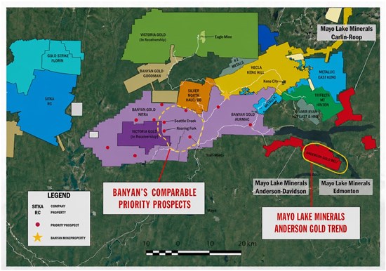
Figure 1 Location map: Tombstone Gold Belt and Keno Silver Camp. Mayo's Anderson Gold Trend is shown in relation to Nitra prospects in comparable geological settings and other regional projects.
To view an enhanced version of this graphic, please visit:
https://images.newsfilecorp.com/files/5471/309866_mayofig1.jpg
In its July 28, 2026 news release, Banyan reported 1.62 g/t Au over 5.0 metres, including 17.80 g/t Au over 0.4 metres, from Roaring Fork drillhole NT-26-001. Banyan described dense extensional quartz veining, visible gold, bismuth sulphosalts and favourable brittle strain-all features that support an intrusion-related mineralization model. Banyan also reported broad areas of anomalous and enhanced gold-in-soil values at Roaring Fork and Seattle Creek. The complete Banyan news release is available at www.banyangold.com.
Mayo interprets the gold-in-soil patterns in Figures 2 and 3 as structurally controlled. Much of Nitra's upland terrain was affected by cold-based glaciation, which can limit erosion and transport of bedrock-derived material. On that basis, Mayo believes the broad surface anomalies may broadly reflect mineralization near the bedrock-overburden interface. Structurally controlled anomaly patterns can be consistent with multiple mineralized fractures, shears or sheeted veins, although drilling is required to determine their source and significance.
Dr. Rampton added: "The structurally controlled patterns that have been identified in Banyan's published gold-in-soil figures are particularly relevant when compared with Mayo's Anderson Gold Trend. Similar patterns in Mayo's geochemical and magnetic datasets may help locate and interpret prospective RIRGS structures. These are exploration interpretations that must now be tested by drilling. Multiple trends of shears and veins with associated mineralization, including sheeted veins, have been observed at the Gold (Scheelite) Dome 1 property to the west of Roaring Fork and Seattle Creek."
. 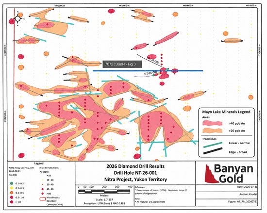
Figure 2. Roaring Fork zone-drillhole locations and gold-in-soil results.
Base map reproduced from Figure 2 of Banyan's July 28, 2026 news release.
Contours, colours and trend lines added by Dr. Vern Rampton.
To view an enhanced version of this graphic, please visit:
https://images.newsfilecorp.com/files/5471/309866_c110d9a3e4264873_003full.jpg
Banyan's Roaring Fork and Seattle Creek Zones
Banyan identified Roaring Fork and Seattle Creek through a combination of soil geochemistry, geophysical signatures, placer-mining history and prospecting. Mayo reviewed Banyan's published maps and added its own contours and trend interpretations to illustrate the distribution and possible structural control of anomalous and enhanced gold-in-soil values relative to RIRGS.
Roaring Fork. Banyan reported 1.62 g/t Au over 5.0 metres, including 17.80 g/t Au over 0.4 metres, in its first reported drillhole at Roaring Fork. The upper portion of the hole intersected numerous thin quartz veins containing bismuth sulphosalts, arsenopyrite and pyrite, with local sphalerite. The veining was interpreted as having formed in favourable brittle strain regimes.
A largely contiguous area of anomalous and enhanced gold-in-soil values shown in Figure 2 measures approximately 1,000 by 500 metres. Mayo interprets this area as most probably reflecting mineralization at the bedrock-overburden interface and a surface expression of a larger mineralized system. The relationship of grade in the bedrock at the interface relative to the gold-in-soil analytical values needs to be determined.
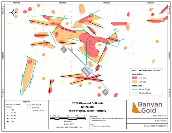
Figure 3. Seattle Creek zone drillhole location and gold-in-soil results.
Base map was reproduced from Figure 7 of Banyan's July 28, 2026 press release.
Contours and trend lines were added by Dr. Vern Rampton.
To view an enhanced version of this graphic, please visit:
https://images.newsfilecorp.com/files/5471/309866_c110d9a3e4264873_004full.jpg
Seattle Creek. Banyan reported multiple occurrences of visible gold in extensional and shear-hosted quartz veins in drillhole NT-26-006 at Seattle Creek. Some visible gold was reported intergrown with, or spatially associated with, bismuth sulphosalts, pyrrhotite and arsenopyrite.
An irregular area dominated by anomalous and enhanced gold-in-soil values measures approximately 800 by 400 metres (Figure 3). Mayo interprets this anomaly similarly to its interpretation of the Roaring Fork anomaly, as potentially reflecting mineralization at the bedrock-overburden interface. If it represents the upper expression of a mineralized system, its geometry at depth would be governed by the orientation of mineralized structures. Drilling and three-dimensional modelling are required to test this interpretation.
MAYO'S ANDERSON GOLD TREND TARGETS
The Anderson Gold Trend is a 48-square-kilometre mineralized corridor within Mayo's 86-square-kilometre Anderson-Davidson property (Figures 1and 6). Exploration has included airborne magnetics, mapping and prospecting, shallow IP-resistivity, reconnaissance geochemistry, detailed soil sampling and Soil Gas Hydrocarbon (SGH) analysis. Mayo believes the integrated datasets support drill testing at Dawn Gulch, Peak and Andy-Owl.
Structurally controlled mineralization patterns shown on gold-in-soil plots become significant when Banyan's work at Nitra is compared with that of Mayo's Anderson Gold Trend. Mayo believes that the presence of large areas of anomalous and enhanced gold-in-soil values and patterns shown by these plots may assist in locating, and explaining the nature of RIRGS. A large number of paleo-fractures and faults can be identified on certain magnetic projections over much of the northern Tombstone Gold Belt as much of the belt has been thrust and moved more than 100km to the north-north-east2. In many areas where erosion and transport by early glaciers are not factors the soil patterns will be similar to those at the bedrock interface immediately below the soil sampling areas.
Dawn Gulch An analytical-signal (AnSig) magnetic response associated with a strong SGH redox cell and gold and base-metal SGH anomalies defines a compelling buried exploration target (Figure 4). Soil data also show anomalous and enhanced values for gold and several pathfinder elements. A magnetic low measuring approximately 0.81 square kilometres may indicate an intrusion related to the target. These indicators support drill testing but do not establish the presence of a mineral deposit.
Gold-in-soil plots at Dawn Gulch show linear belts and broader areas of anomalous and enhanced values, including one area measuring approximately 800 by 400 metres (Figure 5). Mayo interprets the broad anomaly as a possible surface expression of a gold system at the bedrock interface. Its associated pathfinder-element anomalies and geophysical setting support a RIRGS target model. Drilling is required to determine the source, geometry and grade of any mineralization.
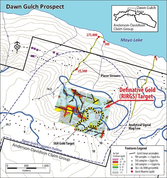
Figure 4. Dawn Gulch-integrated exploration target. The figure combines gold-in-soil linears, an SGH gold target and an analytical-signal magnetic low. These features are exploration indicators and do not establish the presence, grade or extent of a mineral deposit.
To view an enhanced version of this graphic, please visit:
https://images.newsfilecorp.com/files/5471/309866_c110d9a3e4264873_005full.jpg
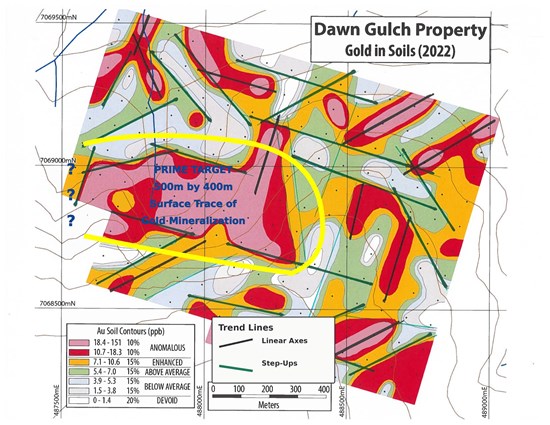
Figure 5. Dawn Gulch gold-in-soil plot.
To view an enhanced version of this graphic, please visit:
https://images.newsfilecorp.com/files/5471/309866_c110d9a3e4264873_006full.jpg
The collection, storage, shipping, geochemical analysis, SGH analysis and quality-control procedures for samples collected at Dawn Gulch were described in full in Mayo's March 2, 2026 news release.
Andy Owl A prominent structure can be traced for more than 3,000 metres using geophysics, air photographs and linear soil anomalies. Broad anomalous bands and areas occur along portions of the structure, with soil values of up to 527 ppb Au.
Two nearby reverse-circulation drillholes intersected a mineralized zone traced for approximately 50 metres. Reported intersections include 0.80 g/t Au over 6.1 metres and 0.56 g/t Au over 3.1 metres. Because both holes were collared in mineralization, the zone remains open in all directions. Reverse-circulation chips did not permit a definitive distinction between sheeted veining and disseminated mineralization. The recovered material included quartz-sulphide mineralization, stibnite, arsenopyrite, pyrite and silica-cemented breccia with an Au-Sb-Hg geochemical association-features that support a RIRGS exploration model.
Peak The third proposed drill prospect hosts a linear anomalous zone that can be traced for approximately 1.6 kilometres, with gold-in-soil values of up to 272 ppb, together with five additional subzones totalling approximately 2,290 metres. Broad anomalous areas within the subzones resemble those at Dawn Gulch and contain values of up to 340 ppb gold. Final drill targets will be selected following an integrated review of the geophysical and geochemical data.
(2) Gabrielse, H., Murphy, D.C. and Mortensen, J.K. (2006), Cretaceous and Cenozoic dextral orogen-parallel displacements, magmatism, and paleogeography, north-central Canadian Cordillera.: in Haggart, J.W., Enkin, R.J. and Monger, J.W.H., eds. Paleogeography of the North American Cordillera. Evidence For and Against Large-Scale Displacements: Geological Association of Canada, Special Paper 456, p. 255-276.
'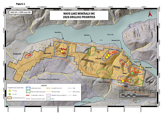
Figure 6. Anderson Gold Trend-proposed 2026 drill priorities.
Dawn Gulch, Peak and Andy Owl are highlighted in yellow as proposed initial drill targets.
To view an enhanced version of this graphic, please visit:
https://images.newsfilecorp.com/files/5471/309866_c110d9a3e4264873_007full.jpg
Next Steps Mayo proposes to drill Dawn Gulch, Peak and Andy-Owl during its initial Anderson Gold Trend campaign. The program is designed to test whether the surface geochemical, structural and geophysical indicators reflect bedrock gold systems at depth. Additional soil sampling and geophysical work may be used to refine other prospective targets along the trend, subject to financing and final program refinements.
QP Certification
The technical and scientific information contained in this news release has been prepared and approved by Dr. Vern Rampton, P.Eng., a Qualified Person as defined by National Instrument 43-101-Standards of Disclosure for Mineral Projects.
About Mayo Lake Minerals Inc. (Mayo)
Mayo is engaged in the exploration and development of three mineral properties covering 145.6 square kilometres in the Mayo-Keno area of Yukon's Mayo Mining District. All properties lie within the traditional territory of the First Nation of Na-Cho Nyäk Dun. The Mayo-Keno area lies within the Tombstone Gold Belt and the Keno Hill Silver District, which host active exploration and development programs by several companies.
Mayo's 86-square-kilometre Anderson-Davidson property contains the 48-square-kilometre Anderson Gold Trend, where more than 10,000 metres of linear gold-in-soil anomalies have been outlined. Mayo interprets these anomalies as prospective surface indicators of subsurface gold mineralization, including possible intrusion-related veining.
Mayo's 44-square-kilometre Carlin-Roop Silver property exhibits geological and geochemical evidence prospective for Keno Hill-style high-grade silver mineralization. Its Carlin West zone has a footprint and certain geological characteristics that Mayo considers comparable to those of the historic Elsa Mine. Comparisons to nearby or historical deposits are provided solely for geological context and do not imply that similar mineralization will be discovered.
At Mayo's 15-square-kilometre Edmonton property, a broad magnetic low may indicate an alteration halo above a buried intrusion. Anomalous gold, silver and base-metal geochemistry, together with positive SGH responses, define a multi-element exploration target.
Additional information is available on the Company's website at www.mayolakeminerals.com.
For additional information, please contact:
Vern Rampton, Ph.D., P.Eng., President & CEO | vrampton@mayolakeminerals.com | 613-836-2594 Ext. 2
Darrell Munro, B.A., LL.B., Corporate Administrator | dmunro@mayolakeminerals.com | 613-836-2594 Ext. 3
Lee Bowles, Director | lbowles@ironstonecapital.ca | +34 62 466 9063 or 416-561-7474
Cautionary Statement Regarding Forward-Looking Information. This news release contains forward-looking statements and forward-looking information within the meaning of applicable securities laws. Forward-looking statements include, but are not limited to, statements regarding Mayo's proposed exploration and drilling programs; the timing, scope, targets and objectives of those programs; the availability of financing; the interpretation of geochemical, geophysical, structural and drilling data; and the potential for RIRGS or other mineralization at the Company's properties. Forward-looking statements are based on management's current expectations, estimates, assumptions and beliefs, including assumptions regarding financing, regulatory approvals, contractor and equipment availability, exploration results and general market conditions. Such statements involve known and unknown risks, uncertainties and other factors that may cause actual results to differ materially from those expressed or implied. These risks include, among others, the speculative nature of mineral exploration, the possibility that exploration results will not support current interpretations, financing and commodity-price risks, operational and permitting risks, and other risks described in the Company's public disclosure. Readers should not place undue reliance on forward-looking statements.
The forward-looking statements in this news release are made as of the date hereof. Except as required by applicable securities laws, Mayo undertakes no obligation to update or revise them as a result of new information, future events or otherwise.
NOT FOR DISTRIBUTION TO UNITED STATES NEWSWIRE SERVICES OR FOR DISSEMINATION IN THE UNITED STATES
1 Hulstein, R., Zuran, R., Carlson, G.G. and Fields, M., 1999, The Scheelite Dome gold project, central Yukon, In: Yukon Exploration and Geology 1998, C.f. Roots and D.S. Emond (eds.), Exploration and Geological Services Division, Yukon, Indian and Northern Affairs Canada, p. 243-248.
To view the source version of this press release, please visit https://www.newsfilecorp.com/release/309866
Source: Mayo Lake Minerals Inc.