
Drilling through the eastern margin of the Kerr Open Pit and east of the 2026 Mineral Resource Estimate pit has defined mineralization from near surface to 300 metres depth in an area with limited previous drilling, strongly supporting an eastward extension of the open pit
TORONTO, Ontario, Sept. 21, 2026 (GLOBE NEWSWIRE) -- Cadillac Mines Corporation (TSX: CADY), ("Cadillac Mines" or the "Company") is pleased to announce assay results from expansion diamond drilling at the Chesterville East Extension ("CVE") at Kerr-Addison ("KA"), located in Virginiatown, Ontario. Results are reported for a total of 68 drill holes from an ongoing property-wide infill and expansion diamond drill program.
Today's release includes assay results from 68 drill holes totaling 28,304 metres of a planned 30,500 metres of expansion drilling at CVE, east of the former Chesterville Mine and the 2026 Mineral Resource Estimate ("MRE") resource pit. All assay results reported in this release were received after the cut-off date for the 2026 MRE and were not used in that mineral resource estimate.
Chesterville East Extension Drilling Highlights
Selected highlight results include:
- 1.36 g/t Au over 4.8 m estimated true width (ETW) in hole KAD26-407
- 1.35 g/t Au over 5.2 m estimated true width (ETW) in hole KAD26-415
- 1.28 g/t Au over 10.1 m estimated true width (ETW) in hole KAD26-507
- 2.29 g/t Au over 3.2 m estimated true width (ETW) in hole KAD26-404
- 2.44 g/t Au over 7.5 m estimated true width (ETW), and 3.21 g/t Au over 3.4 m (ETW) in hole KAD26-473
- 1.50 g/t Au over 14.4 m estimated true width (ETW) in hole KAD26-442
- 1.33 g/t Au over 8.8 m estimated true width (ETW) in hole KAD26-433
- 2.02 g/t Au over 5.6 m estimated true width (ETW) in hole KAD26-501
Rick Howes, Chief Executive Officer of Cadillac Mines, stated, "These results open up an area east of the 2026 MRE resource pit that had seen very little drilling previously, clearly demonstrating that the mineralization defined within the Kerr Open Pit continues well beyond the pits eastern limit." Mr. Howes continued, "This new mineralization is in an area that is not within our current mineral resource, and with continued drilling gives us a real opportunity to grow the Kerr open pit."
Geology and Context of Results
The Kerr-Addison Deposit is an Archean orogenic gold system located in the Abitibi Greenstone Belt. It is spatially associated with the Larder Lake Cadillac Deformation Zone (LLCDZ), a major crustal fault that acted as a conduit for hydrothermal fluids and controlled the emplacement of gold mineralization. The Kerr Fault, a steeply north dipping subsidiary splay of the LLCDZ, strikes eastward across the property and is taken as the boundary between the hangingwall to the north and the footwall panels to the south. There are five main mineralized domains that host the Kerr mineralization: Green Carbonate and Flow domains, which constitute the Main Break mineralization that accounted for over 10 million ounces of historical gold production, and the Footwall (Chesterville or CVE), Albitic and Graphitic domains which accounted for under 0.5 Moz of historic production.
The holes highlighted in this news release were drilled east of the former Chesterville Mine, targeting the eastward continuation of the footwall panels in an area that had seen very little previous drilling. Drilling in this target area began in the fourth quarter of 2025 and the initial results made this a focus of the 2026 program. These results demonstrate that the mineralization continues east of the former Chesterville workings, from within the eastern margin of the 2026 MRE resource pit to approximately 350 metres east of it, and that mineralization is present through the full vertical section on the eastern margin. Of the 68 holes drilled, 61 returned composites above the 2026 MRE cutoff grade. Most of the intersections highlighted are in areas not modelled as mineralized in the 2026 MRE and are presented from furthest east and moving west towards the edge of the 2026 MRE resource pit.
- Holes KAD26-407, KAD26-415 and KAD26-507 (Figures 1, 3 & 4) on section B-B' were drilled approximately 350 metres east of the 2026 MRE resource pit, in an area not modelled in the 2026 MRE. All three holes intersected footwall mineralization adjacent to the Kerr Fault at grades comparable to the open pit resource, approximately 260 metres below surface, indicating the footwall mineralization continues east of the Chesterville workings. KAD26-415 also intersected mineralization approximately 80 metres below surface over good width, at a grade below the open pit resource average but well above cut-off, in what is interpreted as a separate panel further south within the footwall.
- On section B-B', hole KAD26-404 (Figures 1, 3 & 4) intersected hangingwall mineralization approximately 225 metres below surface at well above the open pit resource grade. This area was not modelled in the 2026 MRE, and the result confirms vertical continuity to 250 m below surface of hangingwall mineralization between the Kerr Fault and the LLCDZ.
- Hole KAD26-473 (Figures 1, 3 & 5) was drilled on section C-C' approximately 125 metres east of the 2026 MRE resource pit. The hole returned two intersections on separate footwall panels, both in ground not modelled as mineralized in the 2026 MRE, which is present on this section only as a narrow shallow tail. The upper intersection, 2.44 g/t Au over 7.5 m (ETW), sits approximately 100 metres below surface at close to double the open pit resource average grade, immediately below an area modelled as Mineralization Potential. The lower intersection, 3.21 g/t Au over 3.4 m (ETW), sits approximately 140 metres below surface at more than double the open pit resource average grade, over roughly half the width of the upper intersection and adjacent to inferred material carried in the 2026 MRE to the south. Both intersections sit at shallow depth at grades well above the open pit resource average, east of the current pit limit.
- Holes KAD26-442 and KAD26-433 (Figures 1, 3 & 5) were drilled approximately 315 metres east of the 2026 MRE resource pit, testing the footwall domain approximately 300 metres below surface and well beyond the eastern limit of the pit. Both drill holes returned intersections at grades approximately equal to the open pit resource average, in an area not modelled as mineralized in the 2026 MRE and adjacent to volumes modelled as Mineralization Potential. Taken together these two holes define a single wide mineralized panel at this depth and demonstrate that the footwall mineralization continues east of the current pit limit.
- Hole KAD26-501 (Figures 1, 3 & 6) is the westernmost of the holes highlighted in this news release, approximately 60 metres east of the former Chesterville underground workings. The hole returned 2.02 g/t Au over 5.6 m (ETW) at a grade considerably above the open pit resource average, approximately 300 metres below surface and immediately adjacent to the Kerr Fault. The intersection sits roughly 25 metres below the eastern edge of the 2026 MRE resource pit, in ground not modelled as mineralized in that estimate, and above inferred blocks modelled in the 2026 MRE. The result demonstrates potential to deepen the pit along its eastern margin, where a revised pit shell could also capture the inferred material below the intersection.
Expansion drilling is continuing at the Chesterville East Extension, both to the east and at depth, and continuing to increase drill density in the area covered by this news release. This program is expected to conclude early in the fourth quarter of 2026.
Figure 1
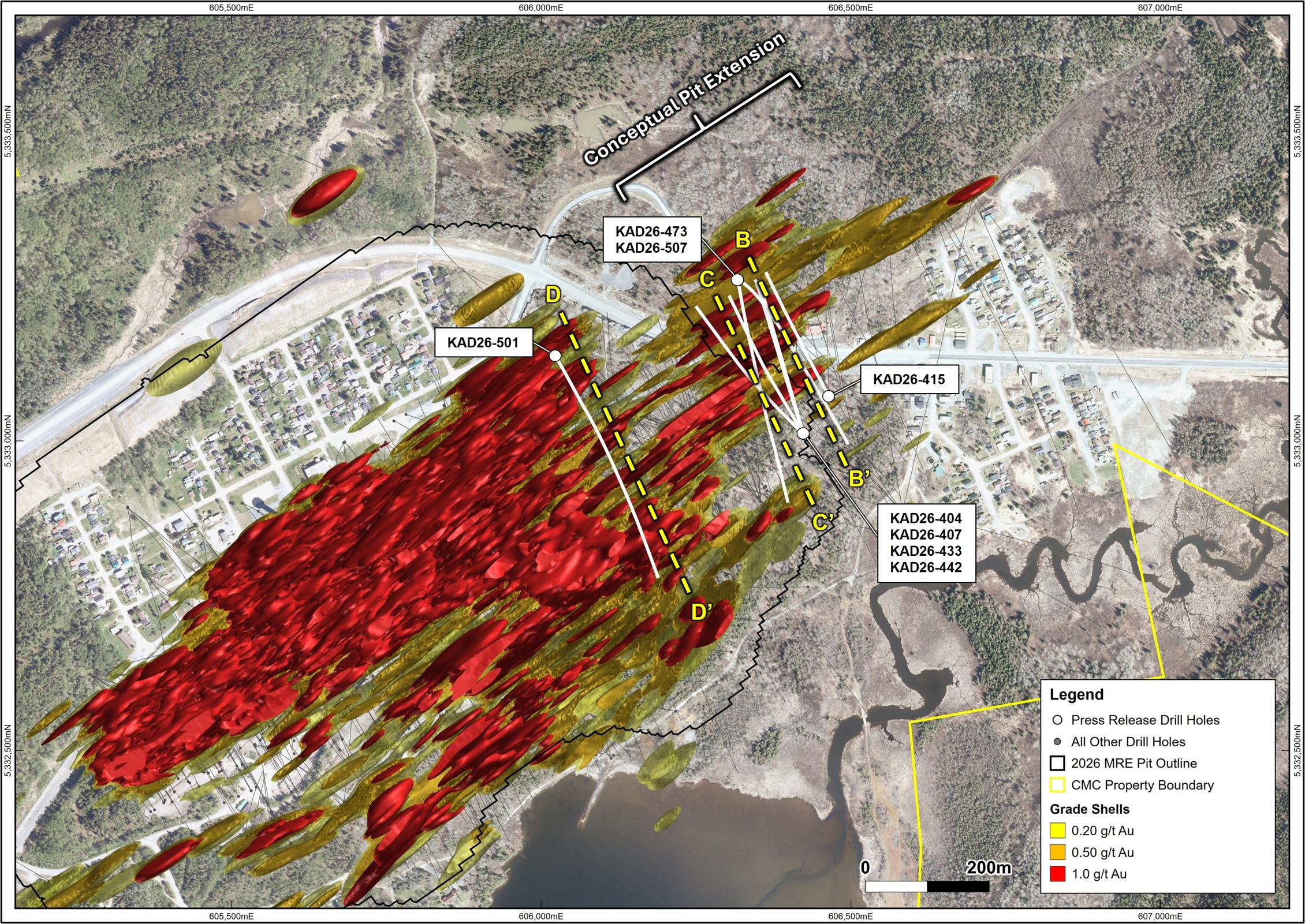
Plan Map of selected highlight drill hole section locations with recently modelled Au grade shells.
Figure 2
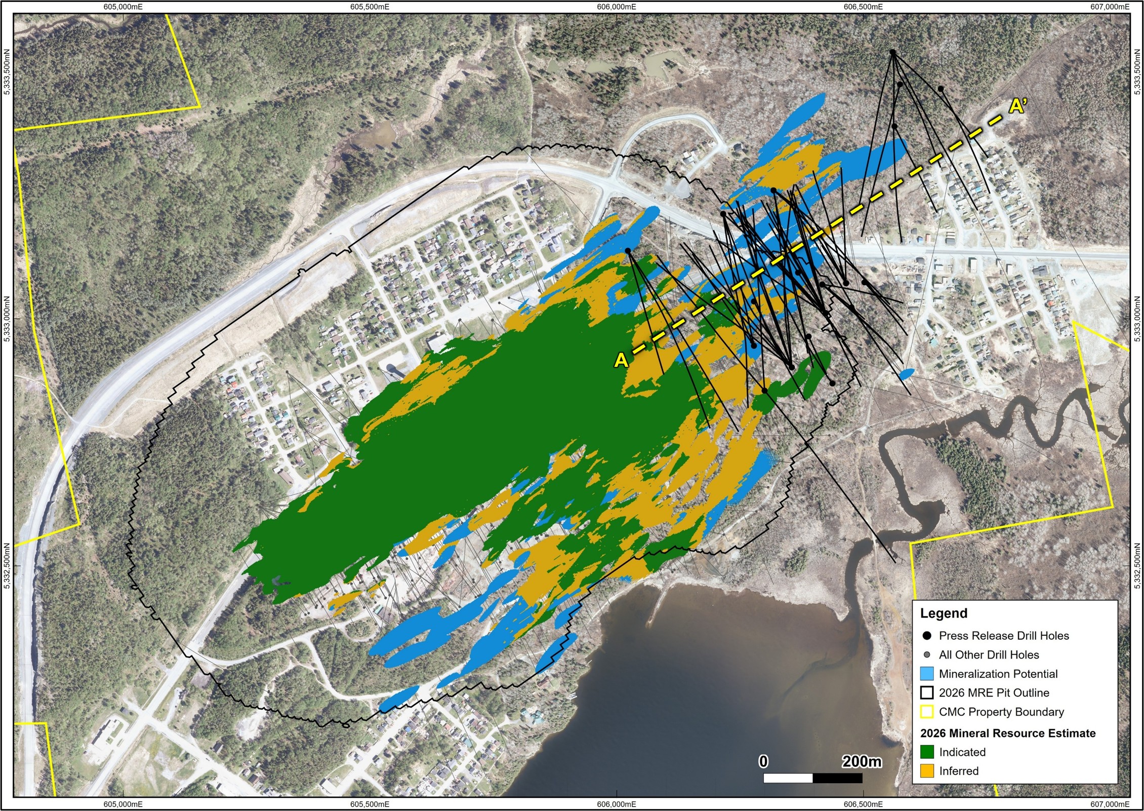
Plan Map of all drill hole locations from this release, surface projection of 2026 Mineral Resource Estimate (MRE) with MRE pit outline at surface and section lines for the A-A' presented in the current release.
Figure 3
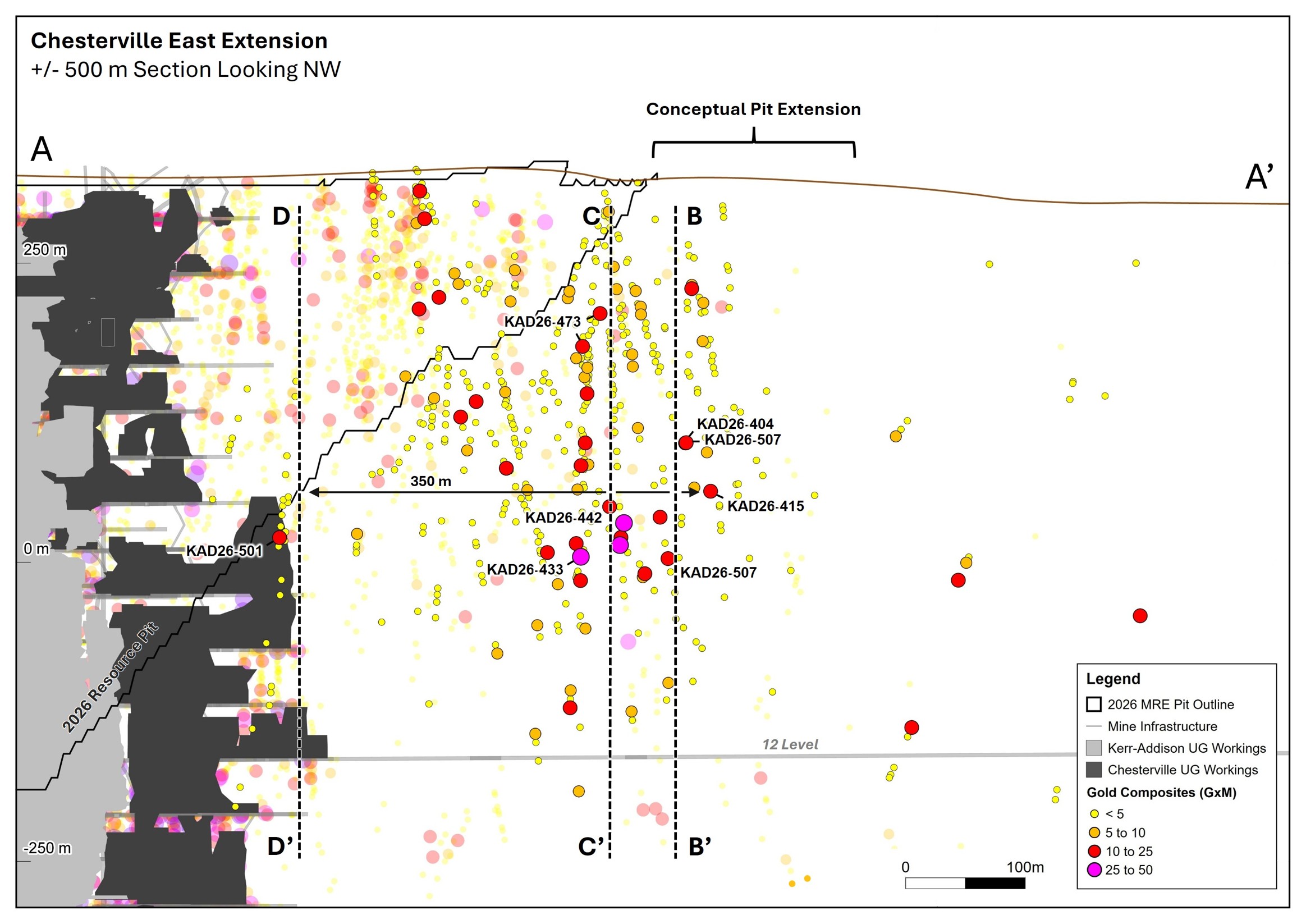
Longitudinal section A-A' looking northwest, showing all 2026 drill hole intersections from this release in full colour, with black outlines, previous drilling in semi-transparent. Intersections are sized by Au grade multiplied by metres. Intersection points with a black border and label correspond to the selected highlights presented in this release. Previously released and historical drill holes not shown.
Figure 4
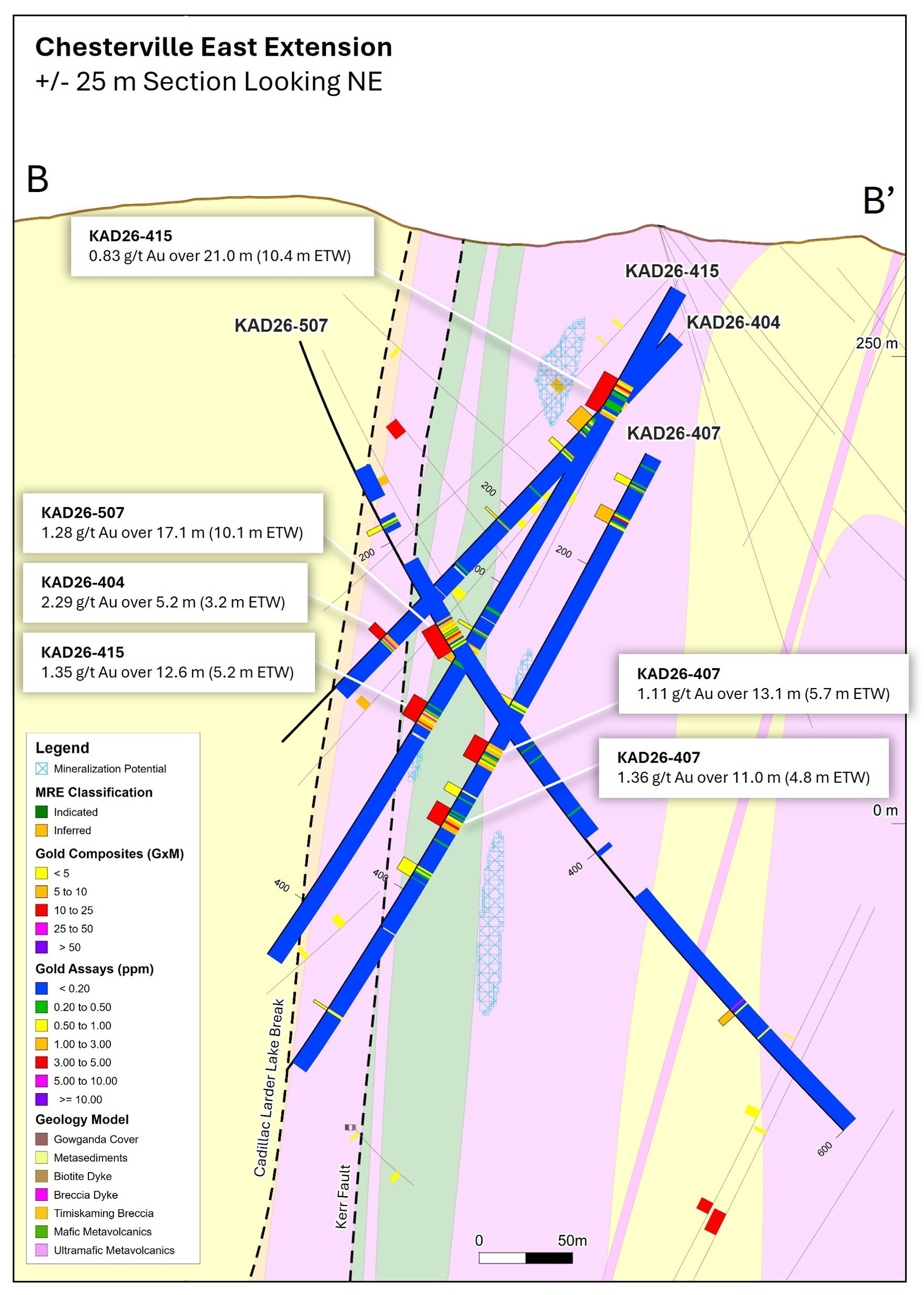
Cross section B-B' looking northeast, showing drill holes KAD26-404, KAD26-407, KAD26-415 and KAD26-507 with Mineralization Potential. Note that the 2026 MRE Resource Pit Shell does not extend to this section. Previously released and historical drill holes as well as intersections from this release that did not meet the highlight section criteria are shown in grey. Reported intervals are estimated true width (ETW).
Figure 5
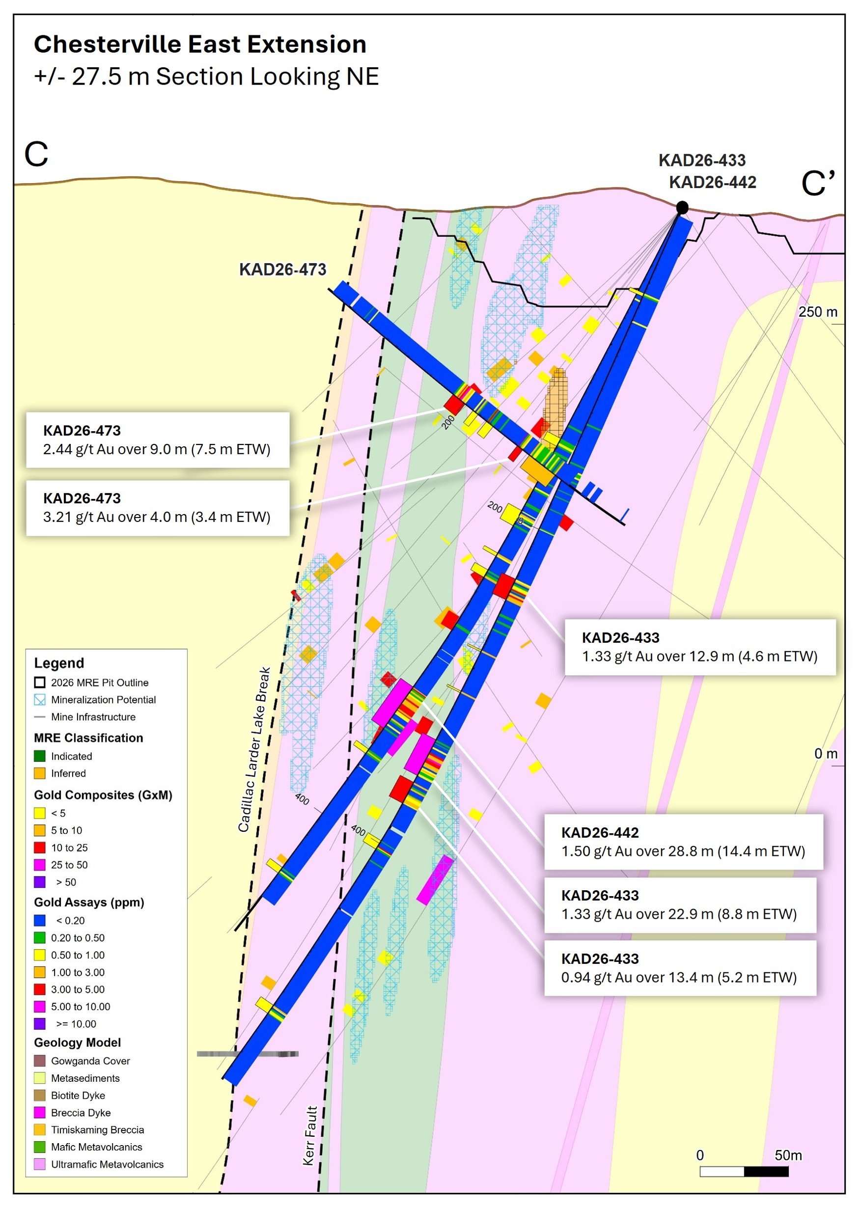
Cross Section C-C' looking northeast, showing drill holes KAD26-433, KAD26-442, and KAD26-473 with 2026 MRE Block Model, Mineralization Potential and 2026 MRE Resource Pit Shell. Previously released and historical drill holes as well as intersections from this release that did not meet the highlight section criteria are shown in grey. Reported intervals are estimated true width.
Figure 6

Cross Section D-D' looking northeast, showing drill hole KAD26-501 with 2026 MRE Block Model, Mineralization Potential and 2026 MRE Resource Pit Shell. Previously released and historical drill holes as well as intersections from this release that did not meet the highlight section criteria are shown in grey. Reported intervals are estimated true width.
Table 1. Selected Significant Results
| Hole ID | From (m) | To (m) | Downhole Interval (m) | ETW (m) | Au (g/t) | Horizon | |
| KAD26-400 | 362.3 | 369.5 | 7.2 | 4.8 | 1.72 | Footwall | |
| KAD26-404 | 294.1 | 299.3 | 5.2 | 3.2 | 2.29 | Hangingwall | |
| KAD26-407 | 350.0 | 361.0 | 11.0 | 4.8 | 1.36 | Footwall | |
| KAD26-411 | 95.0 | 100.0 | 5.0 | 3.6 | 1.23 | Footwall | |
| KAD26-415 | 275.0 | 287.6 | 12.6 | 5.2 | 1.35 | Footwall | |
| KAD26-416 | 436.3 | 443.6 | 7.3 | 4.5 | 1.25 | Hangingwall | |
| KAD26-421 | | 323.0 | 332.8 | 9.8 | 4.3 | 1.24 | Footwall |
| 495.0 | 500.8 | 5.8 | 3.1 | 1.45 | Hangingwall | ||
| KAD26-426 | 288.0 | 292.2 | 4.2 | 3.4 | 1.22 | Hangingwall | |
| KAD26-429 | 119.7 | 125.0 | 5.3 | 3.0 | 1.32 | Footwall | |
| KAD26-431 | 392.0 | 403.7 | 11.7 | 8.2 | 1.57 | Hangingwall | |
| KAD26-433 | | 231.3 | 244.2 | 12.9 | 4.6 | 1.33 | Footwall |
| 333.1 | 355.9 | 22.9 | 8.8 | 1.33 | Footwall | ||
| Incl. | 341.0 | 349.6 | 8.6 | 3.3 | 2.85 | Footwall | |
| KAD26-436 | | 265.0 | 274.0 | 9.0 | 4.5 | 1.54 | Footwall |
| 339.0 | 352.2 | 13.2 | 5.2 | 1.53 | Footwall | ||
| KAD26-442 | 311.8 | 340.5 | 28.8 | 14.4 | 1.50 | Footwall | |
| Incl. | 317.0 | 327.8 | 10.8 | 5.4 | 3.10 | Footwall | |
| KAD26-473 | | 192.0 | 201.0 | 9.0 | 7.5 | 2.44 | Footwall |
| 240.0 | 244.0 | 4.0 | 3.4 | 3.21 | Footwall | ||
| KAD26-475 | | 152.2 | 155.9 | 3.7 | 3.2 | 2.59 | Hangingwall |
| 287.0 | 295.9 | 8.9 | 7.5 | 1.32 | Footwall | ||
| KAD26-480 | 21.0 | 36.0 | 15.0 | 9.7 | 1.42 | Footwall | |
| KAD26-484A | 149.6 | 154.0 | 4.4 | 3.7 | 1.53 | Hangingwall | |
| KAD26-501 | 336.0 | 346.0 | 10.0 | 5.6 | 2.02 | Hangingwall | |
| KAD26-507 | | 249.9 | 267.0 | 17.1 | 10.1 | 1.28 | Footwall |
| 511.0 | 515.0 | 4.0 | 3.0 | 1.48 | Footwall | ||
| KAD26-527 | 31.0 | 37.0 | 6.0 | 4.0 | 1.22 | Footwall | |
Notes on Table 1:
- Estimated True Widths (ETW) are estimated based on drill hole Geology or comparison with other on-section drill holes.
- The composite assay grades presented in the summary tables are calculated using a minimum average of 0.20 g/t for Au, with a maximum of 3.0 m internal waste and no grade capping.
- Selected results presented in this table are those with a composite grade of at minimum 1.20 g/t Au over a minimum interval of 3.0 m.
- Full results can be found here-
Table 2. Drill hole locations
| Drill Hole | Easting | Northing | Elevation (masl) | Azimuth | Dip | Total Length (m) | Zone |
| KAD26-400 | 606355 | 5332902 | 316.4 | 356 | -49 | 495 | CVE Extension |
| KAD26-404 | 606424 | 5333012 | 315.6 | 343 | -47 | 375 | CVE Extension |
| KAD26-407 | 606424 | 5333012 | 315.6 | 342 | -62 | 525 | CVE Extension |
| KAD26-411 | 606465 | 5333072 | 302.0 | 328 | -45 | 273 | CVE Extension |
| KAD26-415 | 606465 | 5333072 | 302.0 | 330 | -60 | 435 | CVE Extension |
| KAD26-416 | 606355 | 5332902 | 316.4 | 341 | -51 | 533 | CVE Extension |
| KAD26-421 | 606424 | 5333012 | 315.6 | 330 | -65 | 555 | CVE Extension |
| KAD26-426 | 606574 | 5333474 | 321.5 | 195 | -51 | 465 | CVE Extension |
| KAD26-429 | 606424 | 5333012 | 315.6 | 303 | -51 | 402 | CVE Extension |
| KAD26-431 | 606559 | 5333540 | 319.0 | 175 | -63 | 645 | CVE Extension |
| KAD26-433 | 606424 | 5333012 | 315.6 | 314 | -65 | 570 | CVE Extension |
| KAD26-436 | 606424 | 5333012 | 315.6 | 314 | -61 | 570 | CVE Extension |
| KAD26-442 | 606424 | 5333012 | 316.4 | 328 | -62 | 483 | CVE Extension |
| KAD26-473 | 606318 | 5333260 | 334.7 | 170 | -45 | 459 | CVE Extension |
| KAD26-475 | 606216 | 5333212 | 329.9 | 133 | -45 | 423 | CVE Extension |
| KAD26-480 | 606278 | 5332945 | 332.6 | 339 | -52 | 342 | CVE Extension |
| KAD26-484A | 606216 | 5333212 | 329.9 | 162 | -52 | 549 | CVE Extension |
| KAD26-501 | 606023 | 5333138 | 321.6 | 149 | -63 | 723 | CVE Extension |
| KAD26-507 | 606318 | 5333260 | 334.7 | 118 | -73 | 600 | CVE Extension |
| KAD26-527 | 606368 | 5333093 | 317.9 | 330 | -47 | 165 | CVE Extension |
Notes on Table 2:
- Table contains information for 2026 diamond drill holes of the CVE program with selected results presented in Table 1.
- Coordinate system NAD83 UTM Zone 17N.
- Full drill collar table can be found here-
2026 Exploration Summary and Outlook
Kerr-Addison is the flagship property of Cadillac Mines and is located along the historic Cadillac Larder Lake Break. In 2026, Cadillac is executing its largest ever annual drill campaign, targeting the completion of 145,000 meters of diamond drilling across its entire property portfolio, including Larder and Galloway, at a budgeted cost of approximately $65 million. Through the end of August 2026, Cadillac completed 89,373 metres of drilling, representing 61% of the full-year target. Currently Cadillac is operating 11 diamond drill rigs, with five focused on expanding mineralization at its newly acquired Galloway Property, one currently testing below the known mineralization at the Geminid Nickel target, and the remainder targeting infill and expansionary drilling at Kerr-Addison. It is expected that as the infill program winds down, existing rigs will be re-deployed to the Larder Project early in the fourth quarter.
During the fourth quarter, Cadillac Mines will also be planning and implementing a property wide airborne geophysical survey covering the Larder, Galloway and Kerr properties along with a ground based deep penetrating MT geophysical survey. In addition, Cadillac has contracted Geologic AI to scan over 40,000 m of historic Galloway core from the 400-hole historical diamond drill database, collecting continuous XRF chemistry plus hyperspectral mineralogy to aid in the geologic interpretation and re-assaying of select intervals of core for Copper and Molybdenum.
Mineral Resource Estimate
The third MRE for the Kerr-Addison Deposit was prepared in accordance with the CIM Definition Standards (2014) and CIM Best Practice Guidelines (2019), as incorporated by reference in NI 43-101. The effective date of the latest MRE is February 27, 2026, and the estimate was completed under the supervision of Maxime Ménard, P.Geo., the Qualified Person responsible for the estimate.
Table 3. 2026 Mineral Resource Estimate
| Resource Category | Tonnage (Mt) | Gold Grade (g/t) | Metal Content (Moz Au) |
| Open Pit | |||
| Indicated | 74.3 | 1.3 | 3.0 |
| Inferred | 13.6 | 0.6 | 0.3 |
| Underground | |||
| Indicated | 4.1 | 2.6 | 0.4 |
| Inferred | 12.3 | 4.9 | 1.9 |
| Total | |||
| Indicated | 78.5 | 1.3 | 3.4 |
| Inferred | 25.9 | 2.7 | 2.2 |
Notes on Table 3:
- The Mineral Resource Estimate has been prepared in accordance with the CIM Definition Standards (2014) and CIM Best Practice Guidelines.
- Numbers may not sum due to rounding.
- Contained metal values are calculated using unrounded tonnage and grade values.
- Mineral Resources are reported within constraining shapes that demonstrate reasonable prospects for eventual economic extraction.
- Open pit Mineral Resources are reported within a conceptual pit shell using a cut-off grade of 0.20 g/t Au, based on the following parameters: gold price of USD 2,300/oz, exchange rate of 0.73 USD/CAD (1.37 CAD/USD), gold recovery of 91%, payable factor of 99%, royalty of 3%, selling cost of USD 5/oz, processing and G&A cost of CAD 16.50/t, mining cost of CAD 3.50/t mined, and an overall slope angle of 50°.
- Underground Mineral Resources are reported within optimized stope shapes generated using the Deswik Stope Optimizer (DSO), based on a longhole open stoping mining method. These shapes were generated using a cut-off grade of 1.2 g/t Au, based on the following parameters: gold price of USD 2,300/oz, exchange rate of 0.73 USD/CAD (1.37 CAD/USD), gold recovery of 91%, payable factor of 99%, royalty of 3%, selling cost of USD 5/oz, processing and transport cost of CAD 13.60/t, mining cost of CAD 90.13/t mined, and G&A cost of CAD 6.72/t, for a total operating cost of CAD 110.45/t. Reported grades are undiluted and reflect in-situ estimates constrained by these shapes.
- Bulk density values range from approximately 2.7 t/m³ to 2.94 t/m³, depending on lithology.
- Mineral Resources have been classified in accordance with CIM guidelines; no Measured Mineral Resources have been defined.
- Blocks located within historical mined voids and within the overburden had their gold value set to zero and are excluded from the Mineral Resource Estimate.
- Underground Mineral Resources located within 12 m of historical stopes are reported as remnant material due to increased mining complexity and operational risks associated with extracting material adjacent to historical workings.
- The Qualified Person responsible for the Mineral Resource Estimate is Maxime Ménard, P.Geo.
- The Mineral Resource Estimate is based on an octree block model with a parent block size of 5 m × 5 m × 5 m, constructed in Leapfrog Edge and constrained by geological domains, topography and historical void models.
Quality Assurance and Quality Control Procedures
Cadillac Mines maintains an internal quality assurance and quality control (QA/QC) program at the Kerr-Addison Project to ensure sampling and analysis of all exploration work is conducted in accordance with industry-standard best practices.
Drill core is logged and sampled at core logging facilities in Virginiatown and Rouyn-Noranda under the supervision of a Qualified Geologist. Sample intervals are selected by a geologist based on geological observations, with sample numbers, certified reference materials (CRMs), and blanks inserted into the sample sequence and recorded in the database. Drill core is cut in half using an automated core saw equipped with a diamond-tipped blade. One half of the core is placed in labelled plastic sample bags and then packaged in rice bags for shipment, while the remaining half is returned to the core box and retained for future reference. Saws and surrounding areas are thoroughly cleaned at the end of every shift and between each hole.
Core samples are transported by Manitoulin Transport to ALS Geochemistry in Thunder Bay for sample preparation and gold analysis and then shipped to ALS Geochemistry in North Vancouver for multi-element analysis. Sample preparation includes crushing the sample to at least 70% passing 2 mm. A 500 g sub-sample is collected using a riffle splitter, transferred into a sealed and uniquely coded jar, and analyzed for gold by Photon Assay. A second sub-sample of up to 250 g is collected using a riffle splitter, pulverized to at least 85% passing 75 microns, and analyzed for multi-element chemistry using four-acid digestion of a 0.25 g analytical split with an ICP-AES finish.
Cadillac Mines inserts CRMs (5%), blanks (5%), and duplicate (5%) samples into the sample stream to monitor analytical accuracy, contamination, and sampling precision. ALS Laboratories are an ISO/IEC accredited laboratory and maintain internal quality control procedures, including the insertion of laboratory blanks, reference materials, and pulp duplicates.
Qualified Person
Mr. Kerry Sparkes, M.Sc. P.Geo is Cadillac's SVP Exploration and the Qualified Person who has approved the technical information disclosed in this release.
Messrs. Maxime Menard, P.Geo and Sunil Koppalkar, P.Eng., from G Mining Services Inc. are the Qualified Persons (QPs) responsible for the preparation of the Kerr Addison Mineral Resource Estimate.
About Cadillac Mines
Cadillac Mines Corporation is a Canadian mineral exploration company advancing a growing portfolio of gold and critical mineral projects along the prolific Cadillac-Larder Lake Break in Ontario and Québec. Anchored by the historic Kerr-Addison Mine, the Company is focused on expanding its gold resource base, advancing the Geminid nickel deposit and unlocking the broader potential of its district-scale Abitibi land position. Through disciplined exploration, technical excellence and responsible development, Cadillac Mines is working to create lasting value for shareholders, communities and other stakeholders. For more information about the Company, please visit www.cadillacmines.com.
For further information, please contact:
Hannes Portmann, Chief Financial Officer
hportmann@cadillacmines.com
Forward-Looking Information
This news release includes certain "forward-looking statements" under applicable Canadian securities legislation. Forward-looking statements include, but are not limited to, statements with respect to future development plans and the business and operations of the Company. Forward-looking statements are necessarily based upon estimates and assumptions that, while considered reasonable, are subject to known and unknown risks, uncertainties and other factors which may cause the actual results and future events to differ materially from those expressed or implied by such forward-looking statements. Such factors include, but are not limited to business integration risks; fluctuations in general macroeconomic conditions; fluctuations in securities markets; fluctuations in spot and forward prices of gold, silver, base metals or certain other commodities; fluctuations in currency markets; results of exploration; the economics of processing methods; change in national and local government, legislation, taxation, controls, regulations and political or economic developments; risks and hazards associated with the business of mineral exploration, development and mining (including environmental hazards, industrial accidents, unusual or unexpected formations pressures, cave-ins and flooding); inability to obtain adequate insurance to cover risks and hazards; the presence of laws and regulations that may impose restrictions on mining; employee relations; relationships with and claims by local communities and indigenous populations; availability of and increasing costs associated with mining inputs and labour; the speculative nature of mineral exploration and development (including the risks of obtaining necessary licenses, permits and approvals from government authorities); and title to properties.
There can be no assurance that such statements will prove to be accurate, as actual results and future events could differ materially from those anticipated in such statements. Accordingly, readers should not place undue reliance on forward-looking statements. The Company disclaims any intention or obligation to update or revise any forward-looking statements, whether as a result of new information, future events or otherwise, except as required by law.
Photos accompanying this announcement are available at:
https://www.globenewswire.com/NewsRoom/AttachmentNg/abf25d8b-020b-47d4-a29c-2ad92d26acb9
https://www.globenewswire.com/NewsRoom/AttachmentNg/aee073fe-93ea-458c-98ad-a138b380bd56
https://www.globenewswire.com/NewsRoom/AttachmentNg/f6fff920-f4bd-4d80-85e0-889c07beacf1
https://www.globenewswire.com/NewsRoom/AttachmentNg/606fcf06-4659-465a-8731-aa2bf370ae7b
https://www.globenewswire.com/NewsRoom/AttachmentNg/0712fac9-064c-41d0-b396-73857b405af9
https://www.globenewswire.com/NewsRoom/AttachmentNg/67ec115d-21c4-45cb-9027-9ff183fa81b5

