
Boise, Idaho--(Newsfile Corp. - October 26, 2026) - Thunder Mountain Gold, Inc. (OTCQB: THMG) (TSXV: THM) ("Thunder Mountain Gold" or the "Company") reports that its 2026 core drilling program at the South Mountain Project in Owyhee County, Idaho, has intersected new Carbonate Replacement Deposit (CRD) mineralization at Kentucky Ridge, about 250 meters northwest and on strike of the known CRD zone. Drilling also confirmed porphyry-style intrusive rocks and alteration at the Gold Breccia and Birthday targets, which the Company believes may be the source of South Mountain's massive sulfide mineralization.
Highlights
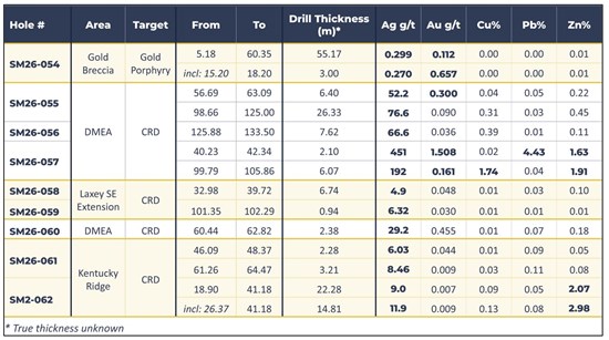
New CRD step-out at Kentucky Ridge: Hole SM26-062 intersected 22.28 m grading 2.07% Zn and 9.00 g/t Ag, including 14.81 m grading 2.98% Zn and 11.9 g/t Ag, about 25 m down-plunge from a surface gossan that channel-sampled 7.6 m at 125 g/t Ag, 1.2% Pb and 1.7% Zn.
Known CRD zone extended toward surface: Hole SM26-060 returned 2.38 m grading 29.2 g/t Ag and 0.455 g/t Au, extending DMEA Zone mineralization up-dip.
Porphyry systems confirmed: At Gold Breccia, SM26-054 returned 55.17 m grading 0.112 g/t Au, including 3.0 m at 0.657 g/t Au. At Birthday, two holes beneath a strong MT anomaly cut five porphyry intrusive phases with intense, widespread sericite alteration and pyrite-biotite ± quartz veinlets and notable chalcopyrite.
2026 Program complete: Fourteen core holes were completed totaling 2,670 m (8,760 ft). Assays have been received for 9 holes; results for 5 holes, including all Birthday drillholes, are pending.
Dr. Steven Osterberg, Senior Vice President of Exploration, said: "The 2026 program identified new CRD massive sulfide-related mineralization and confirmed two highly altered, sulfide-bearing porphyry centers associated with MT anomalies. These centers, or others not yet drilled, may be the 'engines' driving mineralization at South Mountain. With multiple MT anomalies still untested, we see potential for additional porphyry discoveries in what is now a district-scale opportunity."
Rich Leveille, Thunder Mountain Gold Inc. Technical Committee Member, added, "These are very promising results opening up new opportunities at South Mountain and definitely merit follow-up with additional drilling."
CRD Drilling: New Mineralization at Kentucky Ridge and Extensions of the Known Zone
Drilling began in June 2026 and was completed in the third quarter. Ten of the fourteen holes targeted CRD massive sulfide mineralization. They tested extensions of the known 800 m zone, which hosts several cigar-shaped massive sulfide bodies, and searched for new occurrences beyond it (Figure 1).
Kentucky Ridge (northwest). The Company targeted the down-plunge projection of a surface gossan that channel-sampled 7.6 m at 125 g/t Ag, 1.2% Pb and 1.7% Zn. Step-out hole SM26-062, drilled to test this zone at depth, intersected 22.28 m grading 9.00 g/t Ag and 2.07% Zn about 25 m down-plunge from that channel sample (Table 1). Company geologists believe this surface and near-surface mineralization may be the upper expression of a new CRD body, about 250 m from the known 800 m zone. Hole SM26-063 tested beneath this intercept; results are pending.
DMEA Zone (known CRD). Hole SM26-060 returned 2.38 m grading 29.2 g/t Ag and 0.455 g/t Au. Together with SM26-055, -056 and -057 (reported September 7, 2026), these results extend the known DMEA Zone mineralization up-dip toward surface. Nearby, hole SM26-061 (Figure 1) intercepted anomalous Ag in two zones (2.28m @ 6.03 g/t and 3.21m @ 8.46 g/t) and is thought to have slightly undercut the plunging Kentucky mineralization.
Southeast of the known CRD zone. Step-out holes SM26-058 and -059 intersected intensely altered Laxey Marble and a felsic dike with widespread sericite and pyrite alteration possibly reflecting the fringe of another CRD body. Assays show elevated silver (6.74m @ 4.90 g/t and 0.94m @ 6.32 g/t) in these rocks.
Bay State (northwest of Kentucky and on strike). Hole SM26-064 also tested a CRD step-out target and intercepted hedenbergite skarn alteration of marble along with carbonate dissolution textures; all assay results are pending.
Porphyry Drilling: Gold Breccia and Birthday
Four holes tested intrusive-hosted targets near and farther from the known CRD mineralization. The Company followed up on previous exploration at Gold Breccia (Figure 1), a target it first identified in 2009, and made the first tests of a new porphyry target at Birthday. Geological mapping, surface geochemistry and a magnetotelluric (MT) survey by Durango Geophysical Operations ("Durango") defined these targets. The MT survey identified several low-resistivity anomalies, zones that conduct electricity more readily than surrounding rock, at Gold Breccia, Birthday and other untested targets (Figure 2).
Gold Breccia. Hole SM26-054 returned 55.17 m (181 ft) from the surface grading 0.112 g/t Au (Table 1), including 3.0 m at 0.657 g/t Au in a heterolithic igneous/hydrothermal breccia. Below the breccia, several porphyry-style features occur in granodiorite, including crowded porphyry textures, sericite alteration, secondary biotite, and skarn-related calc-silicate minerals. Sulfides are rare to common and occur dominantly as disseminations and as 1 mm to 2 cm wide veinlets of pyrrhotite. Rare sphalerite and arsenopyrite are also present. The core also contains a heterolithic pebble dike with milled fragments. Together, these features support the interpretation that the deeper MT anomaly may reflect porphyry-related sulfides.
Birthday. The Company drilled three holes at what its geologists consider the strongest porphyry target to date. Holes SM26-065 and -067 tested a strong MT anomaly (Figure 2) and confirmed porphyry-style textures and alteration seen in rare outcrops; a thin cover of younger basalt hides almost the entire area. The two holes cut five quartz-feldspar or feldspar-dacite porphyry phases. The porphyry shows intense, pervasive sericite alteration overprinted by stockwork/hydrofracture-textured biotite-pyrite ± quartz veinlets. Company geologists believe this may be quartz-sericite-pyrite (QSP) alteration, which forms zoned shells around mineralized porphyry systems. Disseminated pyrite and mm-scale veinlets of pyrite with trace copper sulfide (chalcopyrite) are common throughout the porphyry (typically 2-5%) and are typically associated with quartz and/or biotite. Veins are typically 1-5 mm in width. A single larger massive sulfide vein of 6.5 cm width similarly cuts the porphyry. The vein comprises an estimated 50% pyrite and 15% chalcopyrite with subordinate pyrrhotite, arsenopyrite, and quartz. The third hole, SM26-066, was abandoned near surface due to drilling difficulties in basaltic cover rocks. All Birthday assays are pending.
Cautionary Statement
The Company cautions that CRD-related or porphyry textures, alteration and sulfides as noted do not necessarily indicate that economic type(s) of mineralization will occur at South Mountain, and if present, that the mineralization will occur in sufficient quantity or grade that would be economic to mine. This information is provided for context and as an element of the prospectivity analysis of the Company's property.
Next Steps
Surface work continues through the end of the 2026 field season to support targeting for the planned 2027 drill program:
- Induced Polarization (IP) survey: Durango is running orientation lines over gossan outcrops in the resource area to calibrate survey lines that will extend along covered, untested parts of the Laxey Marble. Results are pending.
- Soil geochemistry: The Company is expanding its soil sampling grid over targets identified by earlier geophysics and mapping.
- Geological mapping: Ongoing mapping is documenting how structure and stratigraphy control CRD and porphyry-style alteration and mineralization.
The Company's focus at South Mountain is unchanged: establish the size of the CRD massive sulfide system and determine which of the porphyry center(s) along the Laxey Marble is its source.
Table 1. 2026 Drillhole Assay Intercepts
To view an enhanced version of this graphic, please visit:
https://images.newsfilecorp.com/files/8664/320834_thunder1.jpg
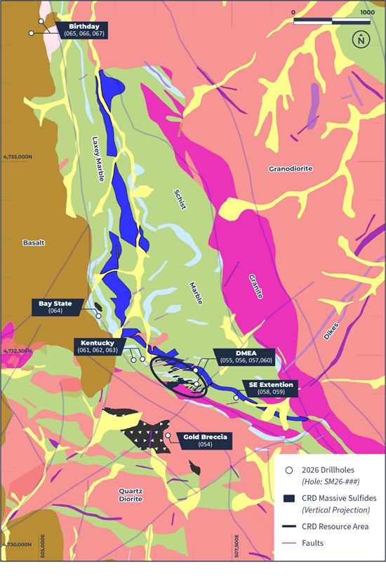
Figure 1: South Mountain Mine Area Geology with 2026 drill holes.
To view an enhanced version of this graphic, please visit:
https://images.newsfilecorp.com/files/8664/320834_78e63bdce4d3d898_003full.jpg
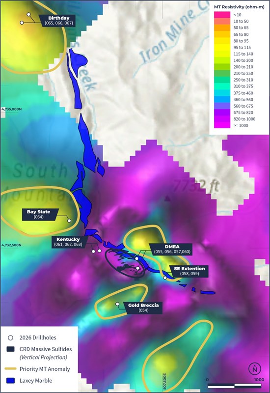
Figure 2: Priority MT anomalies, Laxey Marble and 2026 drill holes.
To view an enhanced version of this graphic, please visit:
https://images.newsfilecorp.com/files/8664/320834_78e63bdce4d3d898_004full.jpg
Other Corporate News
The Company announces that pursuant to its Corporate Stock Option Plan, the Company has granted Ron Clayton, newly appointed Director of the Board, 400,000 stock options to purchase common shares in the capital stock of the Company. The 400,000 options are exercisable on or before 5:00 p.m. (Pacific Time) on October 14, 2031, at a price of $0.75 per share.
About the South Mountain Project
South Mountain is a polymetallic silver, zinc, gold, copper and lead project on private land about 70 miles southwest of Boise, Idaho. Mining began in the 1860s with high-grade silver from surface exposures of the polymetallic chimneys in the Laxey Marble. Historic mining began during World War II and continued intermittently into the late 1960s, most notably under Anaconda Copper, developing more than 8,000 feet of drifts, shafts, raises and stopes. Historical smelter records show about 53,642 tons were shipped at average grades of 14.5% Zn, 10.6 oz/t Ag (363 g/t), 0.058 oz/t Au (1.99 g/t), 1.4% Cu and 2.4% Pb.
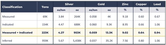
The Company acquired the mine in 2007 and has invested over US$25 million in the project. It has rehabilitated about 4,000 feet of underground workings to MSHA-compliant condition and outlined significant massive sulfide mineralization through underground core drilling. The high-grade CRD zones remain open at depth and along strike. Through recent land purchases, staking and leases, including 113 acres of private land adjoining the historic mine and Gold Breccia, 423 lode claims (about 8,200 acres) on adjoining BLM land, a 1,073-acre private lease and a State of Idaho lease, the Company has added 13,061 acres, or about 20 square miles, to its property position. The Company completed a Mineral Resource Estimate in 2023 (Table 2).
Table 2. 2023 Mineral Resource Estimate
To view an enhanced version of this graphic, please visit:
https://images.newsfilecorp.com/files/8664/320834_thunder2.jpg
Refer to S-K 1300 Technical Resource Statement and NI 43-101 Technical Report: Updated Mineral Resource Estimate for the South Mountain Project, dated December 31, 2023, and December 15, 2023, respectively, available at www.sec.gov and www.sedarplus.ca.
Sampling Methodology, Chain of Custody, Quality Control and Quality Assurance
Cutting and sampling of drill core were directed by Thunder Mountain Gold geologists. The drilling contractors transported the core samples to the Company's secure facility in nearby Jordan Valley, Oregon. An independent contractor delivered these and additional surface samples collected by geologists to MSA Labs for sample preparation in Elko, Nevada. The sample prep process included drying, crushing 1 kg to 2 mm, splitting 250 g and pulverizing rock material to 85% at -75 µm. Quality control was monitored by the insertion of numerous blind certified standard reference materials, duplicates, and blanks into each sample shipment. Drill samples were assayed by MSA Labs for gold by fire assay of a 30-gram charge with an AA finish (code FAS-111). Satisfactory results were achieved for all quality control samples related to the data reported herein. In addition, samples were submitted for multi-element analysis (48 elements) by 0.25 g 4-acid digestion and ICP-MS ultra-trace finish (code IMS-230).
Qualified Person
The technical information in this news release was reviewed and approved by Steven A. Osterberg, Ph.D., P.G., the Company's Senior Vice President of Exploration, a Qualified Person as defined by S-K 1300 and National Instrument 43-101. Dr. Osterberg is not independent of the Company as he is an officer.
Cautionary Statement
The opinions expressed regarding the potential of the exploration results should not be relied upon as an indication of future economic viability of the targets at the South Mountain Project. Characterization of certain targets as discoveries will require additional geologic studies and exploration drilling.
About Thunder Mountain Gold, Inc.
Founded in 1935, Thunder Mountain Gold Inc. is a junior exploration company developing base and precious metals assets in the western United States. Its principal asset is the South Mountain Project, a historic former Anaconda Copper Company development on private and state land in Owyhee County, Idaho, containing zinc, silver, gold, lead and copper. The Company also owns 100% of the Trout Creek Project, a gold exploration property in Nevada surrounded by Nevada Gold Mines, a Barrick-Newmont joint venture. For more information, visit www.thundermountaingold.com, www.sec.gov and www.sedarplus.ca.
Cautionary Note to Investors
This news release is intended for release in the United States only. Neither the TSX Venture Exchange, the OTCQB, nor either of their Regulation Services Providers (as that term is defined in policies of the TSX Venture Exchange) accepts responsibility for the adequacy or accuracy of this release.
For further information, please contact:
Thunder Mountain Gold, Inc.
Eric T. Jones
President and Chief Executive Officer
Eric@thundermountaingold.com
Office: (208) 658-1037

To view the source version of this press release, please visit https://www.newsfilecorp.com/release/320834
