
VANCOUVER, BC / ACCESS Newswire / November 12, 2026 / Storm Exploration Inc. (TSXV:STRM) (" Storm " or the " Company ") today announces that it intersected disseminated and/or semi-massive to massive sulphide mineralisation in all eight holes drilled at the newly discovered mineralised VMS system of the company's 100%-owned Gold Standard Project, located 60 km north of Fort Frances, Ontario, Canada.
Highlights
- Eight holes totalling 1,594 m have been completed, testing 1.9k m of the north-south striking portion of the 7 km long geophysical conductor.
- All holes intersected disseminated and/or semi-massive to massive sulphide mineralisation.
- Assays results for these holes are expected in early Q1/2027.
"The lithologies, alteration and mineralisation observed in these drillholes confirm that a VMS system is the source of the 7 km-long corridor of conductive rocks at Gold Standard," says Storm President and CEO Bruce Counts. "Based on these results, we are eager to assess the lateral and vertical potential of this extensive system and have commenced additional mapping and ground VLF on site in preparation for the resumption of drilling in the Q2/2027."
Geology Overview
The geology of the core from the 2026 drilling at Gold Standard has been reviewed by Dr Stephen Piercey PhD, P.Geo., and is interpreted as a bimodal-mafic sub-type of a volcanogenic massive sulphide system. These types of VMS deposits are dominated by mafic volcanic rocks but include up to 25% felsic volcanic rocks in the sequence, the latter often hosting mineralization. Deposits from the Noranda, Flin Flon-Snow Lake and Kidd Creek camps are classic examples of this type of VMS sub-type.
This interpretation is supported by the presence of bedded and deformed sulphides, quartz alteration, chlorite-sericite alteration and metamorphosed equivalents (chlorite-garnet), and a polymetallic sulphide assemblage within a bimodal submarine volcanic sequence. The felsic volcanic horizon appears to host the best mineralization and represents the principal target lithology at Gold Standard.
Detailed geological descriptions of each hole follow:
GS26001
GS26001 intersected chlorite-altered mafic volcanic flows, tuffs, gabbro, and later porphyry and diabase dykes. The main mineralised interval, 46.7-53.93 m, comprises sulphide-facies exhalite with bedded magnetite and folded, laminated sulphides. It is dominated by pyrrhotite with lesser pyrite, minor sphalerite and chalcopyrite; the 49.75-52.6 m section is locally semi-massive.
The sequence is pervasively chlorite altered, with carbonate, quartz, and sericite alteration concentrated around the massive sulphide horizon and adjacent volcanic units; strong sericite alteration and potassic bleaching occur in the felsic tuff between 67.7 and 73.15 m. Several quartz and quartz-carbonate veins cut the sequence, including a 1 m massive quartz vein at 48-49 m that carries blebby (remobilized?) pyrite and pyrrhotite, while carbonate stockwork veining is developed at 16-21 m.
GS26002
GS26002 intersected chlorite-altered mafic flows, pillow basalts, hyaloclastite breccias, argillaceous mudstones, and intermediate to felsic volcanic rocks. Mineralisation occurs as thin laminated exhalative sulphide horizons in argillite and a broader replacement zone in sericite-quartz altered felsic tuff. Mineralisation occurs as several thin, laminated to bedded exhalative sulphide horizons within dark argillaceous mudstones, plus a broader replacement-style zone in strongly sericite- and quartz-altered felsic tuff. The main intervals are 73.0-75.94 m and 97.15-97.5 m, which are both dominated by pyrrhotite and pyrite; and 108.75-111.42 m where laminated sulphide reaches an estimated 20% of the rock volume.
The strongest logged interval is 126.7-129.3 m in deformed felsic tuff, containing an estimated 25% sulphides, including blebby chalcopyrite, with a further 10% disseminated sulphide in the immediately underlying mixed volcanic interval. Sulphides are dominantly very fine grained pyrrhotite with subordinate pyrite, occurring as laminated, bedded, disseminated, fracture-hosted, stringer, and locally replacement textures.
GS26003
GS26003 intersected intermediate tuffs and flows, garnetiferous basalt, lapilli tuff, strongly quartz-altered felsic volcanic rocks, and gabbro. Widespread low-abundance sulphide mineralisation intensifies downhole, with the best zone from 110.1 to 123.0 m in quartz-altered felsic volcanic and tuffaceous rocks. Mineralisation is widespread but generally low to moderate in intensity, occurring mainly as fine-grained disseminated pyrite with lesser pyrrhotite, and becomes increasingly polymetallic and structurally controlled/remobilized? downhole.
The best mineralisation is between approximately 110.1 and 123.0 m, where sulphides occur as veinlets, disseminations, and interstitial aggregates within strongly quartz-altered felsic volcanic rocks and adjacent tuffaceous/mixed mafic units. The strongest interval, 114.5-115.0 m, contains an estimated 25% sulphides dominated by pyrite and pyrrhotite with lesser amounts of sphalerite and chalcopyrite; nearby intervals from 110.1-112.5 m and 118.6-119.7 m contain approximately 15% sulphide mineralization that is dominated by pyrrhotite with lesser amounts of pyrite, sphalerite and trace chalcopyrite.
Alteration is dominated by chlorite in the mafic units, with fracture-controlled sericite and quartz in the upper tuffs, patchy epidote and albite, and strong pervasive silicification with local potassic alteration through the felsic volcanic interval from 104 to 114 m.
GS26004
GS26004 intersected bedded intermediate and mafic lapilli tuffs, minor andesite and rhyolite, chert-bearing felsic volcaniclastic rocks, and chlorite-altered gabbroic sills/mafic flows. The key mineralised interval occurs from 172.62 to 181.4 m in a rhyolitic volcaniclastic unit with banded chert, where massive to semi-massive, bedded and interstitial sulphide forms the matrix to rhyolitic clasts and fragmented quartz veins.
The sulphide assemblage is strongly polymetallic: the logged 172.6-173.1 m and 179.5-179.9 m intervals contain an estimated 70% sulphide mineralization that is dominated by pyrrhotite, with lesser amounts of pyrite, sphalerite, and chalcopyrite, as well as minor chalcocite. Mineralisation is stratiform to stratabound, with the strongest sulphide developed near chert-rich horizons and sphalerite concentrated toward the base of the zone.
GS26005
GS26005 intersected bedded intermediate and mafic lapilli tuffs, rhyolitic volcaniclastic rocks, chert-bearing exhalative units, and chlorite-altered gabbroic sills. The main mineralised interval is 189.2-201.86 m, within strongly quartz-, epidote-, and chlorite-altered felsic tuff and pillow-fragment breccia. Mineralisation comprises laminated, bedded, blebby, and semi-massive sulphides dominated by pyrrhotite with pyrite, sphalerite, and chalcopyrite.
The strongest logged intervals, 191.4-195.0 m and 196.8-199.1 m, contain an estimated 25% sulphides that are dominated by pyrrhotite and pyrite with lesser amounts of sphalerite and chalcopyrite. Alteration included strong quartz, sericite, epidote, chlorite, with local metamorphosed equivalents containing garnet, together with bedded chert and sulphide.
GS26006
GS26006 intersected mainly chlorite-altered basalt, gabbroic mafic flows/sills, pillow basalt, and minor mafic tuff, with late diabase dykes. Mineralisation consists mostly of trace fracture-hosted pyrite, with a narrow-laminated pyrite bed at 30.47-31.85 m. Bedded sulphide was encountered within mafic tuff at 54.43-58.75 m, where sulphides are laminated to bedded and locally include pyrrhotite and chalcopyrite. Strong chlorite, carbonate, epidote, and local sericite alteration, and pillow basalt, are consistent with the broader submarine volcanic setting.
GS26007
GS26007 intersected chlorite-altered basalt, pillow basalt, mafic and intermediate tuffs, argillaceous mudstone, and gabbroic sills/flows. Mineralisation is moderate and occurs as bedded, laminated, stringer, interstitial, and locally replacement-style pyrite-pyrrhotite, with the best intervals at 47.07-52.93 m, 62.5-63.5 m, 97.52-100.4 m, and 109.1-112.2 m. Strong chlorite, carbonate, quartz, sericite, epidote, and chlorite-garnet-magnetite alteration was present, together with bedded sulphide, pillowed mafic volcanics, and quartz-carbonate veining.
GS26008
GS26008 intersected a submarine volcaniclastic sequence of felsic and intermediate lapilli tuffs, chlorite-garnet altered mafic tuff, pillow basalt, and chlorite-altered gabbro. The main mineralised interval is 120.98-149.52 m, hosted by strongly chlorite-, sericite-, and quartz-altered felsic lapilli tuff.
The best section, 144.0-149.52 m, contains semi-massive to massive replacement-type sulphide with up to 70% sulphide mineralization, including pyrrhotite, pyrite, sphalerite and chalcopyrite. Sulphides occur as interstitial replacement textures around quartz altered rhyolitic lapilli and quartz fragments, with a broader pyrite halo from 120.98-144.0 m. Strong chlorite, sericite, quartz, epidote, carbonate, and chlorite-garnet alteration, combined with the polymetallic pyrite-pyrrhotite-sphalerite-chalcopyrite assemblage and volcaniclastic host rocks are consistent with a VMS origin.
*Visual estimates of sulphide abundance are preliminary geological-logging observations and are not a substitute for assay results; assays are required to determine grades, metal content, and true widths.
Figure 1 - Drillhole location map
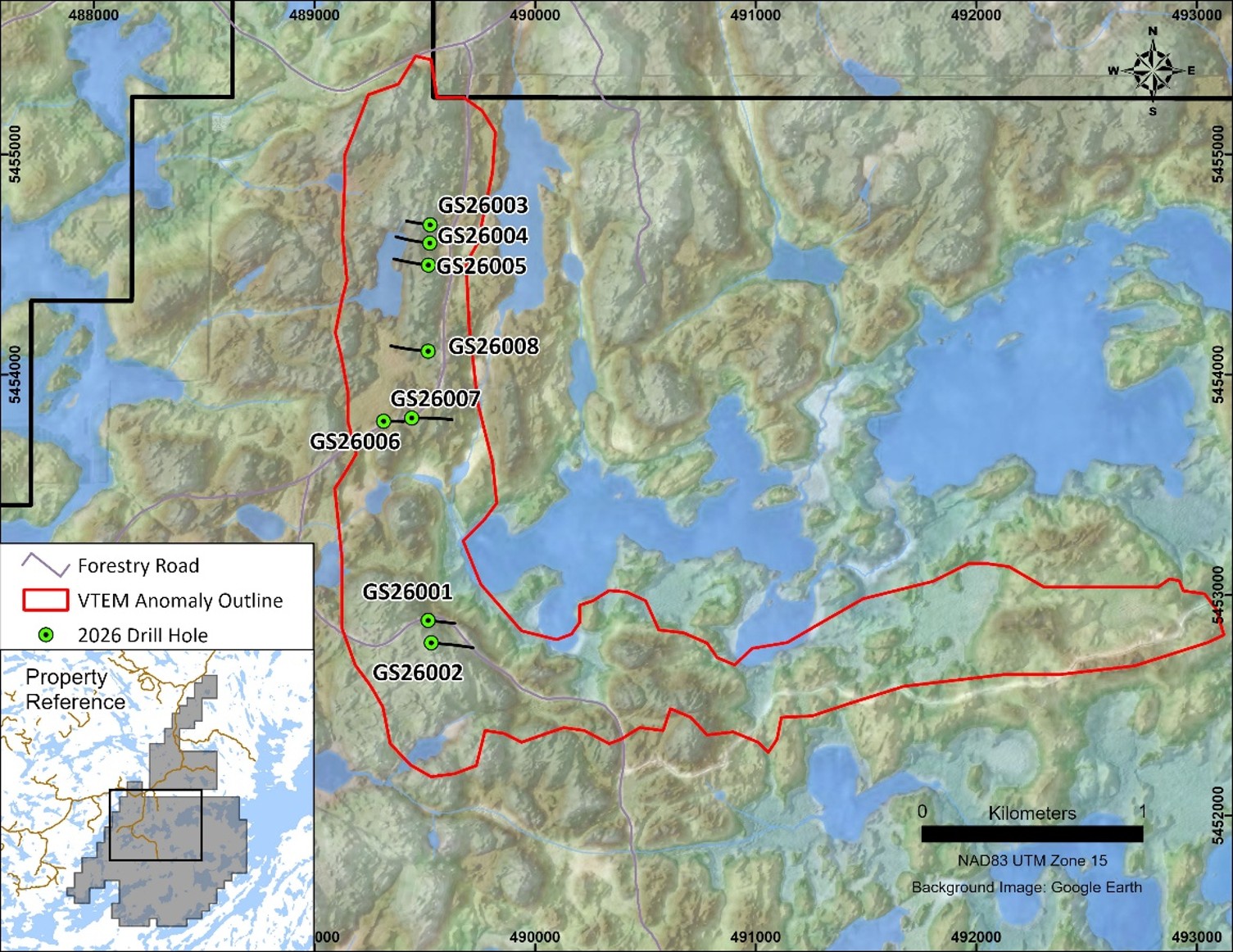
Table 1 - Drillhole Locations
Hole ID | East | North | RL (m) | Dip (d) | Azimuth | Depth (m) |
GS26001 | 489515.5 | 5452885 | 430.054 | -45 | 096 | 167 |
GS26002 | 489529.6 | 5452784 | 445.044 | -45 | 096 | 248 |
GS26003 | 489524.3 | 5454680 | 431.93 | -45 | 276 | 146 |
GS26004 | 489522.9 | 5454597 | 426.556 | -45 | 276 | 221 |
GS26005 | 489516.5 | 5454497 | 431.83 | -45 | 276 | 215 |
GS26006 | 489313.6 | 5453789 | 421.963 | -45 | 090 | 128 |
GS26007 | 489440.9 | 5453803 | 424.233 | -45 | 089 | 242 |
GS26008 | 489515.3 | 5454106 | 427.516 | -45 | 276 | 227 |
*Collar coordinates are provided in UTM 83 Zn:15. Elevations are reported as meters above sea level (RL).
Next Steps
Logging of the core has been completed, and the final holes are currently being cut for sampling.
Core samples will be analyzed at Actlabs in Thunder Bay, Ontario, which is accredited to ISO/IEC 17025 standards and operates under an ISO 9001 certified quality management system. Standard sample QA/QC procedures will be in effect.
Assay results are expected in early Q1/2027 and will be announced when they become available.
Additional mapping and ground VLF will commence in November in preparation for additional work in the spring.
About Gold Standard
The Gold Standard Project is located approximately 60km north of the city of Fort Frances and is accessible by all-weather forestry road. The property comprises 373 single cell mineral claims covering 7,869 ha and lies within the Manitou-Stormy Lakes greenstone belt along the Manitou Stretch - Pipestone Lake deformation zone, a large crustal structure that spans over 60km along its strike and up to 3km in width.
The Gold Standard Project hosts a potentially significant VMS target characterized by a conductivity anomaly 7km long and four coincident, shallow holes that were drilled by Inco in 1969 and 1970. All the drill holes intersected sulphide mineralisation; however, no assays were completed since no nickel sulphides were observed (see news release here).
Gold Standard is also home to three historical gold mines that were operational between 1901 and 1903. Surface rock samples collected by Storm in 2022 near the HW-271 mine yielded assays that included 166 g/t Au, 197 g/t Ag and 1.47% Cu (see news release here).
Qualified Person
The technical contents of this news release have been reviewed and approved by Jo Price, M.Sc., MBA, P. Geo., a Director of Storm Exploration Inc. and Qualified Person under National Instrument 43-101.
About Storm Exploration Inc.
Storm Exploration is a Canadian mineral exploration company focused on the discovery and development of economic precious and base metal deposits on three district-scale projects in northwest Ontario: Keezhik, Attwood and Gold Standard.
Forward Looking Information
This news release includes certain information that may constitute "forward-looking information" under applicable Canadian securities legislation. Forward-looking information includes, but is not limited to, the Company's strategic plans, future operations, future work programs and objectives. Forward-looking information is necessarily based upon estimates and assumptions that, while considered reasonable, are subject to known and unknown risks, uncertainties, and other factors which may cause the actual results and future events to differ materially from those expressed or implied by such forward-looking information. There can be no assurance that such information will prove to be accurate, as actual results and future events could differ materially from those anticipated in such information. Accordingly, readers should not place undue reliance on forward-looking information. All forward-looking information contained in this press release is given as of the date hereof and is based upon the opinions and estimates of management and information available to management as at the date hereof. The Company disclaims any intention or obligation to update or revise any forward-looking information, whether as a result of new information, future events or otherwise, except as required by law.
Neither the TSX Venture Exchange nor its Regulation Services Provider (as that term is defined in the policies of the TSX Venture Exchange) has reviewed or accepts responsibility for the adequacy or accuracy of this release.
On behalf of the Company,
Bruce Counts
President, CEO and Director
For further information, please contact:
Storm Exploration Inc.
T: +1 (604) 506-2804
E: bcounts@stormex.ca
SOURCE: Storm Exploration Inc.
View the original press release on ACCESS Newswire:
https://www.accessnewswire.com/newsroom/en/metals-and-mining/storm-intersects-sulphide-mineralization-in-all-eight-holes-recently-drilled-at-g-1250337