

Toronto, Ontario--(Newsfile Corp. - June 9, 2026) - First Lithium Minerals Corp. (CSE: FLM) (OTC Pink: FLMCF) (FSE: X28) ("First Lithium Minerals" or the "Company") is pleased to report the results of March 2026 sedimentary brine geochemical exploration program conducted at the Ascotan project ("Ascotan" or "Project") in the Salar de Ascotan, Antofagasta Region, Chile.
The sedimentary brine geochemical exploration program was designed on a semi-systematic grid on the concessions of the project using a portable auger drill to collect intercepted brine samples. Drilling was designed to reach standardized sampling depths between 1.0 and 1.5 meters of the sedimentary zone. The surface exploration campaign was conducted using a portable drilling rig with a 76.2 mm (3-inch) diameter auger bit. The drilling method was selected to minimize disturbance of the halite/sediment matrix and ensure the representativeness of the recovered pore fluids.
Based on the results of two previously conducted geophysical surveys, preliminary hydrogeological modelling suggests a gradually increasing brine signature starting at approximately 200 meters beneath the surface with widths up to 400 meters reaching a consolidated lacustrine base or bedrock at approximately 600 meters at depth. Highly conductive zones of less than 1.0 Ohm-meter exhibited large extent and continuity in the northeastern sectors of the Ascotan project (Ref. Press releases: "First Lithium Minerals Reports Positive Results from MT Survey", March 1, 2023, and "First Lithium Minerals Releases Results of Geophysical Surveys and Identifies Priority Targets", December 13, 2022).
A total of 40 exploratory wells were drilled, with 20 wells reaching a shallow brine table allowing the accumulation and collection of representative brine samples for assaying, with the remaining wells not intersecting the shallow brine table due to permeability conditions that would impede the flow and capture of the brine. All holes that did not intercept the brine were in the eastern sectors of the salar where geophysical interpretation suggests a deeper aquifer table. The holes intercepting and accumulating brine were primarily located in the northern, central, and southern sectors of the salar (Figure 1).
The collected brine samples were analyzed by an independent third-party certified laboratory using specific methodologies for high-density brines (ICP-OES/MS) to determine the concentrations of lithium (Li), potassium (K), magnesium (Mg), boron (B), and associated elements. The data obtained confirmed the presence of a well-defined hypersaline hydrogeochemical system, significantly enriched in lithium, potassium, and boron. The chemical characteristics are highly consistent with closed basin (endorheic) continental evaporitic environments, typical of the Andean salt flat (salar) deposits. The analyzed brine samples yielded lithium concentrations ranging from 93.5 mg/L to 1,299.5 mg/L. A high-grade group was identified in samples SAL-06, SAL-07, SAL-09, SAL-10, SAL-16, SAL-17, SAL-18, SAL-19, and SAL-20, with values exceeding 300 mg/L lithium brine concentrations. Out of those, three (3) samples reported over 1,000 mg/L lithium brine concentrations (Figure 2).
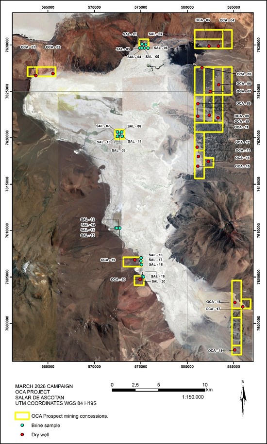
Figure 1. Location of sedimentary brine samples taken during the exploration program, March 2026
To view an enhanced version of this graphic, please visit:
https://images.newsfilecorp.com/files/3968/300698_20d133a4f4886be2_002full.jpg
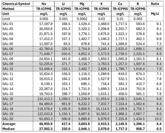
Figure 2. Sedimentary brine sample assays up to 1,299.5 mg/L Li; average 417.4 mg/L Li, exploration campaign March 2026
Note: Sedimentary brine samples are selective in nature and may not be representative of the overall mineralization or characteristics of the salar geology from which they were sampled
To view an enhanced version of this graphic, please visit:
https://images.newsfilecorp.com/files/3968/300698_firstlithiumtableimg1.jpg
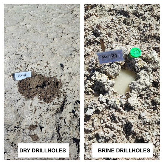
Figure 3. Sedimentary augur drill holes; dry and brine wells at 1.0-1.5 m depth, exploration campaign March 2026
To view an enhanced version of this graphic, please visit:
https://images.newsfilecorp.com/files/3968/300698_20d133a4f4886be2_004full.jpg
The geochemical data collected at the Ascotan project confirms the presence of a lithium-enriched continental brine system with a high potential within the evaluated concessions. The hydrogeochemical characteristics are exceptionally encouraging in the areas defined by samples SAL-16, SAL-17, SAL-18, SAL-19, and SAL-20, where the convergence of high lithium concentrations (>1,100 mg/L) and moderate Mg/Li ratios (8-10) reflects conditions consistent with economically viable salt flat (salar) deposits in South America.
Rob Saltsman, President & CEO of the Company, commented: "The brine samples collected from the shallow sediments using augur drill is nothing short of amazing. Over 1,100 mg/L are the highest lithium brine concentrations we have ever recorded at our project. We have always believed Ascotan is an exciting lithium exploration prospect and has geological signature and elements to become a potential future world-class lithium brine resource in Chile. Our team is excited to continue exploration work and begin test drilling as a next significant milestone."
The Company is expecting to commence a 1,500 m drilling program in H2/26, conditional upon access to capital and obtaining required government permits, licences, and community agreements.
QA/QC
A semi-systematic grid sampling program was developed within the mining concessions of the Ascotan Project, located in the Ascotan salar, in Antofagasta Region, Chile. The surface exploration campaign was conducted using a portable drilling rig with a 76.2 mm (3-inch) diameter auger bit. This drilling method was selected to minimize disturbance of the halite/sediment matrix and ensure the representativeness of the recovered pore fluids. Brine samples were selectively collected at standardized depth intervals, from 1.0 m to 1.50 m below the surface crust. To prevent evaporation, cross-contamination, or chemical alteration of the brines, the field technical team strictly followed the following sampling protocols. Sample Volume and Containment: a 100 ml aliquot of clear brine was collected from each borehole. The samples were stored in high-density polyethylene (HDPE) bottles, previously rinsed with the target brine. The bottles were filled completely (with no headspace) to minimize oxidation and potential mineral precipitation. Labeling and Thermal Preservation: each sample bottle was immediately sealed with a tamper-evident cap and labeled with a unique, sequential sample identification number. To maintain geochemical stability and suppress biological activity, the samples were stored in temperature-controlled refrigerated containers (portable coolers) at approximately 4°C during field storage and transport. Documentation and Georeferencing: the spatial coordinates of each sampling point were accurately recorded and verified using a GPS device (WGS84 datum). A complete photographic record of each site was also maintained, documenting the open pit, the recovered fluid, and the sealed sample, ensuring a complete audit for quality control and assurance purposes. Chain of Custody: the refrigerated containers remained under the strict supervision of the project geology team until their final shipment to the analytical laboratory, thus ensuring an unbroken chain of custody. The sampling was done in accordance with generally accepted industry standards and included Quality Assurance and Quality Control (QA/QC) standard elements such as including duplicate, CRM, and blank samples. Formal chain of custody documents was prepared for every sample obtained and submitted for laboratory analysis to AGS Laboratory, Avenida La Cantera 2270, Coquimbo Chile (ISO/IEC NCh17025:2017 Standard and the ISO 900:2015 Standard). In the opinion of the QP, sample preparation, security, and analytical procedures were acceptable and results from the laboratory analyses are considered adequate.
Sedimentary brine samples are selective in nature and may not be representative of the overall mineralization or characteristics of the salar geology from which they were sampled.
About the Ascotan Project
The Ascotan Project comprises approximately 1,800 ha of mineral exploration concessions located in the Salar de Ascotan in the Antofagasta Region of northern Chile. Salar de Ascotan corresponds to a classic continental closed basin 'saline salar' in the desert environment of the Andean Highlands of northern Chile, with approximately 1,757 km2 of the basin area and 243 km2 of surface area. Project area represented by soft and hard saline crusts and clay playas at the altitude of 3,716 msnm. Mineralization in the Salar de Ascotan project is primarily represented by different fractions comprised of chloride and sulfate brines, dendritic material, consisting of sand, silt and clay intercalated in the salar sediments, and various precipitated salt compounds. The project has a well-developed infrastructure and is accessed 150 km from the town of Calama, Chile via Highway 21 which runs along the western side of the salar. The railway Ferrocarril de Antofagasta a Bolivia ("FCAB") that passes through the nearby town of Ollague forms the major transportation corridor between the port city of Antofagasta, Chile and the capital city of Bolivia, La Paz. Multiple operating copper mines in the area supplement access to power grid, mining expertise, and qualified labour force. The results of two extensive geophysical surveys developed a preliminary hydrogeological model suggesting a gradually increasing brine signature starting at approximately 200 m beneath the surface with widths up to 400 m reaching a bedrock at approximately 600 m at depth. The Company received environmental approvals and signed cooperation agreement with the local indigenous community. Based on the priority drill targets assessment, the Company is planning to proceed to its inaugural brine resource exploration program in the northeastern property area of the salar. In 2024, the Chilean government through the National Lithium Strategy identified and approved Salar de Ascotan as a priority salar for lithium exploration and exploitation, aiming to strengthen Chile's position in the global lithium market.
About First Lithium Minerals
First Lithium Minerals is a Canadian mineral exploration and development company. The Company is exploring for lithium and alkali metals at its 100%-owned Ascotan Project comprised of approximately 1,800 ha of mineral exploration concessions at the Salar de Ascotan in the Antofagasta Region of northern Chile. Two property-wide geophysical surveys identified priority exploration drill targets for potential brine mineralization. The Company is currently planning its inaugural drilling program pending obtaining required permits, licences, and agreements. The Company is also exploring for gold and critical metals at its 100%-owned Lidstone Project comprised of 10,000 ha of mining claims in northwestern Ontario, Canada.
Additional information about the Company is available on the Company's website: www.firstlithium.ca
Qualified Person
Aldo Moreno Salinas is the VP of Exploration for First Lithium Minerals and the Qualified Person ("QP") as defined by National Instrument 43-101 ("NI 43-101") has reviewed and approved the technical content of this press release. Mr. Moreno is a seasoned geologist with 40 years of experience in exploration and evaluation of metallic and non-metallic mineral deposits, has a degree in geology from Universidad de Chile, is a member of the Chilean Professional Association of Geologists No. 437 and registered in the Public Records of Competent Persons No. 328.
For further information please contact:
First Lithium Minerals Corp.
40 King Street West, Suite 2400
Toronto, Ontario
M5H 3Y2
Tel: 416-402-2428
Email: rob@firstlithium.ca
Rob Saltsman, CEO and Director
Caution Regarding Forward-Looking Statements
This news release contains "forward-looking information" within the meaning of applicable securities laws. Any such forward-looking information may be identified by words such as "expects", "anticipates", "intends", "contemplates", "believes", "projects", "plans", and similar expressions. Readers are cautioned not to place undue reliance on forward-looking information. Forward-looking information is subject to known and unknown risks, uncertainties and other factors that may cause the actual results, level of activity, performance or achievements of the Company to be materially different from those expressed or implied by such forward-looking information, including but not limited to: prospecting and exploration activities, geological, geophysical, and geochemical surveys, its results and interpretation, sedimentary brine sample collection and its results geochemical and/or geological interpretation, studies and interpretations of historical exploration and geological information, drill target definition, permitting, licences, environmental laws and regulations, changes in government regulations and laws, obtaining social licence to explore and operate, community engagements, planning and timing of exploration activities, the discovery and delineation of mineral deposits/resources/reserves, general business, economic, competitive, reliance on third parties, the actual results of operations, and other risks of the natural resources industry. Although the Company has attempted to identify important factors that could cause actual results to differ materially from those contained in forward-looking information, there may be other factors that cause results not to be as anticipated, estimated or intended. The Company disclaims any obligation to update or revise any forward-looking statements information, except in accordance with applicable securities laws. Accordingly, readers should not place undue reliance on forward-looking information.
![]()
To view the source version of this press release, please visit https://www.newsfilecorp.com/release/300698
Source: First Lithium Minerals Corp.

