

Vancouver, British Columbia--(Newsfile Corp. - August 6, 2026) - NovaRed Mining Inc. (CSE: NRED) (OTCQB: NREDF) ("NovaRed" or the "Company") is pleased to report a new geological interpretation of its Wilmac Copper-Gold Project (the "Project") in British Columbia's Quesnel porphyry belt.
The interpretation is derived from surface geology, property-wide magnetic data and sub-surface data from the 2024 3DIP/AMT geophysical survey on the local Lamont grid. Together, these datasets are interpreted to suggest numerous small intrusions exposed at surface may represent the upper portions of multiple potential copper-gold porphyry systems connected to a much larger interpreted intrusive body, or batholith, at depth.
This news release is the latest in a series of technical interpretations of the Project. See the Company's news releases dated April 15, 2026 (acquisition of the historical exploration database), May 11, 2026 (historical soil geochemistry), May 13, 2026 (2024 3DIP/AMT survey, Lamont grid), June 11, 2026 (summary of results and drill target prioritization), June 17, 2026 (proposed 2026 field program), July 23, 2026 (regional magnetic interpretation) and July 24, 2026 24 (identifies large high-intensity magnetic target).
The large regional magnetic anomaly underlying the Project (see news release dated July 24, 2026) is interpreted to potentially represent a multi-phase batholith approximately 18 kilometres in diameter. More specifically, the anomaly is approximately 18 km east-northeast by west-southwest. It appears to have been segmented into three north-northwest - south-southeast domains: with the Copper Mountain domain approximately 13.1 km in length, the Whipsaw domain approximately 12.7 km and the Lamont domain approximately 8.7 km, with each domain approximately 5.7 km in width. The interpreted anomaly extends beyond the boundaries of the Project. The total area underlain by the Total Magnetic Intensity anomaly is a minimum of 188 km2, with approximately 46 km2 captured by the property. By comparison, an individual alkalic copper-gold porphyry system is typically only a few hundred metres across [RICK - source for this comparison].
This difference in scale matters for how the Project is explored. Rather than targeting the entire large magnetic anomaly, NovaRed's exploration strategy is focused on identifying the smaller intrusive "pipes" and "cupolas" extending upward from the interpreted batholith. These structures may have acted as pathways for mineral-rich hydrothermal fluids and therefore represent priority targets for copper-gold exploration.
"What changes with this interpretation is the number of things worth testing," said Brian Goss, Chief Executive Officer of NovaRed Mining Inc. "There is potentially a very large intrusive complex at depth, but the copper-gold targets we are looking for are much smaller structures extending upward from it. Across the Project we see small diorite and gabbro intrusions at surface, magnetic anomalies and pipe-like geophysical features at depth. We are not looking at a single target that either works or does not. We are looking at several spatially separate intrusive centres, each large enough that, if any one of them carries copper-gold mineralization, would be tested as its own program. That is a different risk profile from a single-target property, and it is why we have four additional geophysical surveys proposed rather than one."
How This Interpretation Relates to the Company's Previous Disclosure
The Company's geological interpretations of the Project operate at three nested scales, and the following is intended to relate them to one another. At the regional scale, total magnetic intensity data outline a composite batholith interpreted to have been segmented and vertically displaced across the Boundary and Whipsaw faults; the Project covers the western, down-dropped segments of that feature, and the Copper Mountain camp lies on the upthrown eastern block (see news release dated July 24, 2026). At the Project scale, surface mapping, drill core and geophysical survey results document a multi-phase intrusive complex comprising ultramafic, mafic and intermediate phases, interpreted to be largely unexposed (see news release dated June 11, 2026). At the survey-grid scale, the 2024 3DIP/AMT survey resolved two interpreted parent intrusive bodies beneath the Lamont grid, each with pipe-like features extending upward toward surface (see news release dated May 13, 2026).
The interpretation described in this news release proposes that these are expressions of a single intrusive system observed at different scales, and that the smaller intrusive bodies exposed at surface and imaged at the Lamont grid represent the upper levels of the larger interpreted batholith. For reference, the West Lamont Complex is another, comparatively smaller, high intensity magnetic anomaly located north of the large magnetic anomaly described above.
Within the Project, the Company has identified three high-priority areas for subsequent diamond drilling: in order of priority, the Wilmac, the Lamont / North Lamont, and the Trojan-Condor Corridor areas (see news release dated June 11, 2026). References in this news release to the Wilmac, Lamont, North Lamont, West Lamont or Plume grids are references to survey grids or target areas within the Project; references to "the Project" are to the Wilmac Copper-Gold Project as a whole.
A Large Intrusive System with Multiple Potential Targets
Small exposures of pyroxenite, hornblendite, gabbro and diorite have been mapped across the Project, and have previously been reported as evidence of a multi-phase intrusive complex identified in outcrop, in drill core and in geophysical survey results (see news release dated June 11, 2026). These rocks are interpreted as potentially representing the upper portions of a larger intrusive system rather than isolated occurrences. In the Company's geological model, magma from the deeper batholith moved upward as smaller pipes and cupolas. These structures are important because they can focus hot, metal-bearing fluids responsible for forming porphyry copper-gold deposits. This means the exploration objective at the Project is not to locate the large batholith, but rather the individual structures extending upward in which copper and gold may have become concentrated.
Geophysics Supports the Model
The historical 2024 3DIP/AMT survey on the Lamont grid (see news release dated May 13, 2026) is interpreted to provide additional support for this interpretation. The survey is interpreted to outline two parent intrusive bodies beneath the grid, each with multiple pipe-like features extending upward toward surface.
The AMT method penetrated to approximately 1,500 metres at this site. The AMT data resolved a resistivity low in the eastern portion of the grid and a resistivity high in the western portion, each comprising multiple elongated, pipe-like features near surface that coalesce downward into a single larger volume at depth. The two parent volumes interfinger with one another, a relationship interpreted to reflect two separate magmatic pulses within a composite intrusive complex. This geometry is consistent with the type of intrusive architecture expected in an alkalic porphyry copper-gold system.
The Lamont grid is small relative to the area within the tenures comprising the Project. Seven survey lines spaced 300 metres apart and ranging from 2,400 to 2,800 metres in length cover approximately 4.7 square kilometres, or approximately three percent of the Project's 16,078 hectares, and AMT data were recorded on three of the seven lines. The regional interpretation described in this news release rests principally on magnetic data; the Lamont grid is the one area of the Project in which that interpretation has been tested at depth by a three-dimensional survey. Accordingly, additional potential porphyry targets may exist elsewhere across the Project and remain untested.
Surface geochemistry provides independent support in the same area. Copper-in-soil values to a maximum of 1,125 ppm correlate broadly with the projection of near-surface chargeability highs and deeper conductivity anomalies on the eastern portion of the Lamont grid (see news releases dated May 11, 2026 and May 13, 2026). The two interpreted parent bodies correlate differently with that geochemistry: a limited number of elevayed copper-in-soil values east of the interpreted fault are spatially associated with intense chargeability anomalies, while those west of the fault are associated with chargeability lows.
Exploration Strategy: Find the Pipes
NovaRed's exploration strategy can be summarized simply: identify the structures that may have carried copper- and gold-bearing fluids upward from the larger intrusive system. Evidence for these features may include:
- Surface diorite, gabbro and related intrusive rocks;
- Copper-gold soil geochemical anomalies;
- Magnetic anomalies;
- IP chargeability anomalies; and/or
- Pipe-like features identified through AMT geophysics.
When several of these different indicators overlap, they can help define priority targets for future drilling. The Lamont grid is the clearest example on the Project to date, where copper-in-soil anomalies, chargeability highs and pipe-like resistivity features coincide. Historical drilling within the Trojan-Condor Corridor has not tested targets at depth: four holes (WS14-001 to WS14-004) totalling approximately 728 metres, were completed by a previous operator in 2014, at depths between 135 and 215 metres (see news release dated June 11, 2026). Porphyry-style alteration was encountered in those holes. Given their limited depth, that alteration is interpreted to represent peripheral alteration surrounding a target at greater depth, although this has not been tested.
Subject to receipt of the required permit and financing, the Company's proposed drilling program, which is unlikely to occur prior to 2027, would be designed to test selected targets at depths where geological and geophysical evidence suggests copper-gold mineralization could potentially be concentrated.
A District-Scale Opportunity
The Wilmac Copper-Gold Project covers 16,078 hectares within British Columbia's Quesnel porphyry belt, southwest of Princeton. The Project lies approximately 10 kilometres west of the producing Copper Mountain Mine and is separated from the Copper Mountain camp by the regional Boundary Fault.
The geological setting at the Project is potentially analogous to the broader intrusive environment associated with the Copper Mountain system, although the Project appears to expose a different and potentially shallower geological level than Copper Mountain, such that any mineralized porphyry centres, if present, would be expected at greater depth and would not be exposed at surface. Copper Mountain hosts Proven and Probable Mineral Reserves of 345 million tonnes grading 0.26% copper and 0.12 g/t gold (Hudbay Minerals Inc., "Hudbay Provides Annual Reserve and Resource Update with Mine Life Extensions and Improved Three-Year Production Outlook," news release dated March 27, 2026; mineral reserves estimated in accordance with CIM Definition Standards incorporated by reference in NI 43-101). Readers are cautioned that the discussion of mineralization, alteration or grades on adjacent, similar or analogous properties, including the Copper Mountain Mine, is not necessarily indicative of the mineralization or potential of the Project. The Company has no interest in, or right to acquire any interest in, the Copper Mountain Mine.
The combination of a large interpreted batholith, numerous intrusive exposures at surface, magnetic anomalies, geochemical anomalies and pipe-like geophysical features provides a framework for systematically exploring the Project for multiple potential alkalic copper-gold porphyry systems. Subject to financing, four proposed IP/AMT surveys across the North Lamont, West Lamont, Wilmac and Plume grids (see news release dated June 17, 2026) are intended to help determine whether similar pipe-like targets occur elsewhere within the broader interpreted intrusive complex.
Alternative Explanations
The interpretation described in this news release is conceptual, and the Company has not excluded other explanations for the datasets on which it rests. The regional magnetic anomaly may reflect a mafic or ultramafic intrusive body not associated with porphyry copper-gold mineralization. The pipe-like resistivity features imaged at the Lamont grid may reflect structural or lithological contrasts. including fault zones, graphitic horizons or saline groundwater, rather than intrusive geometry. The small intrusive exposures mapped at surface may be unrelated to the larger interpreted body at depth. Surface mapping and existing geophysical data do not distinguish among these explanations. The proposed 2026 IP/AMT surveys, and any subsequent drilling, are intended to address that question.
Qualified Person
The scientific and technical information in this news release, including the geological interpretations described herein and the accompanying figures, has been reviewed and approved by Rick Walker, P.Geo., a Qualified Person as defined by National Instrument 43-101 ("NI 43-101"). Mr. Walker is not independent of the Company within the meaning of NI 43-101. The interpretations described in this news release are conceptual, and rest in part on third-party historical mapping, geophysical surveys, soil geochemistry and drilling that the Company has not independently verified. No mineral resources or mineral reserves have been identified on the Project.
About NovaRed Mining Inc.
NovaRed Mining Inc. (CSE: NRED) (OTCQB: NREDF) is a mineral exploration company focused on the identification, acquisition, exploration and development of copper-gold porphyry projects in British Columbia, leveraging an artificial intelligence-enhanced geospatial technology platform that it developed to identify and evaluate prospective mineral properties. The Company's optioned Wilmac copper-gold project comprises 16,078 hectares located within the Quesnel porphyry belt in the Similkameen Mining Division, southwest of Princeton and approximately 10 kilometres west of Hudbay Minerals Inc.'s producing Copper Mountain Mine. For more information, visit novaredmining.com.
Readers are cautioned that discussion of mineralization, alteration or grades on adjacent, similar or analogous properties, including the Copper Mountain Mine, is not necessarily indicative of the mineralization or potential of the Wilmac Copper-Gold Project. The Company has no interest in, or right to acquire any interest in, any such properties. No mineral resources or mineral reserves have been identified on the Project.
ON BEHALF OF NOVARED MINING INC.
Brian Goss
Chief Executive Officer
E: info@novaredmining.com
FORWARD-LOOKING INFORMATION
This news release contains "forward-looking information" within the meaning of applicable Canadian securities legislation. Forward-looking information includes, but is not limited to, statements regarding: the interpretation of the regional magnetic anomaly as representing a multi-phase batholith underlying and extending beyond the Project; the interpretation that the small intrusive bodies exposed at surface, and the pipe-like features imaged by the 2024 3DIP/AMT survey on the Lamont grid, represent the upper portions of that batholith; the interpretation that such features may have focused mineralizing hydrothermal fluids and therefore represent priority exploration targets; the expectation that additional potential porphyry targets may exist elsewhere across the Project; the potential analogy between the geological setting of the Project and that of the Copper Mountain system; the Company's intention, subject to financing, to complete four IP/AMT surveys across the North Lamont, West Lamont, Wilmac and Plume grids; the Company's proposed drilling program, including its anticipated timing, design and the depths to be tested; the availability of the financing required to complete the proposed exploration on the Project; and the Company's intention and ability to satisfy the cash payment, share issuance and exploration expenditure milestones required to exercise the option agreements respecting the Project.
Forward-looking information is based on a number of assumptions that, while considered reasonable by the Company at the date of this news release, are inherently subject to significant business, economic and competitive uncertainties and contingencies. Such assumptions include, without limitation: the accuracy of current geological and geophysical interpretations, including the interpretation of the magnetic and 3DIP/AMT datasets and the deposit-model analogy described in this news release; the accuracy and completeness of the third-party historical mapping, geophysical surveys, soil geochemistry and drilling on which those interpretations rest; the availability of adequate funding to complete the proposed exploration; the ability of the Company's geophysical contractors to complete the proposed 2026 surveys on schedule; favourable weather, terrain and field conditions; access to the Project area; the availability of qualified personnel; the receipt of all necessary permits and authorizations for planned exploration, including the drill permit currently being acquired from the previous operator; and the continued cooperation of the optionors under the terms of the relevant option agreements.
Forward-looking information is subject to known and unknown risks, uncertainties and other factors that may cause actual results, performance or achievements to differ materially from those expressed or implied by such forward-looking information. Important risk factors include, but are not limited to: the possibility that the regional magnetic anomaly does not represent a multi-phase batholith; the possibility that the pipe-like features imaged at the Lamont grid reflect structural, lithological or other causes rather than intrusive geometry; the possibility that the small intrusive exposures mapped at surface are unrelated to the interpreted body at depth; the possibility that one of the alternative explanations described in this news release is correct; the possibility that the results of the proposed 2026 IP/AMT surveys do not support the interpretation described in this news release; the possibility that the geophysical surveys do not image to the depth required to test the interpretation; the possibility that the proposed drilling program is delayed, reduced in scope or not completed; the continued availability of capital and financing; the ability to satisfy option earn-in requirements on the timelines contemplated; risks inherent in mineral exploration; adverse weather or terrain conditions; tenure grant, renewal and permitting outcomes, including under British Columbia's revised mineral tenure system; Indigenous and community consultation requirements; changes in applicable laws and regulations; the ability to retain key personnel and contractors; litigation; failure of counterparties to perform their contractual obligations; and general economic, market or business conditions. Readers are cautioned not to place undue reliance on forward-looking information. The Company undertakes no obligation to update or revise any forward-looking information, except as required by applicable securities laws.
Neither the CSE nor its Market Regulator (as that term is defined in CSE policies) accepts responsibility for the adequacy or accuracy of this news release.
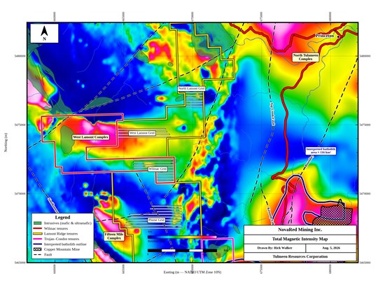
Figure 1 - Property location map. Location of the four proposed 2026 geophysical survey grids shown within the boundaries of the properties acquired by the Company. Note: does not show competitor tenures which surround the Wilmac Property.
To view an enhanced version of this graphic, please visit:
https://images.newsfilecorp.com/files/9977/308449_308b7d58f4a68b85_002full.jpg
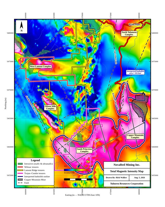
Figure 2 - Total Magnetic Intensity (TMI) map for the Wilmac Cu-Au Project and surrounding area. High resolution data acquired by previous operator plotted with respect to regional magnetic data available in the public domain. Note the segmented appearance of the intense magnetic anomaly evident to the southeast (the South Princeton and Copper Mountain Complex anomalies). Approximate east-west and north-south dimensions shown faults mapped by BC Geological Survey branch shown for reference.
To view an enhanced version of this graphic, please visit:
https://images.newsfilecorp.com/files/9977/308449_308b7d58f4a68b85_003full.jpg
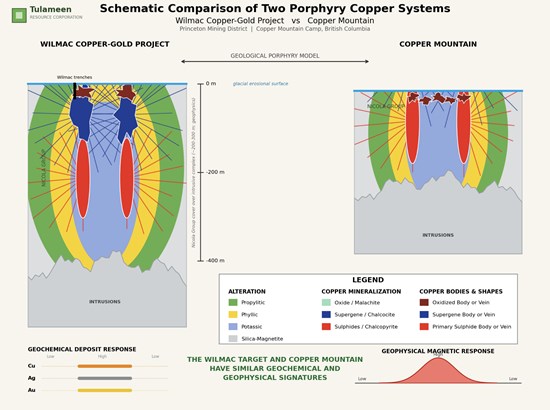
Figure 3 - Schematic comparison of the Wilmac Copper-Gold Project and Copper Mountain porphyry systems at a common erosion level, showing interpreted alteration zoning, copper mineralization styles, and the characteristic geochemical and magnetic responses, Modified from Saleken (2013).
To view an enhanced version of this graphic, please visit:
https://images.newsfilecorp.com/files/9977/308449_308b7d58f4a68b85_004full.jpg

To view the source version of this press release, please visit https://www.newsfilecorp.com/release/308449
Source: NovaRed Mining Inc.
