50m of Visually Observed Sulfide Mineralization Also Intersected at Dry Creek
Successful Summer Drill Program Complete
All Assays Pending
Vancouver, British Columbia--(Newsfile Corp. - September 8, 2026) - Silver47 Exploration Corp. (TSXV: AGA) (OTCQX: AAGAF) ("Silver47" or the "Company") is pleased to announce the completion of its summer drill program at the high-grade silver and critical minerals Red Mountain Project, Alaska (the "Red Mountain Project"). Assay results for the drill holes described in this news release are pending unless otherwise stated.
Highlights:
- Second Chance Zone - 197 m of Visually Observed Sulfide Mineralization: Initial drilling at the Second Chance zone, 43 km west of the Dry Creek deposit, intersected 197 m of visually observed continuous pyrite-sphalerite-galena mineralization (48.8 m to 245.7 m core length) in drill hole SC26-003, including a cumulative 74 m of semi-massive to massive sulfide intervals. To the Company's knowledge, based on its review of historical and current drilling records, this represents the widest mineralized interval drilled on the project to date.
- Second Chance Zone Open in All Directions: Four of five holes at Second Chance intersected the sulfide horizon over an initial 200 m of strike length and 150 m down-dip, based on visual observations. The fifth hole crossed a fault before reaching the horizon, which has since been mapped at surface on the far side of the fault. The zone is untested beyond the current drilling.
- Surface Mapping Extends Target Horizon: Preliminary geological mapping has traced the mineralized horizon at surface over a strike length of 3 km. The horizon remains open beyond the limits of this season's mapping in both directions.
- Dry Creek - 50 Meters of Visually Observed Sulfide Mineralization: Infill and step-out drilling at the Dry Creek Deposit has returned up to 50.6 m of visually observed continuous sulfide mineralization in core length, dominated by massive to semi-massive sulfide mineralization with visible sphalerite, galena and chalcopyrite.
- Drilling Complete and Assays Pending: The three-rig summer program has been completed and tested targets at Dry Creek, Second Chance, Hunter, FOMO, and WTF East.
- Mogollon Project Drilling Intersects Silver-Gold Mineralization Below the Last Chance Mine: Both holes of the winter program at Mogollon intersected epithermal silver-gold mineralization beneath the historic Last Chance mine, outside the current inferred mineral resource of 2.72 million tonnes at 367 g/t AgEq, totalling 32.08 million AgEq**.
*Notes: Red Mountain Project equivalencies are calculated using ratios with metal prices of US$2,750/tonne Zn, US$2,100/tonne Pb, US$8,880/tonne Cu, US$1,850/oz Au, and US$23/oz Ag and metal recoveries are based on metallurgical work returned of 90% Zn, 75% Pb, 70% Cu, 70% Ag, and 80% Au. Silver Equivalent (AgEq g/t) = [Zn (%) x 47.81] + [Pb (%) x 30.43] + [Cu (%) x 119] + [Ag (g/t) x 1] + [Au (g/t) x 91.93]
**Mogollon Project Silver equivalent is calculated using ratios with metal prices of US$20/oz Ag, US$1,800/oz Au with metallurgical recoveries of Ag - 90%, Au - 95%. AgEq = (Ag grade x Ag recovery)+((Au grade x Au recovery) x (Au price / Ag price)). Equivalent grades are provided for illustrative purposes only and are not intended to represent actual recoveries or payable metal.
Galen McNamara, CEO, stated: "The first drill holes at Second Chance have identified a broad zone of visually observed sulfide mineralization 43 kilometers west of the Dry Creek deposit and outside the existing Red Mountain resource footprint. At Dry Creek, visual observations from 2026 drilling have identified up to 50 meters of continuous sulfide in core length. With drilling complete, we expect a steady flow of results as assays are received. These results support our view that Red Mountain is an important silver and critical minerals project within the proposed combination with Bunker Hill."
Gary R. Thompson, Executive Chairman, stated: "The visible sulfide mineralization observed at both Second Chance and Dry Creek demonstrates the strength of the Red Mountain Project and underscores the success of this summer's drill program. As we advance our proposed merger with Bunker Hill Mining, we are bringing together complementary silver assets and creating a stronger platform for growth. We look forward to the pending assays and to advancing our combined portfolio for the benefit of shareholders."
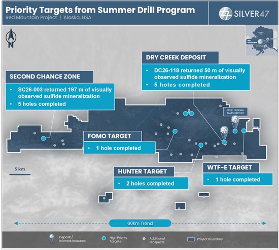
Figure 1. Plan Map of Red Mountain with Key Exploration Targets and Dry Creek Deposit
To view an enhanced version of Figure 1, please visit:
https://images.newsfilecorp.com/files/10967/313249_bfc6961694da3ad7_002full.jpg
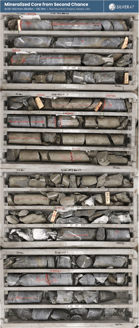
Figure 2: (see attached figure). Mineralized core from drill hole SC26-003 at the Second Chance target showing multiple pyrite-dominant massive to semi-massive sulfide intervals (128.95m to 136.79m downhole). Photo is provided for illustrative purposes only and is not intended to be representative of broader mineralization.
To view an enhanced version of Figure 2, please visit:
https://images.newsfilecorp.com/files/10967/313249_bfc6961694da3ad7_003full.jpg
Red Mountain Drill Program
The 2026 drill program at the Red Mountain Project, 100 km south of Fairbanks, Alaska, is now complete with 4,136 meters drilled across 14 drill holes. Priority volcanogenic massive sulfide (VMS) exploration targets at Red Mountain are dispersed across the highly prospective Bonnifield mining district which comprises at least 60 km of stratigraphy considered favorable for VMS mineralization.
Three drill rigs focused on five priority targets - Dry Creek, Second Chance, Hunter, WTF-E and FOMO. Program highlights include:
- Drilling at the Second Chance zone (formerly known as Sheep Creek), 43 km west of the Dry Creek deposit, tested a ~200m portion of an east-west trending target horizon hosted in metasediments. Five drill holes (SC26-001, SC26-002, SC26-003, SC26-004, and SC26-005) have now been completed including:
- Drill hole SC26-001 (azimuth 150°, dip -50°, total depth 216.6 m), intersected a 66.8 m mineralized interval from 78.4 m to 145.2 m core length of disseminated to banded pyrite and sphalerite. The interval includes 10.7 m of intermittent to massive sulfide banding from 85.6 m to 96.3 m, visually estimated at 10 to 45% pyrite, and a discrete massive sulfide unit from 139.9 m to 145.2 m containing two zones visually estimated at approximately 90% pyrite with sphalerite and banded galena. An upper zone of sphalerite-bearing schist was also intersected from 48.0 m to 59.5 m. The hole ended in a fault zone and the mineralized interval remains open at depth.
- Drill hole SC26-002, collared from the same pad as SC26-001 and drilled to the south-southwest (azimuth 190°, dip -45°, total depth 250.2 m), intersected two zones of sulfide mineralization. The upper zone, from 107.0 m to 148.6 m core length (41.6 m), consists of replacement-style pyrite-sphalerite-galena mineralization in silicified quartzite and metaconglomerate with semi-massive to massive sulfide bands, including 1.0 m from 130.8 m visually estimated at 40 to 45% pyrite, 5 to 7% sphalerite and 1 to 2% galena, and 1.2 m of massive sulfide from 147.4 m visually estimated at approximately 95% pyrite with sphalerite. A further 2.7 m massive sulfide interval from 175.9 m to 178.6 m is visually estimated at approximately 90% pyrite with 1 to 10% sphalerite and trace galena. The lower zone, from 195.5 m to 220.7 m (25.1 m), consists of semi-massive sulfide in gray quartzite, including 20.0 m visually estimated at 35% pyrite and 10% sphalerite. The hole ended in black phyllite.
- Drill hole SC26-003, collared from a second pad to the west (azimuth 129°, dip -62°, total depth 259.1 m), intersected a continuous zone of silicified, sulfide-bearing quartzite from 48.8 m to 245.7 m core length (196.9 m), hosted within a broader black graphitic phyllite sequence, before ending in weakly altered phyllite. Sulfide mineralization (pyrite-sphalerite-galena) is present as disseminations, stringers and veins throughout the silicified quartzite package and includes a cumulative 74 m of semi-massive to massive sulfide intervals, with several intervals visually estimated at up to 70% pyrite, 25% sphalerite and 2% galena. To the company's knowledge, SC26-003 represents the widest mineralized intersection drilled to date at Red Mountain.
- Drill hole SC26-004 was drilled to the south (azimuth 195°, dip -45°, total depth 304.8 m) from the SC26-003 pad. The hole crossed a fault and intersected graphitic phyllite with weak pyrite and trace sphalerite but did not intersect the mineralized quartzite horizon. Subsequent mapping has traced the horizon at surface on the far side of the fault, where it remains untested by drilling.
- Drill hole SC26-005, the final hole of the 2026 program, was drilled to the east-southeast (azimuth 105°, dip -56°, total depth 307.8 m) from the SC26-003 pad and intersected sulfide-bearing silicified gray quartzite from 43.9 m to 139.9 m core length (96.0 m). Sulfide mineralization is present throughout the interval as disseminations, stringers and veins, visually estimated at 1 to 30% pyrite and 1 to 20% sphalerite with minor galena, The silicified grey quartzite includes multiple semi-massive to massive sulfide intervals ranging between < 1m and 5m of core length. A further 4.6 m of pyrite-sphalerite mineralization (20% pyrite, 5% sphalerite) was intersected in graphitic phyllite from 222.2 m, immediately above a fault gouge zone. The mineralized quartzite in SC26-005 correlates with the horizon intersected in SC26-003.
- Drilling at Dry Creek was designed to further delineate and expand the Dry Creek deposit (inferred mineral resource of 11.6 million tonnes at 279.4 g/t AgEq, totalling 104.0 million silver equivalent ounces*, Table 1). Each hole served two purposes: infilling the modelled mineralized zones and stepping out into undrilled stratigraphy above and below those zones that is not included in the current mineral resource estimate. Five drill holes, DC26-115, DC26-116, DC26-117, DC26-118 and DC26-119, were drilled planned to investigate the orientation and structural controls on higher-grade VMS mineralization. All five holes intersected visually observed broad zones of massive, semi-massive and disseminated sulfide within pyritic metavolcanics and metasediments of the Totatlanika Schist. DC26-118 intersected 50.6 m of visually observed continuous sulfide mineralization in core length, of which approximately 34 m is massive to semi-massive sulfide, including a 12.8 m massive sulfide horizon containing pyrite, sphalerite, galena and chalcopyrite.
- Drilling at the Hunter target, 5.8 km west of the Dry Creek deposit (Figure 1) targeted the extent of silver-rich massive sulfide mineralization which has been traced for over 500 m. Rock chip sampling of the discovery outcrop returned assays up to 616 g/t Ag, 18.6% Zn, 5.4% Pb, 2.5% Cu, and 0.33 g/t Au. Six drill holes in 2018, 2019 and 2021 successfully tested the dip-extent of the massive sulfide horizon highlighted by 1.4 m of 17.4% Zn, 3.9% Pb, 1.6% Cu, 90 g/t Ag and 0.23 g/t Au (HR18-01)1 and 1.8 m of 13.8% Zn, 3.1% Pb, 56 g/t Ag, 0.2 g/t Au and 0.9% Cu (HR18-02)1. Two drill holes, HR26-008 and HR26-009, have been completed and intersected local zones of massive sulfides.
- Drilling at the WTF East target, 5.0 km northeast of the Dry Creek deposit (Figure 1), targeted the potential eastern faulted offset of the West Tundra Flats deposit, which hosts an inferred mineral resource of 4.0 million tonnes at 496.9 g/t AgEq, totaling 64.6 million silver equivalent ounces1. WTF East was identified as a high-priority exploration target based on a previously untested EM conductor located in a position considered consistent with a faulted offset of the known West Tundra Flats mineralization. One drill hole, WTE26-001, tested the EM conductor and intersected visually observed local sulfide mineralization, with pyrite, sphalerite and chalcopyrite stringers increasing downhole and a narrow galena-chalcopyrite-bearing zone at 139.5 m downhole.
- Drilling at the FOMO target, 10 km west of the Dry Creek deposit (Figure 1), targeted the extent of semi-massive to massive sulfide mineralization discovered in 2025. Mineralization at FOMO is hosted within the Sheep Creek Member of the Totatlanika Schist, towards the center of the Dry Creek syncline, with sulfides consisting of sphalerite, galena, chalcopyrite and pyrite occurring across 0.5 m to 5 m wide zones. Rock sampling at FOMO returned assays of up to 1,792 g/t AgEq, including 74 g/t Ag, 2.54% Cu, 10.05% Pb and 23.20% Zn. One drill hole, FO26-001, evaluated the FOMO target and intersected visually observed local sulfide mineralization including a narrow interval of strong pyrite, galena, and chalcopyrite at 57 m downhole.
Project-scale exploration focused on drill target generation across the entire Red Mountain Project area is also now complete. The program consisted of detailed geological and structural mapping across key target areas together with prospecting and soil geochemical surveys.
*Table 1: Combined Open Pit and Underground Inferred Mineral Resource Estimate for the Red Mountain Project, Alaska
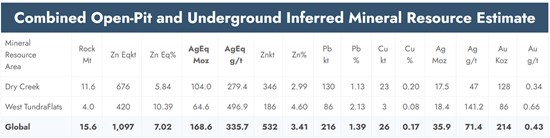
To view an enhanced version of Table 1 please visit:
https://images.newsfilecorp.com/files/10967/313249_bfc6961694da3ad7_004full.jpg
- The 2024 Red Mountain Mineral Resource Estimate was estimated and classified in accordance with the Canadian Institute of Mining, Metallurgy and Petroleum ("CIM") "Estimation of Mineral Resources and Mineral Reserves Best Practice Guidelines" dated November 29, 2019, and the CIM "Definition Standards for Mineral Resources and Mineral Reserves" dated May 10, 2014.
- Mr. Warren Black, M.Sc., P.Geo. of APEX Geoscience Ltd., a QP as defined by National Instrument 43-101 - Standards of Disclosure for Mineral Projects ("NI 43-101"), is responsible for completing the 2024 Mineral Resource Estimate, effective January 12, 2024.
- Mineral resources that are not mineral reserves have not demonstrated economic viability. No mineral reserves have been calculated for Red Mountain. There is no guarantee that any part of the mineral resources discussed herein will be converted to a mineral reserve in the future.
- The estimate of mineral resources may be materially affected by environmental, permitting, legal, title, market, or other relevant factors.
- The quantity and grade of reported Inferred Resources is uncertain, and there has not been sufficient work to define the Inferred Mineral Resource as an Indicated or Measured Mineral Resource. It is reasonably expected that most of the Inferred Mineral Resources could be upgraded to Indicated Mineral Resources with continued exploration.
- All figures are rounded to reflect the relative accuracy of the estimates. Totals may not sum due to rounding. Reported grades are undiluted.
- A standard density of 2.94 g/cm³ is assumed for mineralized material and waste rock. Overburden density is set at 1.8 g/cm³. For mineralized material blocks with iron assays close enough to estimate an iron value for the block, density is calculated using the formula: density (g/cm³) = 0.0553 * Fe (%) + 2.5426.
- Metal prices are US$2,750/tonne Zn, US$2,100/tonne Pb, US$8,880/tonne Cu, US$1,850/oz Au, and US$23/oz Ag.
Mogollon Winter Drill Program
Silver47 also reports assay results from its winter drill program at the high-grade silver-gold Mogollon Project, New Mexico (the "Mogollon Project"). The program consisted of two drill holes designed to evaluate the depth extent of high-grade silver mineralization below the Last Chance mine, centered on the +2.5 km, east-west trending Last Chance Vein near the South Queen target (Figure 3). Mineralization along the Last Chance vein is currently outside of the Mogollon Inferred Mineral Resource of 32.08 Moz silver equivalent (12.12 Moz silver and 0.24 Moz gold) at 367 g/t silver equivalent* (139 g/t silver and 2.72 g/t gold) within 2.72 Mt2. Mineral resources are not mineral reserves and do not have demonstrated economic viability. Inferred mineral resources are uncertain in nature and there has not been sufficient work to define them as indicated or measured mineral resources.
Mineralization at the Last Chance Mine is interpreted to plunge to the east, towards the intersection with the significant north-south trending Queen Vein (Figure 3). The drill holes tested the depth extent of high-grade silver-gold mineralization towards the modelled vein intersection. Both holes intersected zones of epithermal-related silver-gold mineralization (e.g., 303 g/t silver equivalent (117 g/t Ag, 2.31 g/t Au) over 0.3 m, MOG26-23, Table 2) interpreted to represent un-mined mineralization associated with the Last Chance vein system. Further drilling to investigate potential structural offsets and/or cross faults towards the Queen Vein is being evaluated to better define the structural controls and orientations of vein sets along the South Queen target.
Table 2: Assay Results
| Drill Hole | From (m) | To (m) | Length (m) | Au (g/t) | Ag (g/t) | AgEq* (g/t) |
| MOG26-23 | 418.80 | 419.10 | 0.3 | 2.31 | 117 | 303 |
| MOG26-24 | 395.03 | 396.74 | 1.7 | 1.20 | 73.8 | 169 |
* g/t = grams per tonne; Silver equivalent is calculated using ratios with metal prices of US$20/oz Ag, US$1,800/oz Au with metallurgical recoveries of Ag - 90%, Au - 95%. AgEq = (Ag grade x Ag recovery)+((Au grade x Au recovery) x (Au price / Ag price)).
Table 3: Collar Information
| Target Area | Hole ID | Easting | Northing | Azimuth | Dip | Final Depth (m) |
| Last Chance | MOG26-0023 | 704180 | 3697231 | 134 | -44 | 542.5 |
| Last Chance | MOG26-0024 | 704180 | 3697231 | 143 | -52 | 457.8 |
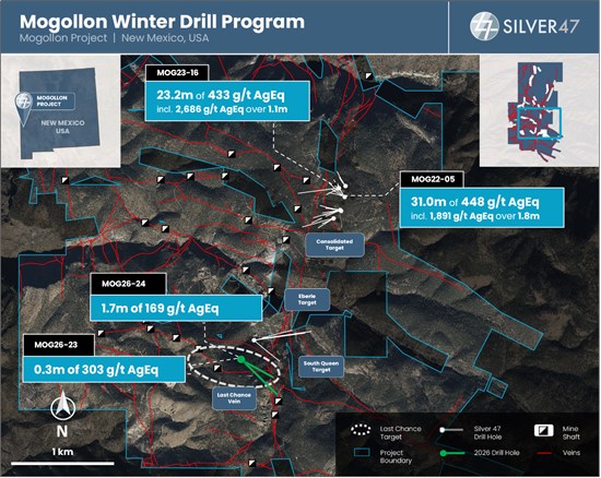
Figure 3: Plan Map of Mogollon Project
To view an enhanced version of Figure 3, please visit:
https://images.newsfilecorp.com/files/10967/313249_bfc6961694da3ad7_005full.jpg
Quality Assurance and Quality Control
Quality assurance and quality control (QAQC) protocols for drill core sampling at the Red Mountain Project followed industry standard practices. Core samples were typically taken at 1.0 m intervals in mineralized zones, and 3.0 m intervals outside of mineralized zones. Sample lengths were adjusted as necessary so as not to cross lithologic and mineralogic boundaries. QAQC check samples were inserted into the sample stream with one blank, one duplicate (coarse), and one certified reference material (CRM) occurring within every 20 samples. Drill core was cut in half, bagged, sealed and delivered directly to ALS Minerals Fairbanks, Alaska for transport to the ALS Minerals Laboratories labs in North Vancouver, British Columbia. ALS Minerals Laboratories are registered to ISO 9001:2008 and ISO 17025 accreditations for laboratory procedures. Core samples were analyzed at ALS Laboratory facilities in North Vancouver using four-acid digestion with an ICP-MS finish. Gold analysis was by fire assay with atomic absorption finish, or gravimetric finish for over-limit samples. Over-limits for silver, zinc, copper, and lead were analyzed using Ore Grade four-acid digestion. The standards, certified reference materials, were acquired from CDN Resource Laboratories Ltd. of Langley, British Columbia and selected to represent expected mineralization.
Drill core was sawn in half at Silver47's core logging and processing facilities at the Mogollon Project. All core samples were sent to Paragon Geochemical Laboratories in Sparks, Nevada for preparation and analysis. Paragon meets all requirements of the International Accreditation Service AC89 and demonstrates compliance with ISO/IEC Standard 17025:2017 for analytical procedures. Samples were analyzed for gold via fire assay with an AA finish and samples that assayed over 8 ppm were re-run via fire assay with a gravimetric finish. Silver and trace elements were analyzed via inductively coupled plasma mass spectroscopy after four-acid digestion. Samples that assayed over 100 ppm Ag were re-run via fire assay for Ag with a gravimetric finish. In addition to Paragon quality assurance / quality control ("QA/QC") protocols, Silver47 implements an internal QA/QC program that includes the insertion of sample blanks, duplicates and certified reference materials at systematic and random points in the sample stream.
Technical Disclosure
The scientific and technical information contained in this news release has been reviewed and approved by Galen McNamara, P.Geo., CEO of the Company, who is a Qualified Person as defined in National Instrument 43-101 - Standards of Disclosure for Mineral Projects.
Historical and prior exploration results referenced in this news release have not been independently verified by the Company except as expressly stated. The Company considers this information relevant for geological context and exploration targeting purposes, but readers should not place undue reliance on such historical information.
Photographs of drill core are provided for illustrative purposes only. Visual estimates of mineralization are inherently imprecise and may not accurately reflect true grade. Readers are cautioned that photographic representations of mineralization should not be relied upon as a substitute for analytical assay results and do not represent the average grade of any sample interval.
Visual observations of sulfide mineralization disclosed in this news release are preliminary in nature and are not necessarily indicative of grade, continuity or the potential to define a mineral resource. Assay results are pending unless otherwise stated.
References
(1) Raffle, K, Livingston, C., Proenza, Y. and Black, B., 2024, "Technical Report on the Red Mountain VMS Property, Bonnifield Mining District, Alaska, USA", dated June 28, 2024 with an effective date of January 12, 2024, 200 p, prepared for the Company by Apex Geoscience Ltd., SEDAR+ (www.sedarplus.ca).
(2) Bourque, S., and Bickel, J., 2025, "NI 43-101 Technical Report on Mineral Resources at the Mogollon Silver-Gold Property, Catron County, New Mexico, USA", dated March 2, 2025 with an effective date of November 22, 2024, SEDAR+ (www.sedarplus.ca) (the "Mogollon Technical Report").
About Silver47 Exploration
Silver47 Exploration Corp is a mineral exploration company, focused on uncovering and developing silver-rich deposits in North America. The Company is creating a leading high-grade US-focused silver developer with a resource totaling 236 Moz AgEq at 334 g/t AgEq inferred and 10 Moz at 333 g/t AgEq indicated. With operations in Alaska, Nevada and New Mexico, Silver47 Exploration is anchored in America's most prolific mining jurisdictions. For detailed information regarding the resource estimates, assumptions, and technical reports, please refer to the NI 43-101 Technical Report and other filings available on SEDAR at www.sedarplus.ca. The Company trades on the TSXV under the symbol AGA and OTCQX under the symbol AAGAF.
For more information about the Company, please visit www.silver47.ca and see the Technical Report filed on SEDAR+ (www.sedarplus.ca) and titled "Technical Report on the Red Mountain VMS Property Bonnifield Mining District, Alaska, USA with an effective date January 12, 2024, and prepared by APEX Geoscience Ltd."
Follow us on social media for the latest updates:
- X: @Silver47co
- LinkedIn: Silver47
On Behalf of the Board of Directors
Mr. Galen McNamara
CEO & Director
For investor relations
Giordy Belfiore
604-288-8004
gbelfiore@silver47.ca
Neither the TSXV nor its Regulation Services Provider (as that term is defined in the policies of the TSXV) accepts responsibility for the adequacy or accuracy of this release.
FORWARD-LOOKING STATEMENTS
Certain statements contained in this news release constitute forward-looking statements or forward-looking information under applicable securities laws (collectively, "forward-looking statements"). Such statements relate to future events or the Company's future plans, performance, business prospects or opportunities that are based on forecasts of future results, estimates of amounts not yet determinable and assumptions of management. Any statements that express or involve discussions with respect to predictions, expectations, beliefs, plans, projections, objectives, assumptions or future events or performance (often, but not always, using words or phrases such as "anticipate", "believe", "estimate", "expect", "intend", "plan", "potential", "could", "may", "will" and similar expressions) are not statements of historical fact and may be forward-looking statements.
Forward-looking statements in this news release include, but are not limited to: the interpretation of exploration results, visual observations, historical and prior exploration data and geological and geophysical information; the significance of drill results and visual observations; the timing and receipt of pending assay results; the potential for additional mineralization; the potential for mineralized zones to remain open or continue beyond current drilling; the timing and success of future exploration activities, including drilling and sampling; the ability to expand or upgrade mineral resources through further exploration; the potential for future economic studies on the project; the proposed combination with Bunker Hill and the expected role of Red Mountain following completion; and the Company's plans and objectives in advancing its exploration properties.
These forward-looking statements are based on a number of assumptions considered reasonable by management as of the date of this news release, including assumptions regarding: the accuracy of geological interpretations; continuity of mineralization; the Company's ability to obtain necessary permits and approvals; availability of financing and personnel to carry out planned programs; future commodity prices; and general business and economic conditions.
Forward-looking statements are inherently subject to known and unknown risks, uncertainties and other factors that may cause actual results to differ materially from those expressed or implied. Such risks include, but are not limited to: risks inherent in mineral exploration, including unexpected results or outcomes; risks that visual observations of mineralization may not be confirmed by assay results and may not be indicative of grade, continuity or the potential to define a mineral resource; delays or inability to obtain required permits and approvals; availability and cost of financing, labour and equipment; changes in commodity prices and foreign exchange rates; political, regulatory and environmental risks in the jurisdictions where the Company operates; community or social risks; risks relating to completion and anticipated benefits of the proposed combination with Bunker Hill; and other risks described in the Company's continuous disclosure documents filed at www.sedarplus.ca.
Although the Company believes the expectations expressed in such forward-looking statements are reasonable, no assurance can be given that these expectations will prove to be correct and such statements should not be unduly relied upon. Forward-looking statements speak only as of the date of this news release. The Company does not undertake any obligation to update or revise any forward-looking statements, except as required by applicable securities laws. Actual results may differ materially from those expressed or implied in forward-looking statements.

To view the source version of this press release, please visit https://www.newsfilecorp.com/release/313249