- New Battle Mountain high-grade zone highlighted by 24.3 m @ 10.14 g/t Au, including 4.6 m @ 51.84 g/t Au from 181.4m downhole, now integrated into district-scale model
- Six new 2026 drill holes integrated into a 3D model incorporating more than 40,000 m of historical and current drilling across the 10,100-acre Tuscarora District
- Additional results from six Phase 1 holes pending; inaugural Tuscarora mineral resource estimate planned for Q1 2027
Vancouver, British Columbia--(Newsfile Corp. - October 6, 2026) - ICG Silver & Gold Ltd. (CSE: ICG) (FSE: JI0) (OTC Pink: ICGSF) ("ICG" or the "Company") is pleased to announce that it has updated its interactive VRIFY presentation with the results received to date from the first six holes of the Phase 1 Drill Program at the Company's Tuscarora District Project ("Tuscarora" or the "District") in Elko County, Nevada.
As announced on September 30, 2026, the Company released results from the first six drill holes at the Silica and Battle Mountain targets. All six Reverse Circulation ("RC") holes intersected gold and/or silver mineralization. Most significantly, drilling identified a new high-grade gold zone at the Battle Mountain target highlighted by an intersection of 24.3 meters of 10.14 grams per tonne ("g/t") gold and 3.4 g/t silver, while also providing additional information on the broader, lower-grade mineralized system surrounding it.
With these new updates, investors can now visualize and interact with 1,482 additional meters of data and see how the Battle Mountain and Silica targets relate to the entire 10,100-acre District that the Company now controls. For a general project overview, see Figures 1 and 2, and more detail on the Battle Mountain target in Figure 3.
WATCH THE VRIFY VIDEO HERE: https://youtu.be/qsPQoi7yA0I
Cannot view this video? Visit:
https://www.youtube.com/watch?v=qsPQoi7yA0I
"The updated 3D model allows investors to visualize the significance of our new Battle Mountain high-grade zone (24.3 meters grading 10.14 g/t gold) in relation to surrounding drilling, historical exploration and the broader Tuscarora District. Importantly, the model demonstrates how our modern drilling is being integrated with more than 40,000 meters of historical data to refine our geological interpretation," said Steven Sirbovan, President and CEO of ICG.
The VRIFY presentation allows prospective and current investors to:
- Explore the geological model in three dimensions
- Visualize more than approximately 40,000 meters of drilling combining initial results from the Phase 1 Drill Program and drilling by previous operators
- Better understand the district-scale exploration opportunity at the Tuscarora District.
Management believes the updates to the geological model and the VRIFY presentation represent important milestones in advancing the Tuscarora District to support systematic exploration and future discovery. The Company will continue refining the model as new geological information and drill results become available from the remainder of the Phase 1 Drill Program, expected in a few weeks. As reported previously, the Company is planning to announce the first mineral resource estimate for the Tuscarora District in Q1 2027.
Drilling Highlights Added to VRIFY Model (see Table 1)
- T26RC-04 intersected 24.3 meters of 10.14 grams per tonne ("g/t") gold ("Au") and 3.4 g/t silver ("Ag") from 181.4 meters downhole, including:
- 12.1 meters of 20.00 g/t Au and 4.7 g/t Ag;
- 9.1 meters of 26.58 g/t Au and 5.8 g/t Ag;
- 4.6 meters of 51.84 g/t Au and 10.2 g/t Ag; and
- 1.5 meters of 137.0 g/t Au and 25.7 g/t Ag.
- Additional mineralized intervals in T26RC-04 include:
- 6.10 meters of 1.75 g/t Au and 7.0 g/t Ag, including 1.52 meters of 5.13 g/t Au and 14.8 g/t Ag;
- 13.7 meters of 1.23 g/t Au and 3.5 g/t Ag, including 4.6 meters of 2.95 g/t Au; and
- 1.52 meters of 0.20 g/t Au and 22.8 g/t Ag.
- T26RC-05 intersected 15.2 meters of 0.73 g/t Au and 2.2 g/t Ag from 224.0 meters downhole, including:
- 7.6 meters of 1.27 g/t Au;
- 3.1 meters of 2.30 g/t Au and 1.8 g/t Ag; and
- 1.5 meters of 3.20 g/t Au and 2.3 g/t Ag.
- 6.1 meters of 10.5 g/t Ag, including individual 1.5-meter samples of up to 20.1 g/t Ag.
"Putting the Battle Mountain results into three dimensions provides important context for what we encountered in our first program at this target," said Korbon McCall, VP Exploration of ICG. "The high-grade intercept in T26RC-04, together with the broader mineralized intervals in surrounding drilling, gives us valuable information on the geometry and structural controls of the system as we refine follow-up targets around the new high-grade zone and across the broader district."
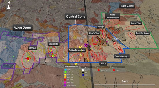
Figure 1: Updated overview of the Tuscarora District.
To view an enhanced version of this graphic, please visit:
https://images.newsfilecorp.com/files/12036/317598_9a1c5421e4522ad0_001full.jpg
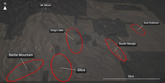
Figure 2: Updated overview of historical and recent drill traces across the Central and East Zone.
To view an enhanced version of this graphic, please visit:
https://images.newsfilecorp.com/files/12036/317598_9a1c5421e4522ad0_002full.jpg
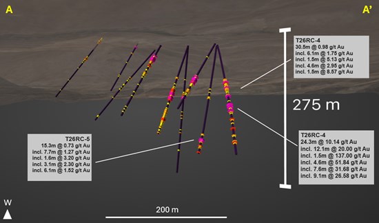
Figure 3: Historical drill database along with three new holes from Phase 1 Drill Program at the Battle Mountain target.
To view an enhanced version of this graphic, please visit:
https://images.newsfilecorp.com/files/12036/317598_9a1c5421e4522ad0_003full.jpg
Table 1: 2026 Phase 1 Drill Program Batched Drill Highlights Added to VRIFY Model
| Drill Hole ID | From (m) | To (m) | Interval (m) | Au (g/t) | Ag (g/t) |
| T26RC-1 | 73.2 | 76.2 | 3.1 | 0.24 | 2.5 |
| including | 73.2 | 74.7 | 1.5 | 0.40 | 2.6 |
| T26RC-2 | 111.3 | 112.8 | 1.5 | 0.24 | 2.9 |
| and | 184.4 | 185.9 | 1.5 | 0.39 | 2.1 |
| T26RC-3 | 140.2 | 143.3 | 3.1 | 0.21 | 10.3 |
| including | 140.2 | 141.7 | 1.5 | 0.28 | 14.6 |
| T26RC-4 | 117.3 | 147.8 | 30.5 | 0.98 | 3.5 |
| including | 123.4 | 129.5 | 6.1 | 1.75 | 7.0 |
| including | 125.0 | 126.5 | 1.5 | 5.13 | 14.8 |
| including | 140.2 | 141.7 | 1.5 | 8.57 | 3.4 |
| including | 138.7 | 143.3 | 4.6 | 2.95 | 2.9 |
| and | 181.4 | 205.7 | 24.3 | 10.14 | 3.4 |
| including | 181.4 | 193.5 | 12.1 | 20.00 | 4.7 |
| including | 182.9 | 192.0 | 9.1 | 26.58 | 5.8 |
| including | 182.9 | 190.5 | 7.6 | 31.68 | 6.7 |
| including | 182.9 | 187.5 | 4.6 | 51.84 | 10.2 |
| including | 182.9 | 184.4 | 1.5 | 137.00 | 25.7 |
| and | 227.1 | 228.6 | 1.5 | 0.20 | 22.8 |
| T26RC-5 | 115.8 | 121.9 | 6.1 | 0.07 | 10.5 |
| including | 115.8 | 117.4 | 1.5 | 0.03 | 18.4 |
| including | 118.9 | 120.4 | 1.5 | 0.10 | 20.1 |
| and | 131.1 | 132.6 | 1.5 | 0.23 | 15.8 |
| and | 224.0 | 239.3 | 15.2 | 0.73 | 2.2 |
| including | 224.0 | 231.7 | 7.6 | 1.27 | 1.3 |
| including | 224.0 | 230.1 | 6.1 | 1.52 | 1.4 |
| including | 224.0 | 227.1 | 3.1 | 2.30 | 1.8 |
| including | 224.0 | 225.6 | 1.5 | 3.20 | 2.3 |
| T26RC-6 | 117.4 | 118.9 | 1.5 | 0.36 | 0.4 |
| and | 128.0 | 131.1 | 3.1 | 0.20 | 0.6 |
Notes: m = meters; Au = gold; Ag = silver; g/t = grams per tonne; Sufficient work has not been completed to determine true widths for the intervals reported. All intervals are reported as depth of sample.
Table 2: 2026 Phase 1 Drill Program Drill Hole Location Data Added to VRIFY Model
| Drill Hole ID | Easting (NAD83 UTM) | Northing (NAD83 UTM) | Elevation (m) | Azimuth | Dip | Total Depth (m) |
| T26RC-1 | 562935 | 4571847 | 1872 | 060 | 55 | 242.3 |
| T26RC-2 | 562828 | 4571909 | 1822 | 220 | 84 | 213.4 |
| T26RC-3 | 562845 | 4571836 | 1873 | 137 | 76 | 219.5 |
| T26RC-4 | 562056 | 4572097 | 1895 | 085 | 45 | 294.1 |
| T26RC-5 | 562053 | 4572096 | 1902 | 110 | 65 | 254.5 |
| T26RC-6 | 561918 | 4571955 | 1907 | 135 | 45 | 259.1 |
| T26RC-7 | 563290 | 4573014 | 1910 | 080 | 55 | 256.0 |
| T26RC-8 | 566282 | 4574249 | 1842 | 090 | 73 | 213.4 |
| T26RC-9 | 566281 | 4574255 | 1842 | 030 | 67 | 298.7 |
| T26RC-10 | 566287 | 4574253 | 1838 | 120 | 65 | 274.6 |
| T26RC-11 | 566345 | 4574097 | 1825 | 090 | 50 | 274.3 |
| T26RC-12 | 566341 | 4574100 | 1828 | 027 | 62 | 248.4 |
Note: Coordinate Reference System (CRS): NAD83 / UTM Zone 11N.
Initial results from the 2026, 3,000-meter Phase 1 Drill Program show T26RC-04 intersected a newly identified high-grade shoot highlighted by 24.3 meters of 10.14 g/t gold and 3.4 g/t silver, including 12.1 meters of 20.00 g/t gold and 4.7 g/t silver, 4.6 meters of 51.84 g/t gold and 10.2 g/t silver, and 1.52 meters of 137.0 g/t gold and 25.70 g/t silver.
As showcased by the VRIFY presentation, the location of this high-grade shoot supports the Company's structural modeling approach, which was used to refine drill targeting and identify structural intersections favorable for concentrated gold-silver mineralization. The broader mineralized intervals across the six holes also provide additional information on the distribution and continuity of the surrounding lower-grade mineralized system.
The Company is not aware of any drilling, sampling, recovery, or other factors that could materially affect the accuracy or reliability of the results disclosed.
Quality Assurance / Quality Control
Samples were collected under the supervision of Company personnel, securely sealed and transported under chain-of-custody procedures to ALS Global Laboratories in Elko, Nevada, for sample preparation and analysis. ALS Global Laboratories is independent of the Company.
The Tuscarora District Phase 1 Drill Program drill samples were collected at 1.5-meter (5-foot) intervals. Samples were prepared using the ALS PREP-31Y package, where the sample is crushed to a target of 70% passing 2 millimeters, a 250-gram subsample is obtained using a rotary splitter, and the subsample is pulverized to a target of 85% passing 75 microns.
Gold was analyzed using the Au-GRA21 package consisting of a 30-gram fire assay with a gravimetric finish. Multi-element analysis is performed using ME-MS61, a four-acid digestion with an ICP-MS finish that provides near-total recovery for a suite of 48 elements.
The Company's quality assurance and quality control program requires regular inserts of certified reference materials, blanks, and duplicate samples into the sample stream. Company personnel review and validate analytical results and laboratory quality-control data before public disclosure.
The Company will publish results from the remainder of the Phase 1 Drill Program once it has received and interpreted the data and completed its quality assurance and quality control procedures.
Disclosure on Historical Sampling Data
Figures shown include historical data and data collected by the Company. Various operators conducted historical sampling programs, which may not meet current QA/QC standards as defined under National Instrument 43-101. The Company has not verified all historical sampling data and such information should be considered indicative only and will be used by the Company to guide future exploration work. Any future work the Company conducts will incorporate industry-standard QA/QC protocols.
QP Statement
The scientific and technical information contained in this news release has been reviewed and approved by Steven L. McMillin, P.G., an Independent Consultant, a "Qualified Person" as defined by National Instrument 43-101 - Standards of Disclosure for Mineral Projects and independent consultant to the Company. Mr. McMillin reviewed hole locations in QGIS sample assays, and certified reference assays. Mr. McMillin also reviewed assay certificates and analytical procedures.
About ICG Silver & Gold Ltd.
ICG Silver & Gold Ltd. is a new mineral exploration and development company advancing the Tuscarora District in northern Nevada. The Company's strategy is centered on:
Advancing the Tuscarora District through systematic exploration and technical studies;
Building a district-scale geological model; and
Progressing the Project toward resource definition and future development.
The Tuscarora District is a silver-gold epithermal system located near the intersection of the Independence and Carlin Trends, about an hour northwest of Elko, Nevada. ICG controls 100% of the approximately 10,100-acre land package, on which extensive rock chip sampling, thousands of meters of reverse circulation and core drilling, and tens of kilometers of CSAMT geophysics have been completed. ICG believes in the long-term value of precious metals exploration, especially silver and gold, and is led by a technical and management team with extensive experience in exploration, permitting, capital markets, and the development of mining projects in the Western United States, including Nevada.
On Behalf of ICG Silver & Gold Ltd. Board of Directors:
Steven Sirbovan, President, CEO & Director
Corporate Office: 82 Richmond Street East, Toronto, ON, M5C 1P1
Investor Relations Contact:
Kristina Pillon, High Tide Consulting Corp.
604.908.1695 / ir@icgsilverandgold.com
437.525.4240 / 24-hour, 7-day-a-week hotline
The Canadian Securities Exchange has neither approved nor disapproved the contents of this news release.
Cautionary Note Regarding Forward-Looking Information
This news release contains "forward-looking information" within the meaning of applicable Canadian securities legislation. Forward-looking information is often identified by words such as "plans", "expects", "anticipates", "believes", "intends", "estimates", "projects", "potential", "continue", "could", "should", "may", "will", "would" or similar expressions, or statements that certain actions, events or results "may", "could", "would", "might" or "will" be taken, occur or be achieved.
Forward-looking information in this news release includes, without limitation, statements regarding: the anticipated inaugural mineral resource estimate for the Tuscarora District and its expected timing in Q1 2027; the expected publication of assay results from the remaining holes of the 2026 Phase 1 Drill Program; the Company's plans for continued exploration and follow-up drilling at the Tuscarora District, including at the Battle Mountain target; the Company's plans to incorporate Phase 1 results into its three-dimensional geological and structural models and resource-evaluation work; the potential for the Tuscarora District to host additional zones of high-grade mineralization; and the Company's ability to obtain required permits and adequate financing to fund its planned exploration activities.
Such forward-looking information is based on the beliefs, estimates and opinions of the Company's management as of the date hereof and is subject to known and unknown risks, uncertainties and other factors that may cause actual results to differ materially, including: the uncertainty inherent in mineral exploration and development; the Company's limited operating history as a public company; the risk that drill results may not be representative of the broader mineralized system; the risk that geological interpretations and structural models may prove inaccurate; the risk that a mineral resource estimate may not be defined within the anticipated timeframe or at all; fluctuations in gold and silver prices; the inability to obtain required regulatory approvals or permits, including from the Bureau of Land Management; the Company's dependence on the Tuscarora District as its sole material mineral property; title risks; the ability to obtain adequate financing on acceptable terms; reliance on key personnel; and general economic, market or business conditions. The foregoing list is not exhaustive. Additional risks and uncertainties are described in the Company's public disclosure documents filed on SEDAR+ at www.sedarplus.ca.
There can be no assurance that forward-looking information will prove to be accurate. Readers should not place undue reliance on forward-looking information. The forward-looking information contained in this news release is made as of the date hereof and, except as required by applicable securities laws, the Company undertakes no obligation to update or revise any forward-looking information.

To view the source version of this press release, please visit https://www.newsfilecorp.com/release/317598