
Toronto, Ontario--(Newsfile Corp. - October 6, 2026) - Northmin Corporation (TSXV: NMB) ("Northmin" or the "Company") is pleased to announce that its Irish subsidiary, Viridian Metals Ireland Limited ("VMI"), is to be awarded Prospecting Licence Area 186 (PLA 186) in County Longford, Ireland, following a competitive bid process. The licence covers the historic Keel Zinc-Silver-Lead deposit (the "Keel") and the nearby Garrycam Barite-Zinc deposit. The Keel deposit has been the subject of extensive exploration including underground development by previous operators. The Company has also been granted PLA 3925 covering the Oldcastle Zinc-Lead prospect in County Meath (the "Oldcastle"), which hosts known but poorly explored, shallow, structurally-controlled replacement style mineralization.
Highlights:
Northmin provisionally offered PLA 186 covering the Keel Deposit with a historic (2020) JORC compliant Inferred Mineral Resource Estimate* of 11.2 Mt at 4.5% Zn, 17 g/t Ag, 0.6% Pb, including a higher-grade core.
Strategic asset located 68km northeast of the Tynagh Mine Site with scope to tie into a potential hub and spoke strategy.
Elevated Gallium levels that require further appraisal; a 2020 Energy Critical Element study focused on Irish base metal deposits noted that the highest Gallium assay came from the Keel deposit.
Northmin has secured the drill hole database, 3D wireframes, block model and supporting information used for the previous JORC resource estimate which consists of data from 83 diamond drill holes.
Exploration target areas identified with a focus on the higher-grade core and potential additions to the overall resource base.
Following a standard prospecting licence application, Northmin will also be granted PLA 3925 covering the Drumlerry mineralized fault at Oldcastle which hosts a known zinc-lead prospect located 107km Northeast of Tynagh.
Both new licences will be 100%-owned and free of royalties
* The Qualified Person ("the "QP"), as defined under National Instrument 43-101 - Standards of Disclosure for Mineral Projects ("NI 43-101"), has not done sufficient work to classify the historical estimates as current mineral resources or mineral reserves and considers the reported mineralization historical in nature. Additional modern drilling and data verification would be required to confirm these historical results. The QP refers the reader to the QP section and Cautionary Note below.
Julian Vickers, Northmin CEO, stated "We are very pleased to have won the prospecting licence competition for the Keel zinc-silver-lead and Garrycam barite-zinc deposits in Ireland. The Keel Project, located 68km from Tynagh, adds a second advanced-stage zinc-silver-lead asset to the portfolio in Ireland, complementing Northmin's existing portfolio and significantly strengthening its resource base and position in one of Europe's premier zinc districts. Having added such high-quality projects with no dilution is rare and reflects the company's focus on adding value on a per share basis. The Company will now have a strong portfolio of nine licences in Ireland and a solid foundation for the growth of its mineral business commencing with the surface Tynagh Silver Project."
Overview
Keel Project: The Irish Geoscience Regulation Office (GSRO) has informed Northmin Corporation that the Company has provisionally been offered PLA 186, granting it 100% control over the established, near-surface Keel Zinc-Silver-Lead Deposit in County Longford, 68km northeast of its Tynagh Project in Ireland. The Keel Deposit had a JORC (2012) compliant inferred resource estimate published by PayneGeo in July 2020 consisting of an Inferred Resource of 11.2 Mt at 4.5% Zn, 17 g/t Ag and 0.6% Pb, (containing 510 kt Zn, 6.14 Moz Ag and 72 kt Pb). Northmin has also secured the drill hole database, 3D wireframes, block model and supporting information used for the previous JORC resource estimate which consists of data from 83 diamond drill holes. The previous operator completed a 12-hole infill and verification program of diamond drilling in 2017 and this has provided confidence in the location and tenor of the historic drill hole intersections. A highlight from this drilling, reported by Longford Resources (ASX-listed), was hole KD-2017-02 with 83m at 4.10 Pb+Zn% and 29 g/t Ag from 134m (hole KD_2017_02) including 15m at 7.9 Pb+Zn% and 31 g/t Ag from 165m. The mineralization and deposit model at Keel is backed up by a historic shaft and underground development put in place by Riofinex between 1964 and 1968. Further information is provided below.
* The QP has not done sufficient work to classify the historical estimates as current mineral resources or mineral reserves and considers the reported mineralization historical in nature. Additional modern drilling and data verification would be required to confirm these historical results. The QP refers the reader to the QP section and Cautionary Note below.
Oldcastle Project:
Following a standard prospecting licence application, Northmin has been offered PLA 3925 covering the Drumlerry mineralized fault at Oldcastle, County Meath, which hosts a known zinc-lead prospect that has been poorly explored by wide-spaced vertical drilling. Barite is also present at Oldcastle but silver was not assayed historically. The prospect is 107km Northeast of Tynagh. Previous exploration reports and published papers, including a historic Teck exploration report for PLA 3925 mentions a prospect with significant potential along the Drumlerry Fault however no formal resource estimate was ever published. Northmin considers that the prospect warrants angled drilling targeting the mineralized fault structure to assess it for higher grade structurally-controlled mineralization. Teck were seeking a larger-tonnage target deeper in the Carboniferous basin south of the Oldcastle prospect whereas Northmin aims to identify potential assets at shallow depth that align with a low-impact hub and spoke strategy involving the Tynagh and Keel Projects. The Oldcastle prospect is an earlier stage exploration asset compared to the Keel Project.
The Company now holds nine prospecting licences in Ireland and has substantially increased its potential resource base and advanced its concept for a hub and spoke strategy for base metals assets in the region surrounding the brownfield Tynagh site.
* The QP has not done sufficient work to classify the historical estimates as current mineral resources or mineral reserves and considers the reported mineralization historical in nature. The QP refers the reader to the QP section and Cautionary Note below.
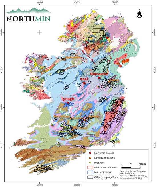
Exhibit 1. Overview map showing the location of the two offered PLAs relative to the Tynagh Project in Ireland.
To view an enhanced version of this graphic, please visit:
https://images.newsfilecorp.com/files/10660/317508_78124c8044b0a874_001full.jpg
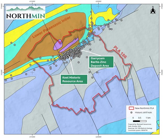
Exhibit 2. Keel PLA 186 on Geological Survey of Ireland bedrock geology map showing historic drillholes and historic resource areas.
To view an enhanced version of this graphic, please visit:
https://images.newsfilecorp.com/files/10660/317508_78124c8044b0a874_002full.jpg
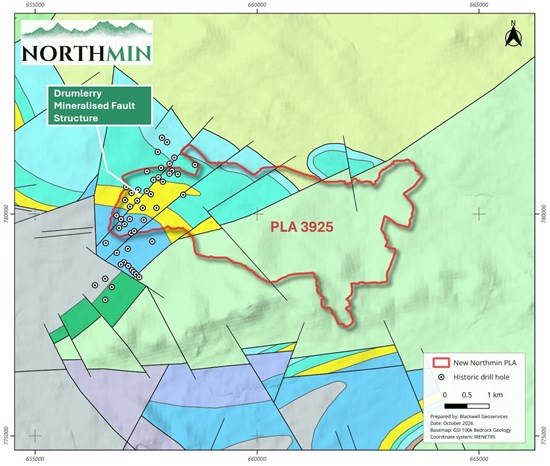
Exhibit 3. Oldcastle PLA 3925 on Geological Survey of Ireland bedrock geology map showing historic drillholes and the location of the Drumlerry mineralized structure.
To view an enhanced version of this graphic, please visit:
https://images.newsfilecorp.com/files/10660/317508_78124c8044b0a874_003full.jpg
Further Information
The Keel Project - A Well-Documented, Historically Significant Irish Zinc System
The carbonate-hosted Keel deposit lies along the Keel Fault System, on the southern margin of the Keel Lower Paleozoic Inlier in County Longford, 68 km northeast of the Tynagh Project in central Ireland. Mineralization is structurally controlled and hosted within multiple steeply dipping faults that strike east-northeast. The mineralization occurs as replacement of carbonate in a series of lenses and breccias lying along the fault structures and, unlike at Tynagh, the host rocks are mainly the Lower Carboniferous mixed units below the Waulsortian reef, including a lower and upper quartzitic sandstone separated by a quartz-pebble conglomerate and overlying lower mixed beds, bioclastic dolomite and upper mixed bed. Sphalerite is the main sulphide and occurs as coarsely crystalline cavity-fill and as fine disseminations. Galena is subordinate to sphalerite but local enrichments occur particularly in the eastern part of the deposit while argentiferous tetrahedrite occurs within sphalerite and galena as minor inclusions. In a study of geochemical analysis of 248 geological samples of Irish base metal style mineralization, the highest gallium concentration was contained within a sample of semi-massive sphalerite from the Keel deposit. The same study found that other Keel samples also report relatively high gallium concentrations. Further work will be required to appraise the Keel mineralization for critical metals such as gallium and germanium.
The Keel deposit was originally discovered and developed by Rio Tinto Finance and Exploration ("Riofinex") in the 1960s and their work included shaft sinking and exploratory underground development however the project never went to production as it did not meet the size criteria for the company.
The Garrycam Deposit, located <1km east from the Keel shaft, had historic non-compliant estimates but the reliability of these estimates from the 1970's cannot be assured and the deposit at the time was considered subeconomic. The stratiform barite-sphalerite body is hosted by the Waulsortian Reef Limestone with massive barite confined to the base of reef but it has not been drilled as extensively as the Keel zinc-silver-lead deposit. Barytes is on the list of EU critical raw minerals and Northmin is targeting barytes recovery from the Tynagh Silver Project.
Riofinex, along with various JV partners, held the project until 1999, and they and subsequent operators drilled more than 280 holes across the wider Keel and Garrycam area, resulting in several historic non-compliant resource estimates however the relevance and reliability of the older historic estimates is uncertain and only the American Smelting and Refining Company ('Asarco' in JV with Riofinex) historic mineral resource estimate (MRE) is backed up by a source document outlining the methodology. In a 1971 licence renewal report, Asarco included calculations as follows:
1971 Asarco MRE:
- Indicated Resource: 2,559,566 short tons at 6.96% Zn and 1.25% Pb
- Inferred Resource: 2,433,080 short tons at 6.74% Zn and 1.22% Pb
- Total Indicated + Inferred: 4,972,646, short tons at 6.85% Zn and 1.24% Pb (Ag estimated at 0.9 oz/ton and Cd at .11% for the total resource)
The historic estimate is based on historic drill intersections and the results of the Rio Tinto underground exploration program in the Keel Shaft Area. Blocks were calculated for 'Fault vein orebodies' in zones C, D, G, H, J and K. A specific volume of 12 cubic ft per short ton was used along with a minimum mining width of 6 feet. Metallurgical analyses indicated that the Keel mineralization was readily amenable to flotation with excellent concentrate grades for zinc. A report containing sections and maps showing all drill holes and the block model used in the calculations is referenced in the section below 'References for Project Information and Historical Exploration' (1971 Asarco MRE).
* The QP has not done sufficient work to classify the historical estimates as current mineral resources or mineral reserves and considers the reported mineralization historical in nature. Additional modern drilling and data verification would be required to confirm these historical results. The QP refers the reader to the QP section and Cautionary Note below.
Modern Non-Compliant Resource Estimates Demonstrate Scale and Continuity
Recent work by Diversified Assets Holdings who held the licence from September 2014 to November 2025, and its then joint-venture partner ASX-listed Longford Resources (previously Ram Resources), resulted in two JORC-compliant Inferred Mineral Resource Estimates. The updated 2020 MRE was published following the drilling of 12 verification holes at Keel in 2017, and extrapolation of silver values was based on consistent Ag:Zn ratios in assays from the new drill holes. The 2020 historic MRE is based on 83 diamond drill holes for a total of 15,968m, the majority of which are angled to the northwest at -60 degrees with some vertical holes and hole spacings of approximately 50m.
2017 CSA Global Inferred MRE: 6.9 Mt at 5.6% Zn, 0.8% Pb (no silver estimate)
2020 Payne Inferred MRE: 11.2 Mt at 4.5% Zn, 17 g/t Ag, 0.6% Pb (at 3% Zn cut-off)
High-grade intercepts reported from 2017 drilling by Longford Resources include:
83m at 4.10 Pb+Zn% and 29 g/t Ag from 134m (KD_2017_02),
including 15m at 7.9 Pb+Zn% and 31 g/t Ag from 165m
6.8 m at 11.7 Pb+Zn% and 40.7 g/t Ag from 141.2m (KD_2017_005)
3 m at 9.4 Pb+Zn% and 24.1 g/t Ag from 191m (KD_2017_005)
4.5m at 18.27 Pb+Zn% and 58.53 g/t Ag from 145.5m (KD_2017_012)
4m at 12.3 Pb+Zn% and 9.2 g/t Ag from 172m (KD_2017_012)
These estimates demonstrate a substantial mineralized system with continuity along multiple fault zones. The report titled Mineral Resource Estimate for the Keel Zinc Lead Silver Deposit, Republic of Ireland, dated July 2020 and compiled by Payne Geological Services Pty Ltd, and all associated digital data for the 2020 JORC mineral resource estimate has been retrieved by Northmin from the GSRO during the competition process. ASX stock exchange announcements for Longford Resources Ltd list the drilling intersections and other exploration results from the Keel Project between June and December 2017.
* The QP has not done sufficient work to classify the historical estimates as current mineral resources or mineral reserves and considers the reported mineralization historical in nature. Additional modern drilling and data verification would be required to confirm these historical results. The QP refers the reader to the QP section and Cautionary Note below.
Exploration Upside and Additional Targets
Previous soil geochemistry, ionic leach sampling, gravity surveys, and Tellus airborne geophysics highlight several untested or partially tested targets, including:
Coincident gravity and geochemical anomalies up to 1.5 km west of the historic resource footprint
Structural targets (T1-T4) identified along strike based on a gravity survey by the previous operator.
Copper soil anomalies to the southwest coincident with southwest-trending structures.
NW-trending breaks that may influence mineralization controls.
These datasets provide a strong foundation for systematic follow-up exploration.
Land Use and Environmental Setting
PLA 186 contains no Special Areas of Conservation (SACs), Special Protection Areas (SPAs), or proposed Natural Heritage Areas (pNHAs). Land use consists primarily of agricultural grazing land and commercial forestry, with low housing density and good road access. No environmental constraints have been identified that would normally impede exploration activities. The historic shaft has been capped.
Northmin's Initial Work Program
The company's exploration commitment for the first two years of the licence is modest and will comprise the drilling of at least two diamond drill holes to verify the mineralization and allow upgrading test work. Upon the final grant of PLA 186, Northmin will commence:
Full validation and reconstruction of the historic drillhole database
Structural reinterpretation and updated 3D geological modelling
Stakeholder engagement and work permitting
Locate, if possible, recent core and scan it using XRF scanners to determine ore-sorting amenability
Infill and verification drilling to improve confidence in higher-grade zones with at least two holes in the first year.
These activities will support the workstreams required to advance the potential hub and spoke strategy being considered by the company.
Strategic Importance to Northmin
PLA 186 is located 68 km from Northmin's Tynagh project, providing potential future synergies within a regional exploration and development portfolio. The Keel licence adds a second advanced-stage zinc-lead-silver asset in Ireland, complementing Northmin's existing operations and strengthening its position in one of Europe's premier zinc districts. The exploration work at Keel will build upon the extensive drill hole database to identify tonnage that can be considered as potential future feed to other operations on brownfield sites.
Further Information - The Oldcastle Project
Overview
The Oldcastle Prospect (PLA 3925) is a shallow Zn-Pb (+/-barite) occurrence hosted in micrite units along the Drumlerry Fault in County Meath. The mineralized zone lies between 50-150 m depth and extends for up to 2 km along strike. Historic drilling was mostly vertical and wide-spaced and has intersected multiple zones of fracture-fill and breccia-style mineralization. Northmin considers that the historical drilling may warrant further investigation of potential higher-grade, steep-dipping structures that may not have been tested by wide-spaced vertical drilling to date. Historically, there have been no silver assays reported for the Oldcastle prospect.
The licence is low-commitment incentive ground (minimum expenditure of €5,000 over two years) and is early stage.
* The QP has not done sufficient work to classify the historical estimates as current mineral resources or mineral reserves and considers the reported mineralization historical in nature. The QP refers the reader to the QP section and Cautionary Note below.
Geology, Mineralogy and Potential
Mineralization is hosted mainly in the top micrite and Lower Pale Beds above the basal sandstone-Paleozoic unconformity. Logs indicate that both grade and thickness increase closer to the steep-dipping Drumlerry Fault, with mineralization intensity strongly controlled by distance from the structure. Historic documents indicate that mineralization appears to be in the first clean carbonate (top micrite) unit and certain beds allow mineralization to bleed away from the fault implying that mineralization is likely much stronger on feeder structures that have yet to be drilled. One document mentions tetrahedrite which suggests that higher-temperature hydrothermal fluids may have circulated along structures similar to other Irish-type deposits.
Historical drilling of vertical holes go back to 1976 with some more recent drilling in 2007 and 2008 carried out by Connemara Mining Plc. Assay results include:
Drillhole 81-LS-57: 3.81 m @ 4.8% Pb/Zn + 8.76% BaSO4, including 1.07 m @ 2.65% Pb, 9% Zn.
Drillhole 78-LS-37: Multiple breccia-hosted intervals including 0.91 m @ 6% Pb/Zn and several 1-1.5 m zones grading 2.5-4% Pb/Zn.
Drillhole 81-LS-59: 2.5 m @ 10.46% Zn & 1.85% Pb at the fault plane.
Drillhole C-3925-005: 4.7 m @ 3.38% Zn, 0.59% Pb drilled by Connemara Mining in February 2008.
Work Plans
PLA 3925 offers a low-cost opportunity to add near-surface tonnes to the company's resource base to support a potential hub and spoke strategy. Northmin has compiled the available drill data and other relevant exploration data including more recent resistivity data acquired by Connemara Mining and the company will interrogate this to identify priority drill targets to test the mineralized structure with angled drilling at shallow depth. The resistivity data indicates possible NW-trending cross-structures that may localise higher-grade shoots along the northeast striking Drumlerry Fault or may offset mineralized structures.
A proposed staged and inexpensive work plan will likely consist of:
Further Data Compilation and incorporation of historic geophysics and new Tellus Mag and EM datasets and digital surface models into GIS.
Ground Geophysics such as ground magnetic or IP surveys to better define the fault plane.
Soil Geochemistry with tight-spaced soil lines across the fault to identify zones of strongest anomalism.
Targeted angled drilling to test the fault plane within the top micrite-addressing the major gap in historic vertical drilling. These holes will aim to reveal true grade, thickness, and structural controls in potential feeder zones.
Qualified Person
Technical information in this news release has been prepared by and approved by Aiden Lavelle EurGeol, P.Geo, General Manager Ireland for Northmin and a qualified person (a "QP") as defined under National Instrument 43-101. Standards of Disclosure for Mineral Projects ("NI 43-101").
The QP has not done sufficient work to classify the historical estimates as current mineral resources or mineral reserves and considers the reported mineralization historical in nature. These results have not been fully verified by the QP as the original core, assay certificates, and quality control data are partially unavailable to the Company. While the Company believes these historic results are highly relevant to future exploration targeting in the area, it is not treating the historical estimate as current mineral resources or mineral reserves and believes that they should not be relied upon as a current representation of mineralization. Additional modern drilling and data verification would be required to confirm these historical results.
References for Project Information and Historical Exploration
Keel
1971 Asarco MRE: Report of exploration completed by the American Smelting and Refining Company on the Rio Tinto Finance and Exploration Ltd. Prospecting Licenses Nos. 183 to 186 inclusive, 580 to 582 inclusive and 664, 666 and 667 between May 1, 1970 and October 19, 1971. The report author is Jeff Sample and the report is dated December 7, 1971.
2017 CSA Global MRE Report: Mineral Resource Estimate Keel Deposit, Republic of Ireland. Author CSA Global. Report Nº R155.2017 dated 22 March 2017. Authors Steve Rose and Bill Guy.
2020 Payne MRE Report: Mineral Resource Estimate for the Keel Zinc Lead Silver Deposit, Republic of Ireland. For Diversified Asset Holdings Pty Ltd. Compiled by Payne Geological Services Pty Ltd, July 2020.
ECE Characterisation of Irish Mineral Deposits, Dave Blaney P.Geo., Eamonn Grennan P.Geo., Shane Lavery P.Geo., and Dr. Dermot Smyth FGS. Available at link below: https://storymaps.arcgis.com/stories/03b8c596bc52458cbc9a6881bab9f5db.
Previous public announcements by ASX-listed Longford Resources, including those with drill results can be located online e.g. Announcement dated 18 August 2017 Shallow High Grade Zinc and Silver Mineralisation Continues at Keel Zinc Project.
Oldcastle
Brand, S.F. and Emo G.T., A note on Zn-Pb-Ba mineralization near Oldcastle Co. Meath in Geology and Genesis of Mineral Deposits in Ireland, Irish Association of Economic Geology.
R22/08 Lough Sheelin Renewal Report for Connemara Mining Company PL 3925, County Meath. Graham Reid, December 2008.
R38/10 Lough Sheelin PL 3925 Renewal Report for Connemara Mining Company County Cavan Graham Reid, December 2010.
About Northmin Corporation
Northmin Corp. (TSXV: NMB) is an exploration and development company advancing the 100%-owned Surface Silver Project at Tynagh and the Tynagh Copper-Zinc-Silver brownfield exploration project near Loughrea in County Galway, Ireland. The Tailings Ponds supporting the Surface Silver Project have a NI 43-101 compliant resource consisting of 2.69Mt Inferred at 21.6% BaO, 49 g/t Ag, 3.56% Zn, 2.68% Pb and 0.23% Cu in the West Pond, 1.26Mt Indicated at 13.2% BaO, 34 g/t Ag, 3.63% Zn, 2.16% Pb and 0.15% Cu in the East Pond (bottom) and 2.7Mt Indicated at 9.5% BaO, 13 g/t Ag, 1.02% Zn and 0.65% Pb in the East Pond (top). The tailings ponds are accessible and there has been little to no rehabilitation of the site since mine closure in 1985. The Company is also assessing the waste stockpile on the site and recently announced high-grade copper drill results from below the historic Zn-Pb-Ag mine at Tynagh including 6.4m grading 4.92% Cu, 0.98% Sb & 62.04 g/t Ag from 149.0m in hole 3615-26-07 and 2.45m grading 4.03% Cu, 24.87% Zn+Pb, 0.47% Sb and 313.82 g/t Ag from 106.75m in hole 3615-26-08, including 0.75m grading 933 g/t Ag and 12.75% Cu.
ON BEHALF OF THE BOARD OF DIRECTORS
Julian Vickers
Chief Executive Officer
E: investors@northmincorp.com | T: 647.202.3904
E: a.lavelle@northmincorp.com | T: +353-86-392-1523
Neither TSX Venture Exchange nor its Regulation Services Provider (as that term is defined in the policies of the TSX Venture Exchange) accepts responsibility for the adequacy or accuracy of this release.
Cautionary Note Regarding Forward-Looking Information
Mineral Resources that are not Mineral Reserves do not have demonstrated economic viability. The estimate of Mineral Resources may be materially affected by environmental, permitting, legal, title, taxation, socio-political, marketing or other relevant issues. The quantity and grade of reported Inferred Mineral Resources are uncertain in nature and there has been insufficient exploration to define these Inferred Mineral Resources as Indicated or Measured Mineral Resources, as defined under NI 43-101. It is uncertain if further exploration will result in upgrading them to the Indicated or Measured category.
References to exploration results, mineralization, mineral resources or exploration successes on adjacent or nearby properties are provided for geological context only and are not necessarily indicative of the mineralization, exploration potential or results that may be achieved on the Keel or Oldcastle project.
Certain information set out in this news release constitutes forward-looking information. Forward looking statements are often, but not always, identified by the use of words such as "seek", "anticipate", "plan", "continue", "estimate", "expect", "may", "will", "intend", "could", "might", "should", "believe" and similar expressions. Forward-looking information in this news release includes, without limitation, statements regarding: the final grant of PLA 186 and PLA 3925; the prospectivity of the Keel, Garrycam and Oldcastle projects; the interpretation, relevance and significance of historical exploration data, historical drill results and historical estimates; the potential for zinc, lead, silver, gallium, germanium and other mineralization on the licence areas; the potential continuity, extent and grade of mineralization; the Company's planned data compilation, verification, geological modelling, stakeholder engagement, geophysical, geochemical and drilling programs; the verification and validation of historical exploration results and estimates; the potential for the delineation of current mineral resources; the potential application of ore-sorting, pre-concentration or other processing technologies; the potential hub-and-spoke development strategy involving the Company's Irish projects; and the Company's future plans, objectives and strategy for the Keel, Garrycam, Oldcastle and Tynagh projects. Forward-looking statements are based upon the opinions and expectations of management of the Company as at the effective date of such statements and, in certain cases, information provided or disseminated by third parties. Forward-looking information is based on a number of assumptions, including, among others, assumptions regarding the accuracy of geological interpretations, the continuity of mineralization, the reliability of historical data, the relevance and reliability of historical exploration data, the continuity and prospectivity of geological structures and mineralization, the availability of financing, personnel and equipment, the receipt and maintenance of required permits, licences and approvals, and general business, economic, market and regulatory conditions. Although the Company believes that the expectations reflected in forward-looking statements are based upon reasonable assumptions, and that information obtained from third party sources is reliable, they can give no assurance that those expectations will prove to have been correct. Readers are cautioned not to place undue reliance on forward-looking statements.
These forward-looking statements are subject to a number of risks and uncertainties. Such risks and uncertainties include, without limitation: exploration and development risks; accuracy and completeness of historical exploration data and historical estimates, the accuracy of geological interpretations, the continuity of mineralization, the prospectivity of identified targets; uncertainties relating to permitting and regulatory approvals; environmental and community relations risks; delays or changes in planned work programs; financing and market risks; commodity price fluctuations; and general economic, business and political conditions. Actual results may differ materially from results contemplated by the forward-looking statements. Accordingly, the actual events may differ materially from those projected in the forward-looking statements. Such risks include uncertainties relating to exploration activities. When relying on forward-looking statements to make decisions, investors and others should carefully consider the foregoing factors and other uncertainties and should not place undue reliance on such forward-looking statements. The Company does not undertake to update any forward-looking statements, except as may be required by applicable securities laws.

To view the source version of this press release, please visit https://www.newsfilecorp.com/release/317508
