Vancouver, British Columbia--(Newsfile Corp. - October 5, 2026) - Americas Uranium Corp. (CSE: NUCA) (OTCQB: ASRFF) (FSE: WA7) (the "Company" or "Americas Uranium") is pleased to announce that its consultant, Axiom Exploration Group Ltd., has completed the integration of TDEM, ground gravity and magnetic survey results at the Company's Ford Lake Uranium Project (the "Ford Lake Property"), located on the south-eastern edge of the Athabasca Basin, Saskatchewan. This work represents the next step in the Company's systematic exploration strategy following completion of the 2025 ground gravity survey and the 2026 property-scale structural lineament and favorability analysis.
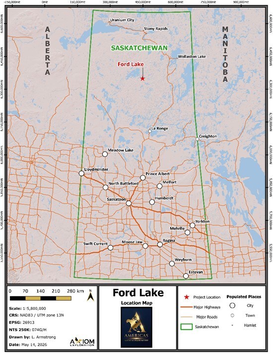
Figure 1: Location of the Ford Lake Property
To view an enhanced version of this graphic, please visit:
https://images.newsfilecorp.com/files/12293/317532_4cdf28e574e20beb_001full.jpg
Exploration Program Progress
The Company's exploration program at Ford Lake continues to systematically advance and refine high-priority uranium targets through a staged, multidisciplinary data-integration approach.
The 2025 ground gravity survey identified a series of discrete density variations and gravity-low features considered prospective for further investigation. Building on these results, the Company completed a detailed structural interpretation in 2026 integrating regional geology, geophysics and remote-sensing datasets to define prospective structural corridors and identify areas of enhanced structural complexity and favorability.
The resulting structural model highlights dominant northeast-southwest structural trends, complemented by secondary northwest-southeast and east-northeast-west-southwest trends. These intersecting structural orientations provide an important framework for evaluating potential pathways and structural settings potentially favorable for uranium mineralization and have been incorporated into the Company's ongoing target-ranking process.
To further refine these targets and delineate areas of enhanced uranium prospectivity, Axiom Exploration Group Ltd. has completed a property-wide integration of the 2023 time-domain electromagnetic ("TDEM") survey completed by Geotech Ltd., the 2025 ground gravity survey completed by TUZO Geosurveys, and publicly available regional magnetic data.
A layered-earth inversion volume of the TDEM dataset was used to generate apparent conductivity-depth sections along each flight line. Independently, unconstrained inversions of the ground gravity and regional magnetic datasets were used to generate discrete three-dimensional density and magnetic susceptibility anomaly bodies.
These independently derived geophysical products were then directly compared and spatially integrated with the structural interpretation to identify areas where multiple exploration indicators converge. This integrated approach has enhanced the Company's ability to prioritize discrete target areas for further investigation.
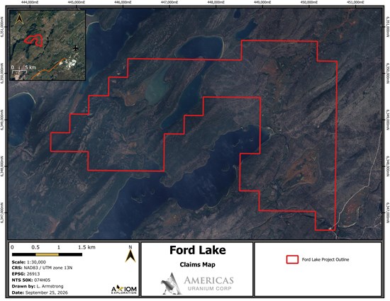
Figure 2: Ford Lake Property Mineral Disposition
To view an enhanced version of this graphic, please visit:
https://images.newsfilecorp.com/files/12293/317532_4cdf28e574e20beb_002full.jpg
Results
The integrated interpretation has identified a compelling combination of structural and geophysical features that has further refined the Company's exploration targeting at Ford Lake.
Rather than relying on any single geophysical response, the Company's targeting methodology evaluates the spatial coincidence of multiple independent exploration indicators. Areas where favorable structural architecture coincides with conductive responses, gravity anomalies and supporting geological evidence are considered by the Company as higher-priority areas for follow-up exploration.
Based on the conductivity inversion results from the 2023 TDEM survey, the interpreted base of the slightly less resistive sandstone sequence occurs at approximately 260 meters below terrain (Figure 5). The conductivity inversion also indicates an offset to the unconformity coincident with the EM conductor. This offset may indicate reactivation of a basement fault that displaced the sandstone-basement contact, and fracturing along this fault could potentially indicate channel uranium-bearing hydrothermal fluids toward the unconformity, focusing the fluid flow. Under this thesis, the fault-unconformity intersection could potentially provide a chemical trap where oxidized, uranium-bearing fluids encounter reducing rocks or fluids, causing dissolved uranium to precipitate as uranium minerals.
Importantly, the integrated interpretation has outlined a series of discrete gravity lows developed along the regional northeast-southwest geophysical corridors characteristic of the Athabasca Basin. Several of these gravity features are spatially associated with zones of elevated apparent conductivity identified by the TDEM survey and occur proximal to the interpreted southern limb of a fold defined from regional magnetic data (Figures 3 and 4).
Although gravity lows are not direct indicators of uranium mineralization, they can potentially reflect geological conditions associated with alteration, structural disruption or lithological contrasts. Their coincidence with conductive trends and favorable structural architecture therefore provides a technically compelling basis for deeper investigation.
Of particular interest is a gravity-low feature located slightly southeast of a northwest-dipping conductor. The spatial relationship between these features may indicate structural disruption within the interpreted footwall of the conductor-an exploration setting considered favorable for further evaluation of potential uranium mineralization.
The combination of conductive responses, discrete gravity lows and favorable structural architecture provides a strong technical rationale for continued advancement and prioritization of the Ford Lake target area.
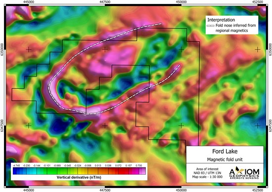
Figure 3: Magnetic unit interpretation
To view an enhanced version of this graphic, please visit:
https://images.newsfilecorp.com/files/12293/317532_4cdf28e574e20beb_003full.jpg
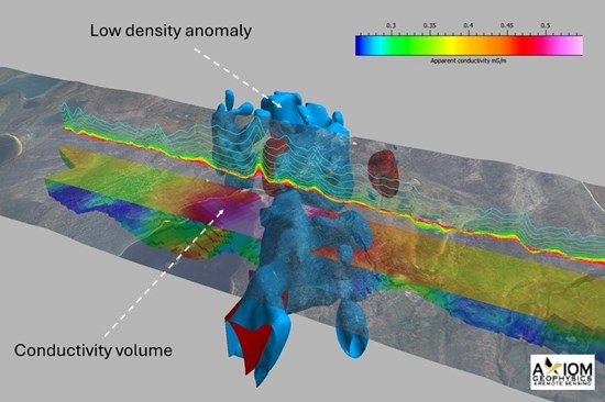
Figure 4: Section through layered earth conductivity volume (mS/m) with isoshells extracted from 3D gravity and magnetic inversion volumes (blue = gravity low, red = magnetic high), shown below property satellite imagery.
To view an enhanced version of this graphic, please visit:
https://images.newsfilecorp.com/files/12293/317532_4cdf28e574e20beb_004full.jpg
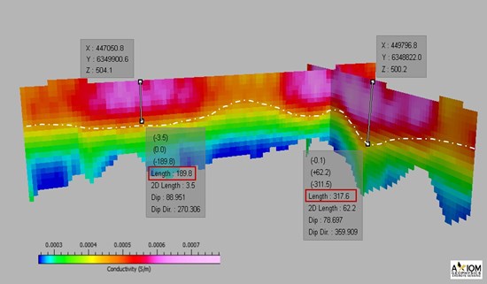
Figure 5: Approximate depth to unconformity (200m - 310m below surface) inferred from layered earth conductivity inversion of VTEM data.
To view an enhanced version of this graphic, please visit:
https://images.newsfilecorp.com/files/12293/317532_4cdf28e574e20beb_005full.jpg
Exploration Targeting and Next Steps
Axiom Exploration, together with Technical Advisor Denis Goulet, P.Geo., is finalizing a prioritized drill target list that integrates the combined EM-gravity-magnetic results outlined above with additional modeling and the property-scale structural lineament and favorability model previously reported by the Company, while also integrating recently acquired data from an MT survey completed in 2025 by Expert Geophysics for Mustang Energy. Once the integration and delineated drill/target areas are complete, the Company intends to systematically prioritize upcoming exploration activities, optimizing the design of future geological, geochemical, geophysical programs and designing a drill program, to test the delineated target conductor picks.
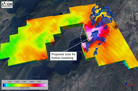
Figure 6: Prospective areas for further data modeling and delineation prior to drill target finalization.
To view an enhanced version of this graphic, please visit:
https://images.newsfilecorp.com/files/12293/317532_4cdf28e574e20beb_006full.jpg
Management Commentary
Nick Luksha, CEO of Americas Uranium Corp., commented:
"We are excited by the continued advancement of Ford Lake and the strength of the targets emerging from our integrated exploration work," said Nicholas Luksha, CEO of Americas Uranium Corp. "The convergence of favorable structural architecture, conductive responses and discrete gravity lows provides a compelling technical foundation for the next phase of exploration. Ford Lake continues to demonstrate the potential we saw when assembling our portfolio, and we look forward to advancing these targets toward the next stage of evaluation."
Ford Lake Project
The Ford Lake Property lies within the south-eastern edge of the uranium-producing Athabasca Basin. It is located approximately 15 km northwest of the currently operating Key Lake uranium mill and approximately 580 km north-northeast of Saskatoon, Saskatchewan. The property lies near the transition between the Wollaston and Mudjatik domains, which host several significant unconformity- and basement-hosted uranium deposits.
The Company advises that, notwithstanding their proximity and location, discoveries of minerals on or near historic mines such as the Key Lake Mine site or deposits within the Wollaston and Mudjatik domains, and any promising results thereof, are not necessarily indicative of mineralization on the Ford Lake Property, the Company's ability to commercially exploit the Ford Lake Property, or the presence of any commercially exploitable deposit therefrom.
Qualifying Person Statement
The scientific and technical information in this news release has been reviewed and approved by Denis Goulet, P.Geo., Technical Advisor for Americas Uranium Corp., and a registered member of the Professional Engineers and Geoscientists of Saskatchewan. Mr. Goulet is a Qualified Person as defined by National Instrument 43-101.
For a discussion of the Company's QA/QC and data verification processes and procedures, please see its most recently-filed technical report, a copy of which may be obtained under the Company's profile at www.sedarplus.ca.
Cautionary Statement / Technical Disclaimer
Geophysical, structural and remote-sensing interpretations are predictive in nature and do not constitute direct evidence of uranium mineralization. Interpreted anomalies, conductors, structures and target areas require validation through appropriate field investigations and, where warranted, drilling. There can be no assurance that exploration targets will result in the discovery of mineralization or an economically viable mineral deposit.
About Americas Uranium Corp.
Americas Uranium Corp. is a Canadian mineral exploration company focused on the discovery and development of high-potential uranium assets. The Company holds a portfolio of 4,700 hectares of strategically located properties in Saskatchewan's Athabasca Basin, one of the world's premier uranium districts. Americas Uranium is advancing early-stage exploration through modern techniques and a disciplined, data-driven approach. The Company is committed to building long-term value through responsible exploration and a focus on high-impact targets in underexplored areas.
For Further Information
Americas Uranium Corp.
www.americasuraniumcorp.com
info@americasuraniumcorp.com
604-838-0184
Cautionary Statement Regarding Forward-Looking Information
This news release contains certain "forward-looking information" and "forward-looking statements" within the meaning of applicable Canadian securities legislation (collectively, "forward-looking information"). Forward-looking information is generally, but not always, identified by words such as "anticipates", "believes", "expects", "intends", "plans", "projects", "estimates", "may", "could", "would", "will", "should", "potential", "proposed", "target", "continue", "advance" and similar expressions, or statements that certain events, conditions or results will, may or could occur, be achieved or be realized.
Forward-looking information in this news release includes, but is not limited to, statements regarding: the interpretation, significance and prospective nature of geophysical, structural, geological and remote-sensing data and anomalies at the Ford Lake Property; the potential for conductors, gravity lows, structural corridors, fault-unconformity intersections and other interpreted features to be associated with uranium mineralization; the finalization, ranking and prioritization of exploration and drill targets; the integration of additional modelling and third-party survey data; the design, timing, scope and execution of future geological, geochemical, geophysical and drilling programs; the advancement of the Ford Lake Property and the Company's exploration strategy; and the potential discovery, delineation or development of uranium mineralization or an economically viable mineral deposit.
Forward-looking information is based on management's current expectations, estimates, projections and assumptions, including assumptions regarding the accuracy, completeness and reliability of historical, public, third-party and newly acquired data; the validity of geophysical inversions, interpretations and exploration models; the availability of financing, personnel, equipment, contractors and infrastructure on acceptable terms; the timely receipt and maintenance of required permits, approvals and access rights; the ability to conduct exploration activities safely and in accordance with applicable laws; the absence of material adverse changes in commodity prices, market conditions and the regulatory environment; and the Company's ability to carry out its proposed exploration programs as currently contemplated.
Forward-looking information is subject to known and unknown risks, uncertainties and other factors that may cause actual results, performance or achievements to differ materially from those expressed or implied, including risks inherent in mineral exploration and development; the speculative nature of early-stage exploration; the possibility that interpreted anomalies, conductors, structures and targets will not be confirmed by fieldwork or drilling or will not result in the discovery of mineralization or an economically viable mineral deposit; uncertainties relating to the accuracy and interpretation of geophysical, geological, remote-sensing and historical data; changes to exploration plans, budgets, timelines and priorities; cost overruns, delays, equipment failures and adverse weather or field conditions; the availability of capital and the terms of any required financing; commodity-price and capital-market volatility; title, access, permitting, environmental, regulatory, Indigenous consultation and community-relations risks; reliance on key personnel, consultants, contractors and third-party data; competition for labour, services and equipment; and the other risks disclosed in the Company's continuous disclosure filings available under its profile on SEDAR+.
There can be no assurance that the Company will finalize or drill any of the targets described in this news release, that any exploration program will be completed as currently proposed, that any interpreted geological or geophysical feature will be validated, or that any exploration activities will result in the discovery, delineation or development of uranium mineralization or an economically viable mineral deposit. The scientific and technical information and exploration concepts described in this news release are preliminary and subject to further verification and interpretation.
Although the Company believes that the assumptions and expectations reflected in the forward-looking information are reasonable as of the date of this news release, no assurance can be given that they will prove to be correct. Readers are cautioned not to place undue reliance on forward-looking information. Forward-looking information is provided as of the date of this news release, and the Company disclaims any intention or obligation to update or revise such information, whether as a result of new information, future events or otherwise, except as required by applicable securities laws.
The Canadian Securities Exchange has not reviewed, approved or disapproved the contents of this news release.
To view the source version of this press release, please visit https://www.newsfilecorp.com/release/317532