VANCOUVER, BC / ACCESS Newswire / December 4, 2025 / Prospect Ridge Resources Corp. (the "Company" or "Prospect Ridge") (CSE:PRR)(OTCQB:PRRSF)(FRA:OED) is pleased to announce visual observations and portable XRF results from the first six holes of a ten hole (~2,000 m) diamond drill program at the Company's 100% owned Camelot copper-gold project in British Columbia's prolific Cariboo Mining District (Figure 1).
Drilling began October 31, with this news release summarizing results from six holes completed from five drill sites along the southwestern 650 m portion of a 1.7 km long geochemical and geophysical trend (Figure 2). Drilling targeted historical copper-in-soil anomalies coincident with chargeability highs and moderate magnetic highs, following an alkalic porphyry exploration model where coincident chargeability and magnetic anomalism could indicate pyrite-chalcopyrite mineralization in association with magnetite-bearing potassic alteration. The target area is covered by till and has never been drill tested (Figure 3).
Drilling Highlights
Results described for 1,065 m drilled in six holes (CAM25-001 to 006) over the first 11 drilling days of the work program.
Semi-quantitative real-time elemental analysis of drill core with a portable X-ray fluorescence spectrometer (pXRF), coupled with visual observations, confirm presence of disseminated pyrite and chalcopyrite over 75 to 120 m of drill core in four of the six holes reported here (CAM25-001, -002, 005, and -006)
Mineralized intervals are associated with overprinting alteration and vein assemblages, particularly holes CAM25-001, 002, and 006. These intervals exhibit multiple episodes of moderate to strong porphyry-style alteration and veining, which includes strong K-feldspar, albite, and epidote alteration.
Hole CAM25-003 showed weak to moderate porphyry-style alteration, dominantly quartz veins with lesser K-feldspar veins, and pyrite with lesser chalcopyrite mineralization; all generally increasing in intensity with depth.
To test as many targets as possible, holes CAM25-001, -002, and -006 were stopped at about 200 m, despite the presence of pyrite and chalcopyrite at the bottom of the holes. Drill core samples from holes CAM25-001 and CAM25-006 has been sent for "rush" assay.
Visual and pXRF results from the first six holes informed a re-evaluation of targets, resulting in modifications to the final four holes (CAM25-007 to CAM25-010) to incorporate real-time improvements in understanding prospective features.
Len Brownlie, Ph.D., CEO of Prospect Ridgenoted "The inaugural Camelot drill program has exceeded our expectations with the discovery of chalcopyrite in four of the first six holes. I would like to thank Equity Exploration Consultants Ltd., and Dorado Drilling for their quick and efficient execution of this drill program. On November 13 and 15, Equity Exploration geologists, members of the Board and our Technical Advisory Committee had the opportunity to observe the first six holes of Camelot drill core and compare it to core from a nearby mine, which has enhanced our ability to identify the complex lithologies of the intrusive rocks present in the Camelot drill core and advanced our understanding of the association between the various intrusive bodies and their geophysical signatures. This knowledge has allowed us to modify the drill plan on the fly, targeting predominantly high chargeability targets (>27mV/V) as we see a greater correlation between moderate-high chargeability and disseminated pyrite and chalcopyrite in the drill core. We anxiously await gold and copper assay results to confirm our hypothesis that Camelot contains a significant alkalic porphyry deposit."
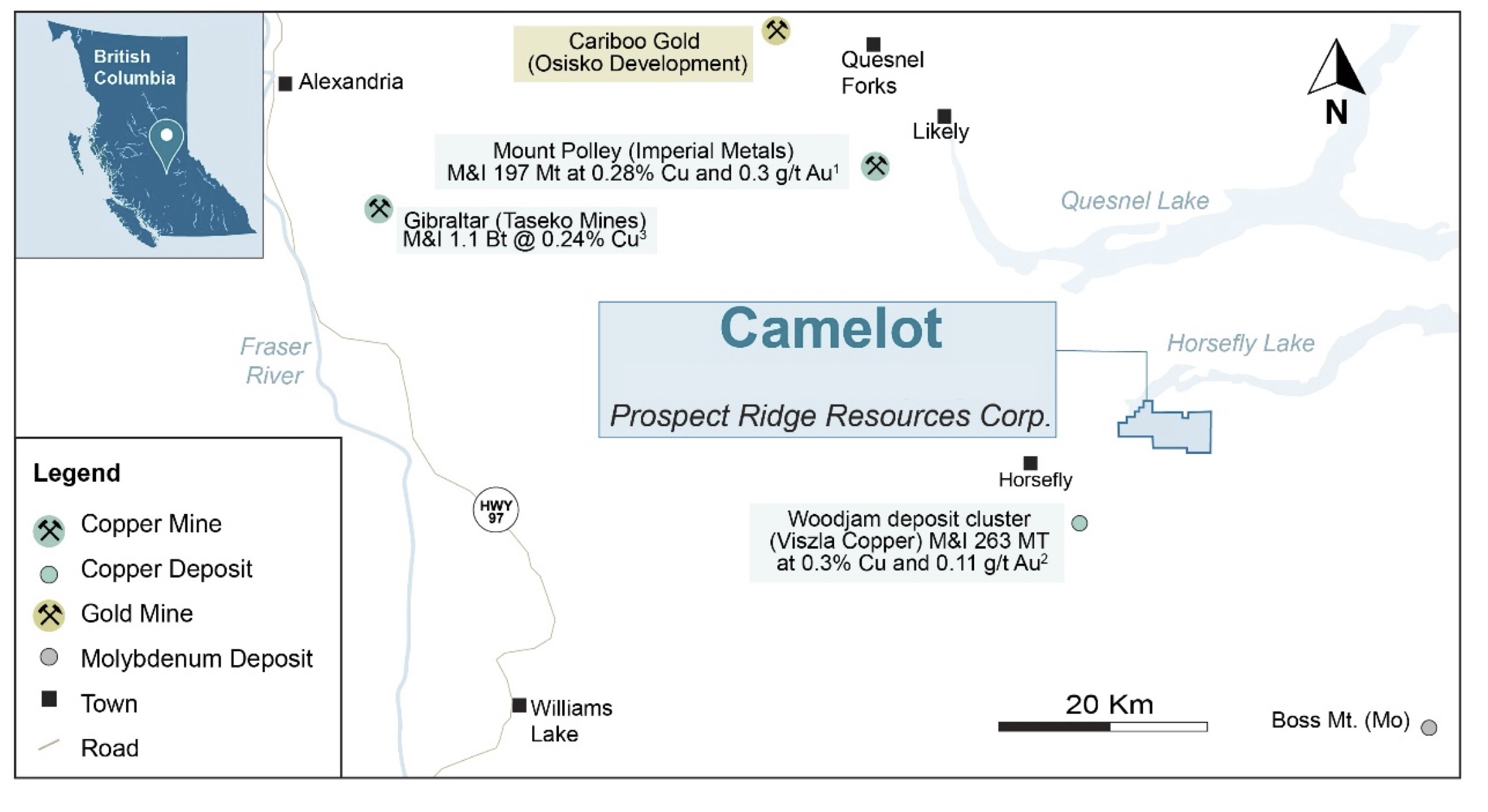
Figure 1: Map showing location of the Camelot property relative to nearby mines and deposits*
*Sources for Figure 1:
1. Mt. Polley: https://www.imperialmetals.com/assets/docs/mp-technical-report-may-20-2016.pdf
2. QR: https://osiskogr.com/en/osisko-gold-royalties-announces-spin-out-of-mining-assets-and-creation-of-a-premier-north-american-gold- development-company/
3. Woodjam: https://www.vizslacopper.com/projects/woodjam-project/overview/
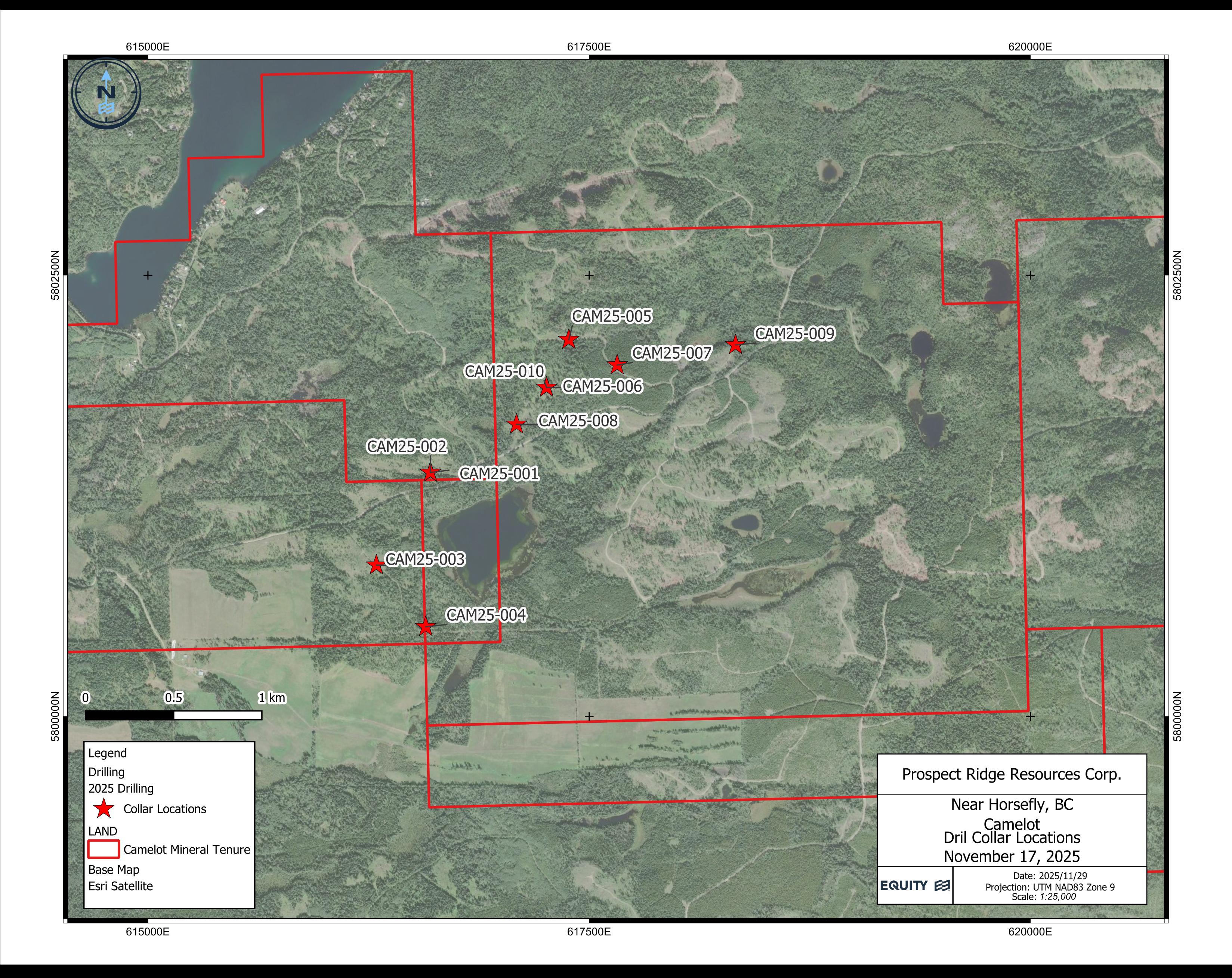
Figure 2: Map showing location of drill hole collars on the Camelot property.
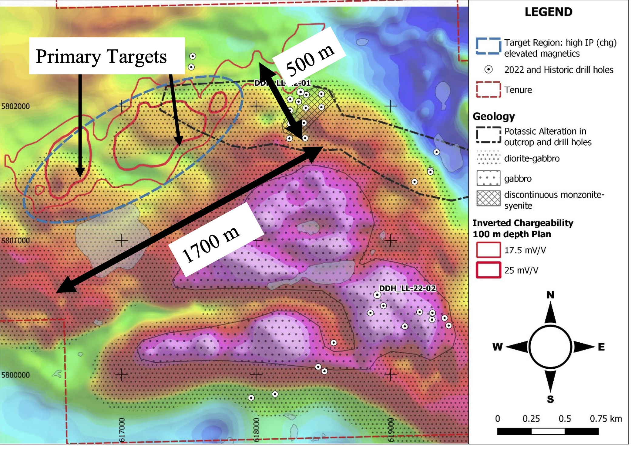
Figure 3: Property geology, soil geochemistry, and IP data compilation over airborne TMI (total magnetic intensity) map (after Baknes, 2023i).
Portable XRF
A portable XRF analyzer has been used to aid in the identification of very fine grained and disseminated chalcopyrite in rocks where strong alteration makes identification difficult. The pXRF provides reliable copper identification, in this case taken as spot samples from a ~0.5 cm2 area of drill core at 1 m intervals.
Despite their reliability, pXRF analyses of drill core are less representative than wet-chemical assays - as they represent such a small quantity of rock - and in this particular case should be regarded as a qualitative screening tool that complements visual core logging.
Portable XRF analyses have detected the presence of copper over core lengths of ~75 to 120 m in four of the six holes described here; the other two (CAM25-003, CAM25-004) were not yet analyzed by pXRF. Copper measurements are shown as histograms in cross-sections for holes CAM25-001, CAM25-002, and CAM25-006 (see Drill Hole Cross-Sections) and demonstrate continuity and variance in copper grades that are consistent with visual logging (see below).
Accurate copper and gold values will be determined by wet geochemical and fire assay methods, respectively. Samples from holes CAM25-001 and CAM25-006 were submitted to the lab on a "rush" basis so that assays are expected in late December. True widths of mineralization are unknown at this time.
Visual Observations in Drill Core
Photos of selected core intervals from holes CAM25-001 and CAM25-006 are shown below in Figures 4 and 5. Drill hole locations are provided in Table 1. These photos illustrate the typical intrusive rock units associated with the presence of pyrite (py) and chalcopyrite (cpy) seen in altered sections of the drill core.
The CAM25-001 and CAM25-002 targets were drilled from the same pad. Both holes tested a coincident chargeability high and an inverted magnetic apophysis-like structure (Figure 6); CAM25-002 focused on the magnetic anomaly. Both holes returned significant intervals of fine-grained disseminated pyrite and lesser chalcopyrite hosted in moderate to strong potassic-altered monzonite and intermediate to mafic volcanic rocks.
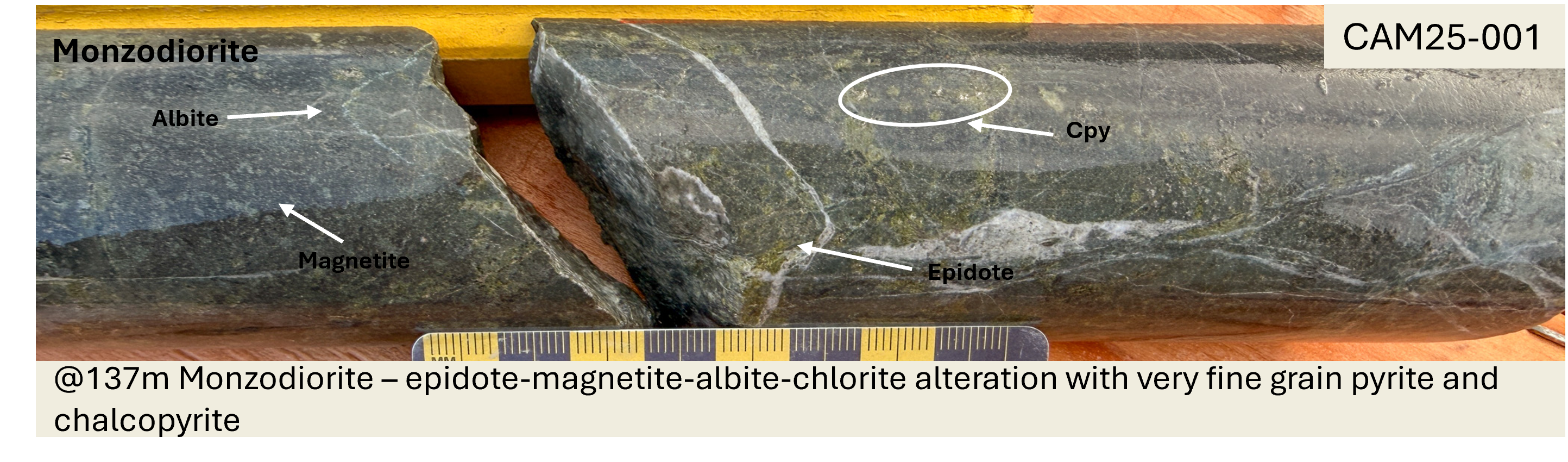
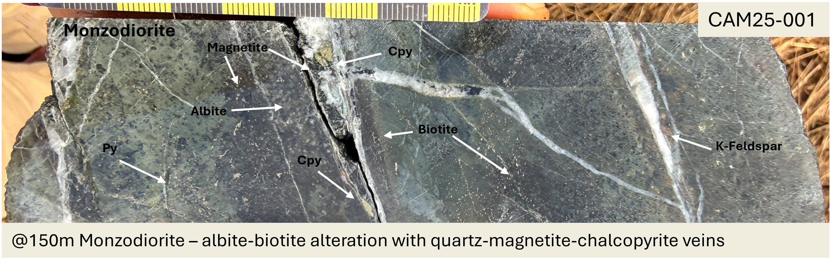
Figure 4: Photos of chalcopyrite mineralization and alteration within drill core from drill hole CAM25-001 at drilled depths of (top) 137 m and (bottom) 150 m from the top of hole.
CAM25-003 and CAM25-004 targeted closely associated moderate chargeability and magnetic features at depth of 90 to 150 m below the surface. CAM25-003 intersected mostly highly magnetic gabbro with weak pyrite mineralization and trace disseminated chalcopyrite. CAM25-004 was quick-logged as the same gabbro with full logging paused until efforts on other targets had been concluded.
CAM25-005 and CAM25-006 tested a large high chargeability anomaly with isolated inverted magnetic pipe like features at depth (Figure 7). Drill hole CAM25-005 intersected mostly weak to moderately pyrite-mineralized diorite with trace to weak disseminated chalcopyrite, and elevated (2-5%) quartz and quartz-carbonate veinlets.
Drill hole CAM25-006 intersected variably K-feldspar altered andesite, diorite, and monzodiorite, hosting minor amounts of fine disseminated pyrite and 1-4% pyrite veinlets, as well as weak to trace very fine grain chalcopyrite from 140 m depth to the end of hole.
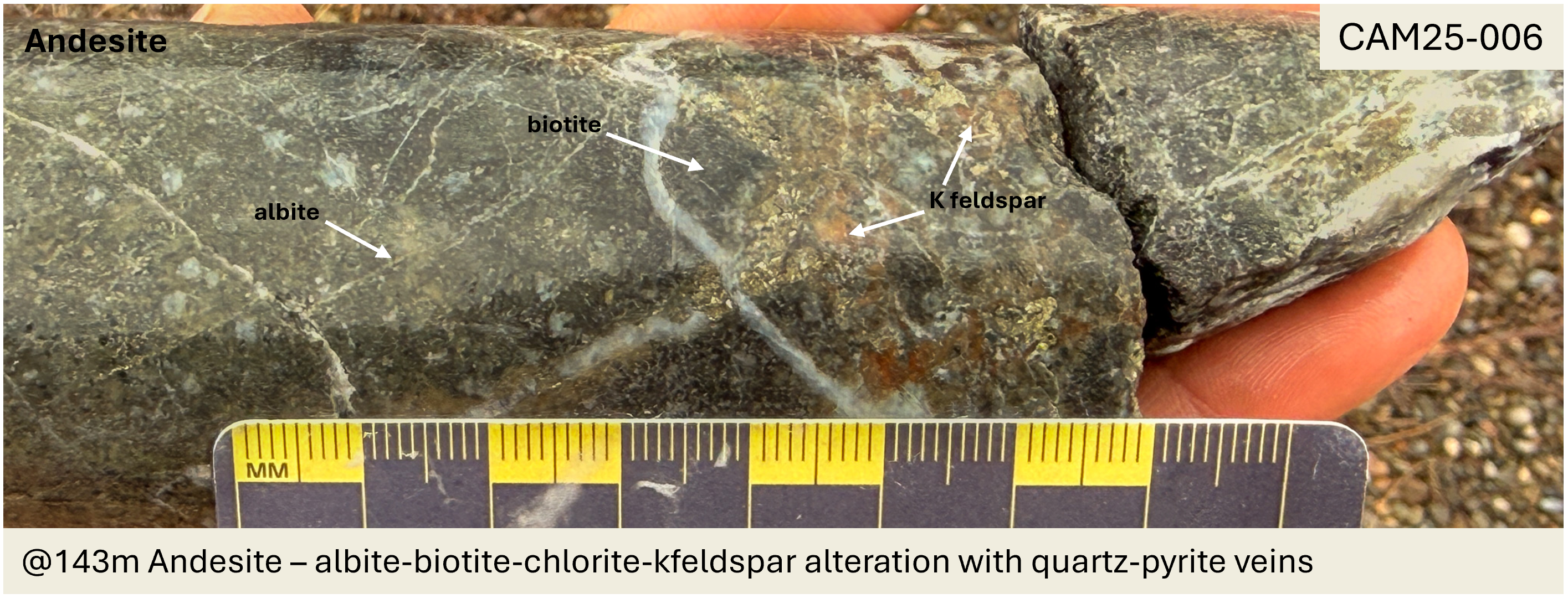
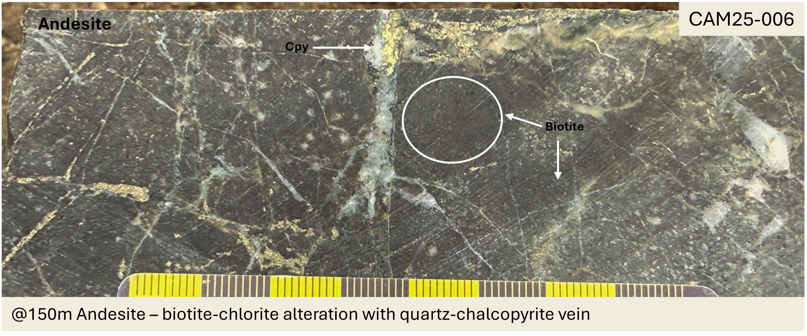
Figure 5: Photos of (top) alteration and (bottom) chalcopyrite mineralization and alteration within drill core from drill hole CAM25-006 at drilled depths of 143 m and 150 m respectively.
Drill Hole Cross-Sections
Cross sections for holes CAM25-001, -002, and -006 are shown in Figures 6 and 7. Readers are cautioned that copper (Cu) values shown in the figures are based on single pXRF measurements every 1-meter length of core. These values should be interpreted as a qualitative indicator of the continuity and variance in copper mineralization but do not provide an accurate quantitative measurement of the copper concentration in the core.
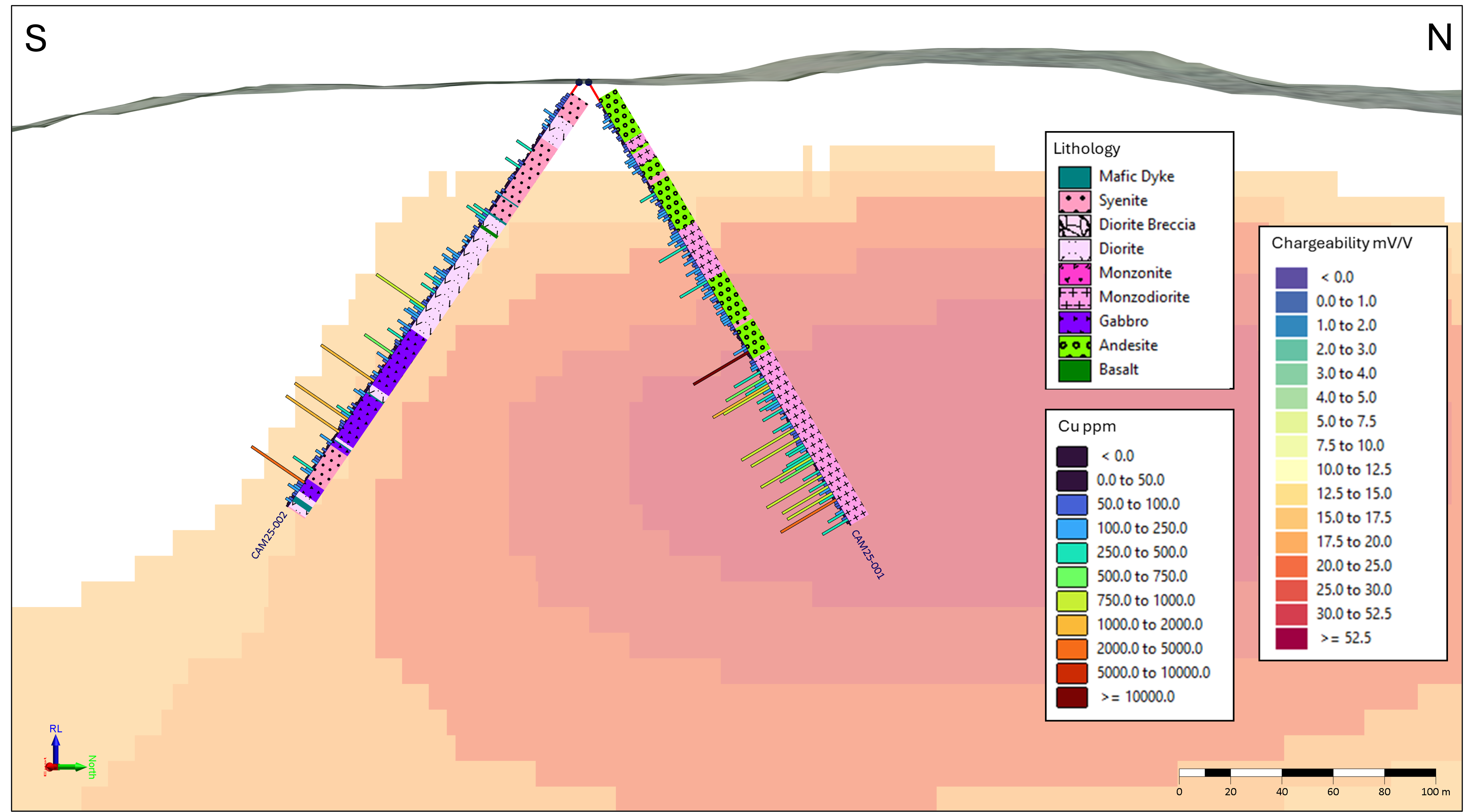
Figure 6: 100 m wide cross section, looking West and over mV/V chargeability model: CAM25-001 (right) and CAM25-002 (left), lithology plotted on the right, and ppm copper measured by pXRF on the left.
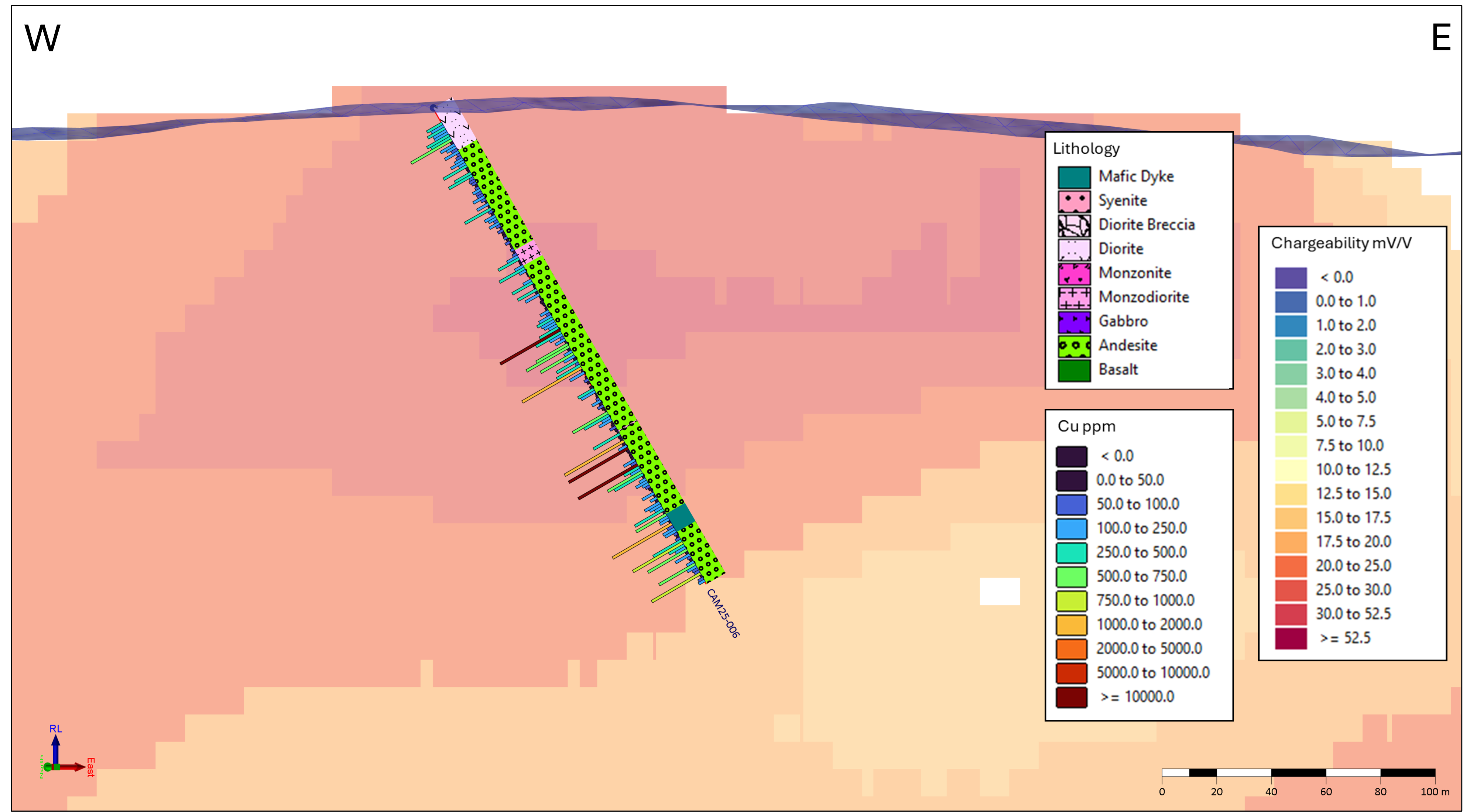
Figure 7: 100 m wide cross section looking North over mV/V chargeability model: CAM25-006, lithology plotted on the right and ppm copper measured by pXRF on the left.
About the Camelot Property
The 2,646-hectare Camelot property lies approximately 65 km east of Williams Lake, B.C. within the Quesnel Terrane - home to multiple producing copper-gold and copper-molybdenum porphyry deposits, including the nearby Gibraltar and Mount Polley mines (Figure 1). Camelot is located 34 km southeast of Imperial Metal's Mount Polley and 13 km northeast of Vizsla Copper's Woodjam project.
The project area benefits from year-round road access and excellent regional infrastructure. Previous exploration workii,iii has outlined a 1700 m x 500 m coincident chargeability-magnetic anomaly trending northeast-southwest beneath shallow till cover in an area that has not been previously drilled (Figure 3).
The property is centered on the Lemon Lake stock, a Late Triassic to Early Jurassic multi-phase pluton hosted in volcanic units of the Quesnel Terrane. The approximately 5 km wide pluton was formed by early phases of gabbro cut by younger monzonite, breccias, and late-stage syenitic dikes. Moderate K-feldspar and biotite alteration, as well as local pyrite-chalcopyrite mineralization, are primarily associated with monzonite intrusions. Zones of sericite-pyrite (or phyllic) alteration appear to be rare, consistent with the interpreted alkalic porphyry model assumed for the system.
Drill Hole Locations
The drill program is being conducted from drill pads constructed next to logging roads and fire breaks, with minimal surface disturbance. See Table 1 below for a summary of drill hole orientation and location.
Table 1: Drill hole collar locations and drill hole orientations for the first six drill holes of the 2025 diamond drilling campaign. All coordinates are in UTM NAD83 Zone 10.
Hole ID | Easting | Northing | Collar Elevation (m) | Azimuth (°) | Dip (°) | Total Depth (m) |
CAM25-001 | 616,607 | 5,801,369 | 879 | 340 | -60 | 201 |
CAM25-002 | 616,607 | 5,801,369 | 879 | 160 | -55 | 201 |
CAM25-003 | 616,303 | 5,800,855 | 875 | 290 | -50 | 201 |
CAM25-004 | 616,588 | 5,800,504 | 869 | 175 | -55 | 102 |
CAM25-005 | 617,385 | 5,801,864 | 960 | 175 | -50 | 201 |
CAM25-006 | 617,259 | 5,801,894 | 925 | 110 | -60 | 201 |
Land Acknowledgement
Prospect Ridge acknowledges that Camelot is situated within the traditional territories of the Williams Lake Indian Band, Xatsull First Nation, Whispering Pines/Clinton Indian Band, Northern Shuswap Tribal Council, and the Neskonlith Indian Band. The Company is committed to building positive, transparent, and mutually beneficial relationships with Indigenous communities founded on trust, respect, and open communication.
QA/QC (Quality Assurance/Quality Control)
Prospect Ridge's 2025 exploration program is managed by Equity Exploration Consultants Ltd. of Vancouver, B.C. The drill contractor is Dorado Drilling Ltd. of Vernon, B.C.
Core logging was done under the onsite supervision of professional geoscientists registered with EGBC and employed by Equity, a registered firm with EGBC.
Portable XRF analyses were done with an Olympus VANATA on spot samples every 1 m down the drill string. Spots were placed on representative pieces of core to avoid a selection bias of higher-grade samples. Occasional measurements of certified reference materials used for wet chemistry showed that pXRF analyses are precise. Results were exported directly from the pXRF machine into 3D modelling software.
Qualified Person Statement
All technical information that forms the basis for the written disclosure in this press release, has been approved by Ron Voordouw, Ph.D., P.Geo., Director of Geoscience for Equity Exploration Consultants Ltd., who is an independent consultant to the Company, and a qualified person as defined under the terms of National Instrument 43-101.
About Prospect Ridge Resources Corp.
Prospect Ridge Resources Corp. is a British Columbia-based exploration and development company focused on critical metals and gold. Led by a seasoned management and technical team with over 100 years of combined mineral exploration experience, Prospect Ridge is advancing its north-central B.C. located Golden Horseshoe and Cariboo projects - high-potential copper-gold systems positioned within one of Canada's most under-explored yet geologically endowed mineral belts.
Contact Information
Prospect Ridge Resources Corp.
Mike Iverson - Chairman, Director
Email: mike@miverson.ca
Sources of Technical Information
(i). Baknes, M. J. 2023. Drilling Report on the Lemon Lake Project. B.C. Mines Branch Assessment Report Event No.5993800
(ii). Britton, R., 2021 2021 Geological - hand trenching, airborne Magnetic - VLF survey and petrological reports on the Lemon Lake property B.C. Mines Branch Assessment Report 39604
(iii). Bailey, D. 2012 Lemon Lake property Horsefly Induced Polarization and Magnetometer Survey B.C. Mines Branch Assessment Report 33088.
Neither the Canadian Securities Exchange nor its Regulation Services Provider (as that term is defined in the policies of the Canadian Securities Exchange) accepts responsibility for the adequacy or accuracy of this release.
This release includes certain statements and information ("FLI") that may constitute forward-looking information within the meaning of applicable Canadian securities laws. FLI relates to future events or future performance and reflect the current expectations or beliefs of the Company's management. Anything that is not historical fact is FLI. Generally, FLI can be, without limitation, identified by the use of forward-looking wording such as "plans", "intends", "believes", "expects", "anticipates" or "estimates", and statements or phrases that certain actions, events or results "may", "might", "could", "should" or "would" occur, and similar expressions. FLI is not historical fact, is made as of the date of this news release and includes, without limitation, statements and discussions of future plans, intentions, expectations, estimates and forecasts, and statements as to management's intentions and expectations with respect to, among other things, positive exploration results at the Camelot project. FLI involves numerous risks and uncertainties, and are based on assumptions, and actual results might differ materially from results suggested in any FLI. These risks and uncertainties include, among other things, the availability of financing to continue exploration activities, the availability and cost of qualified exploration personnel and service providers, and that future exploration results at the Camelot project will not be as anticipated. In making any FLI in this news release, the Company has applied several material assumptions, including without limitation, that future exploration results at the Camelot project will be as anticipated. Although management has endeavored to evaluate and use reasonable assumptions and to identify important factors that could cause actual results to differ materially from those contained in FLI, these assumptions may prove incorrect and there may be other factors that cause results not to be as intended, expected, anticipated or estimated. There can be no assurance that FLI will prove to be accurate, and actual results and future events could differ materially from those expressed in FLI. Accordingly, readers should not place undue reliance on FLI, and are further cautioned that reliance on such information may not be appropriate for other purposes. The Company does not undertake to update any FLI expressed or incorporated by reference herein, except in accordance with applicable securities laws. We seek safe harbor.
SOURCE: Prospect Ridge Resources Corp
View the original press release on ACCESS Newswire:
https://www.accessnewswire.com/newsroom/en/metals-and-mining/prospect-ridge-detects-copper-mineralization-in-four-of-first-six-diamond-drill-h-1114598