

Key Highlights
- New multi-kilometre gold trend defined along the Branch Fault Corridor, a major structural setting with minimal historical drilling and a previous intercept of gold nearby.
- Broader Nitty Gritty area emerging as a polymetallic opportunity, with elevated copper, lead, zinc and silver responses supported by historical high-grade surface samples.
- Re-logging at Nitty Gritty identifies previously unrecognised intrusions, providing a new geological framework for follow-up work and re-evaluation of past drilling.
- Priority target zone established at Bunker Hill West, aligned with northwest-southeast structural trends now seen repeatedly across the project.
- Target areas developing to the north and southeast, indicating broader system scale and strengthening the district-wide structural interpretation.
- 2026 work to prioritise high-conviction drill targets, focusing capital where geological confidence, scale potential and structural control are strongest.
- Assays remain pending, on the Isle aux Morts Granite and Hermitage geochemical surveys and diamond drilling results from Cape Ray are all expected later in the first quarter of 2026.
Edmonton, Alberta--(Newsfile Corp. - January 8, 2026) - AuMEGA Metals Ltd (ASX: AAM) (TSXV: AUM) (OTCQB: AUMMF) ("AuMEGA" or "the Company") is pleased to report encouraging results from its 2025 till geochemistry and geological mapping program at the Bunker Hill Project ("Bunker Hill"), part of the Company's 110-kilometre district-scale landholding along the Cape Ray Shear Zone ("CRSZ") in southwestern Newfoundland, Canada.
The program has provided a clearer understanding of where gold and base metals are most likely being sourced within the system and has highlighted several areas that remain significantly underexplored relative to their scale. These results strengthen confidence in prioritising future drill targets and support a disciplined, high-conviction approach to capital deployment.
AuMEGA Metal's Managing Director and CEO, Sam Pazuki commented:
"The winter drilling at Bunker Hill in the first quarter of 2025 gave us a starting point. The surficial geochemistry has filled in the missing context and provided more encouraging data. We are dealing with a much larger, more connected system than originally interpreted. We're now seeing multiple and broad gold and base metals responses along major structural corridors that are significantly underexplored.
"What stands out is how the new data ties together with previous data from the limited drilling and historic exploration work with entirely new, previously unrecognised trends emerging. This has expanded our opportunities and tightened our focus whereby we're not just adding targets, we're upgrading the quality of the targets.
"The broader Nitty Gritty area is the best example of that shift. While earlier drilling didn't return economic hits, the re-logging has revealed intrusive textures that were missed the first time around. Combine that with elevated copper, lead, zinc and silver responses and historical high-grade surface till and grab samples, and it's emerging as a legitimate polymetallic opportunity. That changes the conversation for this part of the project.
"We are integrating the entire 2025 dataset, ranking our growing list of targets, and positioning ourselves for focused drill programs in 2026. The work completed last year has materially increased our confidence in where capital should be deployed, and we're now in a stronger position to pursue a more meaningful outcome at Bunker Hill."
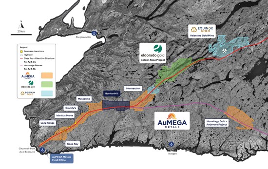
Figure 1: AuMEGA Metals portfolio on the Cape Ray Shear Zone and Hermitage Flexure
To view an enhanced version of this graphic, please visit:
https://images.newsfilecorp.com/files/10713/279789_83e5f0f7f4699994_002full.jpg
2025 Bunker Hill Surficial Till Survey Overview
The 2025 surficial geochemistry program outlined several prospective gold zones, reinforcing the potential for Bunker Hill to host a larger system than has historically been tested. The program totaled 2,812 samples over 3,301 stations. The majority of the survey grid was sampled on a 160 X 80 metre spaced grid while the area in the southeast of Bunker Hill was completed at a 640 X 80 metre spaced grid to assess regional prospectivity (Figure 2). This work was completed alongside geological mapping and rock sampling, complementing the Company's 2024 airborne magnetics program1.
The objective was to build an integrated dataset to refine and rank the most credible areas for future drilling. The findings have highlighted multiple gold-in-till responses that validate the prospectivity of the area and improve targeting confidence.
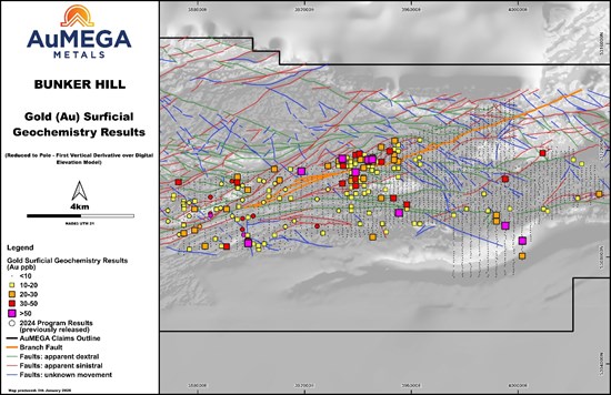
Figure 2: Surficial geochemical program results for the 2025 Bunker Hill campaign. The figure shows all gold-in-till results overlying the greyscale reduced to pole - first vertical derivative magnetics with a digital elevation model background.
To view an enhanced version of this graphic, please visit:
https://images.newsfilecorp.com/files/10713/279789_83e5f0f7f4699994_003full.jpg
Branch Fault Corridor
The most significant outcome of the 2025 work is the definition of a multi-kilometre gold trend associated with the Branch Fault and related splays, a major structural setting linked to the CRSZ (Figure 3). Despite its scale and proximity to a previous drill intercept of 1.84 g/t gold over one metre (CRD3962), this target area has seen only three historical drill holes3. The strength and continuity of the gold response suggest a meaningful source area that remains untested.
Gold responses are strongest where these splays intersect northwest-trending structural lineaments - a pattern evident across several parts of the project. The corridor remains open to the north, where survey coverage was limited by seasonal access.
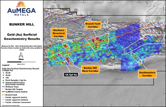
Figure 3: Gold-in-till results from Bunker Hill. The figure shows gridded gold-in-till results overlying the greyscale reduced to pole - first vertical derivative magnetics. The gold-in-till results are filtered to >20 ppb gold.
To view an enhanced version of this graphic, please visit:
https://images.newsfilecorp.com/files/10713/279789_83e5f0f7f4699994_004full.jpg
Nitty Gritty - Base Metals Target Zone with Polymetallic Potential
The 2025 program has also continued to highlight the prospectivity of the Nitty Gritty area, located in the central-eastern portion of the Bunker Hill till survey grid. This zone is characterised by a consistent cluster of elevated base metals such as copper (Cu), lead (Pb), zinc (Zn) and silver (Ag) values across multiple till survey lines (Figures 4 - 7), as well as historical high-grade copper (including 57% copper) and silver samples (including 407.5 g/t silver)4 reported from surface.
A total of only six diamond drill holes were completed by AuMEGA in the immediate area. While these holes did not return economic intercepts5, recent re-logging and reinterpretation of the core has identified previously unrecognised intrusive-related textures that were not incorporated into the original geological model. This materially changes the understanding of the system and provides a new framework for follow-up.
This emerging base-metals opportunity is supported by:
Multi-element responses (Pb-Cu-Zn-Ag) occurring along a northeast striking geophysical lineament, indicating a coherent target rather than isolated values;
Historical, high-grade copper and silver samples in proximity to the current geochemical cluster; and,
Minimal drilling relative to the scale of the target and drilling previously oriented without the benefit of the updated structural and intrusive model.
While still early-stage, Nitty Gritty represents a new dimension of potential at Bunker Hill, expanding the opportunity beyond orogenic-style gold. The Company intends to include this area in its 2026 targeting review for potential intrusive-focused or polymetallic testing.
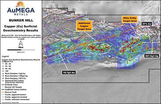
Figure 4: Copper-in-till results from Bunker Hill. The figure contains gridded copper-in-till results overlying the greyscale reduced to pole - first vertical derivative magnetics. Results are filtered to >28 ppm copper.
To view an enhanced version of this graphic, please visit:
https://images.newsfilecorp.com/files/10713/279789_83e5f0f7f4699994_005full.jpg
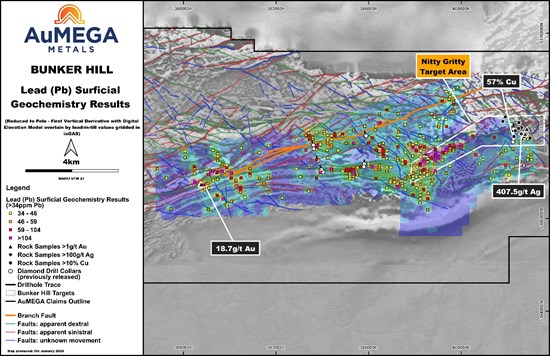
Figure 5: Lead-in-till results from Bunker Hill. The figure contains gridded lead-in-till results overlying the greyscale reduced to pole - first vertical derivative magnetics. Results are filtered to >34 ppm lead.
To view an enhanced version of this graphic, please visit:
https://images.newsfilecorp.com/files/10713/279789_83e5f0f7f4699994_006full.jpg
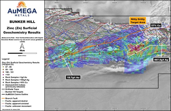
Figure 6: Zinc-in-till results from Bunker Hill. The figure shows gridded zinc-in-till results overlying the greyscale reduced to pole - first vertical derivative magnetics. Results are filtered to >67 ppm zinc.
To view an enhanced version of this graphic, please visit:
https://images.newsfilecorp.com/files/10713/279789_83e5f0f7f4699994_007full.jpg
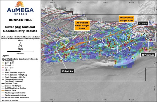
Figure 7: Silver-in-till results from Bunker Hill. The figure contains gridded silver-in-till overlying the greyscale reduced to pole - fist vertical derivative magnetics. Results are filtered to >0.07ppm silver.
To view an enhanced version of this graphic, please visit:
https://images.newsfilecorp.com/files/10713/279789_83e5f0f7f4699994_008full.jpg
Bunker Hill West Corridor - Continuity and New Target Areas
Approximately one kilometre southeast of the historic 18.7 g/t gold rock grab sample6), the 2025 surficial geochemistry program defined a priority target zone with a clear spatial relationship to a northwest-southeast structural trend. This same orientation is now being observed across multiple areas at Bunker Hill (Figures 2 and 3).
This structural setting is interpreted to have created favourable conditions for mineralised fluid flow and concentration. The repeatability of this orientation across the property represents a shift from earlier models and elevates this area as a priority for future work.
North & Southeast Corridor
To the north of the Branch Fault, an emerging structural target, Northern Structural Corridor, is developing along the same northwest trend (Figure 3). In the southeast, a reconnaissance-scale survey has defined an early-stage target, named Southeastern Corridor, providing the foundation for broader follow-up (Figure 3).
Ongoing Work and Next Steps
AuMEGA is now integrating all datasets to rank and prioritise the strongest target areas for 2026 drilling. The focus remains on zones that show scale, repeatable structural controls, and consistent gold responses, with the goal of increasing drill success and improving capital efficiency.
The Company intends to:
Extend till sampling and mapping north of the Branch Fault to expand the Branch Fault corridor;
Complete a regional surficial geochemistry survey eastwards from the 2025 survey boundary towards the Intersection Prospect to evaluate district-scale continuity (Figures 1 and 2);
Detailed geological mapping at a 1:5000 scale, and channel sampling over the anomalies to define drill targets for the 2026 drilling campaign; and,
Advance a focused diamond drilling program in summer 2026, testing a select group of high-conviction target areas rather than broad early-stage coverage.
These steps support a systematic advancement of the most compelling opportunities within the portfolio while maintaining flexibility and discipline in current market conditions.
< END >
This announcement has been authorised for release by the Company's Board of Directors.
To learn more about the Company, please visit www.aumegametals.com, or contact:
Sam Pazuki, Managing Director & CEO
Canada Phone: +1 780 665 4925
Australia Phone: +61 8 6117 0478
Email: info@aumegametals.com
About the Company
AuMEGA Metals Ltd (ASX: AAM) (TSXV: AUM) (OTCQB: AUMMF) is utilising best-in-class exploration to explore on its district scale land package that spans 110 kilometers along the Cape Ray-Valentine Shear Zone, a significant under-explored geological feature recognised as Newfoundland, Canada's largest identified gold structure. This zone currently hosts Equinox Gold's Valentine Gold Project, a multi-million-ounce deposit which is the region's largest gold project, along with AuMEGA's expanding Mineral Resource.
The Company is supported by a diverse shareholder registry of prominent global institutional investors, and strategic investment from B2Gold Corp, a significant, intermediate gold producer.
Additionally, AuMEGA holds a 27-kilometre stretch of the highly prospective Hermitage Flexure and has also secured an Option Agreement for the Blue Cove Copper Project in southeastern Newfoundland, which exhibits strong potential for copper and other base metals.
AuMEGA's Cape Ray Shear Zone hosts several dozen high potential targets along with its existing defined gold Mineral Resource of 6.2 million tonnes grading an average of 2.25 g/t gold, totaling 450,000 ounces of Indicated Resources, and 3.4 million tonnes grading an average of 1.44 g/t gold, totaling 160,000 ounces in Inferred Resources7.
AuMEGA acknowledges the financial support of the Junior Exploration Assistance Program, Department of Industry, Energy and Technology, Provincial Government of Newfoundland and Labrador, Canada.
Reference to Previous Announcements
In relation to this news release, all data used to assess targets have been previously disclosed by the Company and referenced in previous JORC Table 1 releases. Please see announcements dated: 14 April 2021, 22 March 2023, 30 May 2023, 24 September 2024, 15 October 2024, 26 May 2025 and 29 July 2025. In relation to the Mineral Resource estimate announced on 30 May 2023, the Company confirms that all material assumptions and technical parameters underpinning the estimates in that announcement continue to apply and have not materially changed. The Company confirms that the form and context in which the Competent Person's findings are presented have not been materially modified from the original market announcement.
Competent Person's Statements
Till Sampling
All till samples are collected using a hand auger to collect roughly 2 kg of material, the 'C-Horizon' is targeted but the 'B-Horizon' is collected where this is not possible. Notes are taken on the sample horizon as well as the sand vs silt fractions and moisture content. Samples are then sealed in pre-marked calico bags. Till samples are organized at the Company's facilities in Channel Port-aux-Basques, NL., before they are driven by company personnel to Eastern Analytical's facilities in Springdale, NL., for drying at 60°C and sieving to -63 µm. The dried and sieved fraction is then shipped to ALS Global ("ALS") facilities in Vancouver, BC where they undergo ICP-MS for 53 elements after an aqua regia digestion. All QA/QC data is reviewed by the Database Manager, Exploration Manager and/or Competent Person to ensure quality of assays. Batches containing multiple CRMs that report outside of two standard deviations from expected values are re-assayed. Both Eastern Analytical and ALS are ISO certified and are independent from the company.
Historic Data
Some data disclosed in this news release is related to historical sampling. The Company has not independently analyzed the results in order to verify the results; however, the Company considers these historical results relevant as the Company is using this data as a guide to plan exploration programs.
Qualified Person
The scientific and technical information in this press release was reviewed and approved by Shamus Duff, P. Geo., Project Geologist. Mr. Duff is a Qualified Person as defined under National Instrument 43-101 and a Professional Geologist registered with Professional Engineers and Geoscientists of Newfoundland and Labrador (PEGNL). Mr. Duff consents to the publication of this press release and certifies that the information is provided fairly and accurately represents the scientific and technical information disclosed within it.
1 News Release 15 October 2024
2 News Release 26 May 2025
3 News Release 29 July 2025
4 News Releases 15 October 2024, 24 September 2024, 22 March 2023 and 14 April 2021
5 News Release 26 May 2025 and 29 July 2025
6 News Release 22 March 2023 and 24 September 2024
7 News release dated 30 May 2023
![]()
To view the source version of this press release, please visit https://www.newsfilecorp.com/release/279789
Source: AuMEGA Metals Ltd.

