Kamloops, British Columbia--(Newsfile Corp. - January 20, 2026) - North Valley Resources Ltd. (CSE: NVR) ("North Valley" or "The Company") is pleased to share new compilation and interpretation work for its fully-permitted Comstock Project, located near Merritt in southern British Columbia (Figure 1). Spanning 4,462 hectares and encompassing 33 highly mineralized historic showings, the Comstock Project represents the first consolidation of this extensive, district-scale copper system under a single company. Building on encouraging historic drilling (1988) at the Original-Diane Zone, recent geological modeling has identified high-priority geophysical targets that were previously unknown to the 1988 drill program, offering significant, untested copper-gold potential at depth in a region adjacent to some of British Columbia's most productive copper mines.
The limited 1988 drill program at the Original-Diane Zone was conducted during a period of depressed copper prices, which constrained exploration budgets. As a result, several intercepts reporting copper values exceeding 1.0% were never re-assayed and only 22% of the drill core was sampled. Despite the shallow drilling and limited analytical work at the time, the program returned encouraging copper and gold intercepts, underscoring the strong underlying potential of the Original-Diane Zone.
The Comstock Gold-Copper property is located adjacent to the Coquihalla highway, 10 kms south of Merritt, B.C. Nearby mines include Teck Resources' Highland Valley Copper Mine, Hudbay Minerals' Copper Mountain Mine, and New Gold's New Afton Mine. Recent discoveries in proximity to the Comstock property include Kodiak Copper's MPD Property (approx. 15 kms to the southeast) and Westhaven Gold's Shovelnose Property (approx. 13 km to the south)1.
Ken Ellerbeck, CEO of North Valley Resources, states: "With a 100-site drill permit now secured, the Company is well positioned to advance follow-up drilling on the historic work and assess the continuity of copper-gold mineralization at depth. This program will also target recently identified geophysical anomalies beneath the Original-Diane and South zones, providing a clear path to unlocking the Project's deeper exploration potential."
Strategic Location in a Proven Mining District
The Comstock Project is located in the heart of southern B.C.'s premier mining country, at the crossroads of the established Quesnel Terrane and the emerging Spences Bridge Gold Belt; a unique geological setting that supports epithermal gold and porphyry copper-gold deposit potential.
The property benefits from exceptional access and infrastructure, including proximity to the Coquihalla Highway, existing internal road networks, and year-round exploration capability. The project lies within trucking distance of multiple producing mines and milling facilities, including Highland Valley Mine (Anglo Teck), New Afton Mine (New Gold), and Copper Mountain (Hudbay), which significantly reduces exploration and potential development risk (Figure 1).
Compelling Geological Upside
Comstock is situated within the Western portion of the Nicola Volcanic Group, a highly fertile geological package within the Quesnel Terrane that hosts some of British Columbia's largest copper-gold porphyry systems. Recent work on the Comstock property has identified a ~8 km x 3 km mineralized corridor that shares many geological and geophysical similarities with neighboring copper-gold porphyry and epithermal-gold systems within the Quesnel Terrane of British Columbia.
High-Grade Historic Results with Minimal Modern Follow-Up
Rock Assays
Mineralization is commonly hosted in quartz veins containing specular hematite, chalcopyrite, bornite, and copper oxides. Fourteen separate showings have returned copper assays exceeding 1.0% Cu; however, most results are moderate, and the highest reported values of 27.1% Cu are isolated and considered anomalous. Eight showings report gold assays greater than 2.0 g/t Au, with a small number of samples yielding unusually high values, including four showings exceeding 19 g/t Au and a maximum reported assay of 56 g/t Au. Visible gold has been observed locally within the historic Original-Diane showing.
Historic Drilling
The Comstock property has undergone only limited shallow drilling to date. In 1988, a nine-hole drill program totaling 570 metres was completed at the Original-Diane showing. The drilling reached a maximum depth of approximately 90 metres and returned several encouraging high-grade copper and gold intercepts (Table 1).
The project was abandoned not due to geology, but as a result of collapsing copper prices and the closure of the nearby Craigmont Mine, leaving a high-quality asset dormant for decades.
The 1988 drill program intersected fractured, mineralized zones characterized by quartz and silicified volcanics, with widespread limonite boxwork and patchy pyrite overprinting chloritic volcanics containing specular hematite. The quartz veins consist of fine-grained quartz and coarser quartz within a cherty interstitial phase. North Valley interprets these veins as potentially forming within the lithocap of an underlying mineralized porphyry system. The veins exhibit features consistent with late-stage, low-sulfidation veins that can overprint earlier stockwork and porphyry-style mineralization. This geological association underscores the potential for higher-grade copper and gold mineralization and supports the case for systematic drilling to test the broader porphyry target.
Table 1: Results obtained from Nelles, 1988 (AR17721). *Drill core assays were capped at 10,000 ppm Cu (1%) and approximately only 22% of the total 570 metres of core was assayed.
| Drillhole ID | Length (m) | Interval (m)2 | Grade |
| DDH 88-1 | 68.28 | 58.97-67.66 | 0.20% Cu and 2.65 g/t Au over 8.69 m, incl. 24.7 g/t Au over 0.76 m |
| DDH 88-2 | 76.96 | 61.08-74.64 | 0.38% Cu and 0.72 g/t Au over 13.99 m, incl. 0.71% Cu over 3.05 m |
| DDH 88-3 | 90.83 | 69.19-90.22 | 0.17% Cu and 0.18 g/t Au over 21.03 m, incl. 0.39% Cu over 2.95 m |
| DDH 88-4 | 56.69 | 36.88-49.68 | 0.53% Cu and 0.36 g/t Au over 12.80 m |
| DDH 88-5 | 47.83 | 39.32-47.55 | 0.49% Cu and 0.52 g/t Au over 8.23 m |
| DDH 88-6 | 56.69 | 12.19-16.76 | 0.41% Cu and 0.14 g/t Au over 4.57 m |
| 45.72-53.04 | 0.11% Cu and 0.07 g/t Au over 7.32 m | ||
| DDH 88-7 | 80.16 | 13.72-17.68 | 0.57% Cu and 0.32 g/t Au over 3.96 m |
| 59.59-62.99 | 0.12% Cu and 0.07 g/t Au over 3.4 m | ||
| 74.22-78.35 | 0.13% Cu and 0.07 g/t Au over 4.13 m | ||
| DDH 88-8 | 55.47 | 12.95-18.29 | 0.22% Cu and 1.09 g/t Au over 5.34 m |
| 21.18-26.37 | 0.28% Cu and 0.09 g/t Au over 5.19 m | ||
| 47.85-49.38 | 0.11% Cu and 0.07 g/t Au over 3.05 m | ||
| 52.43-53.65 | 0.96% Cu and 0.07 g/t Au over 1.22 m | ||
| DDH 88-9 | 37.03 | 12.65-18.59 | 0.16% Cu and 0.61 g/t Au over 5.94 m |
| 20.42-22.86 | 0.34% Cu and 0.11 g/t Au over 2.44 m | ||
| Total | 569.94 |
Modern Exploration Unlocks District Potential
Between 2021 and 2025, the Comstock Project advanced significantly with the completion of final claim consolidation, followed by the first comprehensive magnetic and induced-polarization (IP) geophysical surveys across the property. These geophysical surveys revealed multiple previously unrecognized magnetic and induced polarization (IP) anomalies, highlighted by a robust chargeability anomaly exceeding 400 m in strike length (Figure 2). The anomaly is positioned beneath the Original-Diane zone and remains open to the southwest of the historic 1988 drill program (Figure 3), indicating strong potential for expansion. Importantly, the chargeability feature extends into the South Zone, where historic trench sampling returned encouraging copper grades of 0.45% Cu over 2 m and 0.20% Cu over 7 m2 (Assessment Report 16058). Recent fieldwork has further validated the presence of mineralization and alteration characteristic of porphyry and epithermal systems, reinforcing the project's compelling discovery potential.
This modern data provides a clear roadmap for systematic, target-driven exploration, with multiple high-priority zones emerging for follow-up drilling.
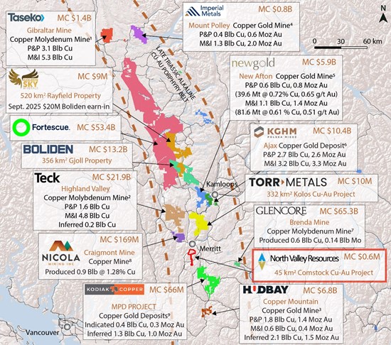
Figure 1: The 4,462-hectare Comstock Cu-Au property is located within the Quesnel Terrane, British Columbia's most productive copper-producing belt. 1 Gibraltar: Taseko Reserves and Resources Website Information, accessed August 21, 2025. 2 Highland Valley: Teck Mineral P&P, M&I, Inferred Resources Annual Information for February 23, 2022 (Teck.com). 3 Copper Mountain: Mineral Reserves and Resources as of January 1, 2025 (hudbayminerals.com). 4 Mount Polley: Imperial Metals P&P, M&I, Inferred Resources Reserves and Resources; Website Information, dated June, 2023 (www.imperialmetals.com). 5 New Afton: NI 43-101 Technical Report. Effective Date December 31, 2024 (newgold.com). 6 Ajax: KGHM Mineral Resources and Reserves Report. as of December 31, 2014 (kghm.com). 7 Weeks et al., 2003. The Brenda Mine in Porphyry Copper Deposits of the Calc-Alkalic Suite Paper 9 of the Porphyry Deposits of Northwestern Cordillera of North America, CIM Special Volume 46, pp 192-200. 8 Wells KW, Gray JG. 2020. NI 43-101 Technical Report on the Preliminary Copper Resource for the Southern Dump and 3060 Portal Dumps. Effective Date May 21, 2020 (nicolamining.com). 9 Rodriguez et al. 2025. Technical Report and Mineral Resource Estimate MPD Project British Columbia, Canada. Effective date June 25, 2025. (kodiakcoppercorp.com) *Information and comparisons disclosed is not necessarily indicative of precious or base metal endowment or assays on the Comstock
To view an enhanced version of this graphic, please visit:
https://images.newsfilecorp.com/files/8168/280894_db936de164971823_001full.jpg
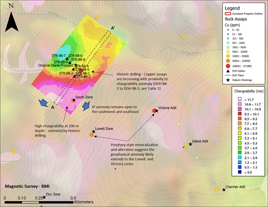
Figure 2: 1988 historic drill collar locations at the Original-Diane zone with underlying IP geophysical survey completed in 2020. Modern geophysical data outlines a significant chargeability anomaly exists below historic drilling that remains open to the southwest and southeast. The Lowell zone and Victoria Adit occur along the edges of a magnetic anomaly, which may correspond to the intrusion that drove mineralization.
To view an enhanced version of this graphic, please visit:
https://images.newsfilecorp.com/files/8168/280894_db936de164971823_002full.jpg
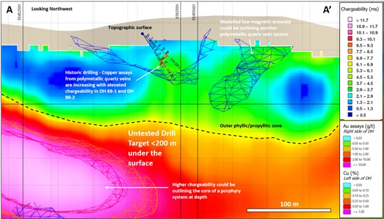
Figure 3: Cross-section (see Figure 2) demonstrates the close relationship between mineralization and elevated chargeability. It is interpreted that the 1988 historic drilling may have intersected the outer propylitic/phyllic zone of an underlying porphyry system. The higher chargeability may be outlining the core of a porphyry system and represents a compelling, near-surface target for future drill programs.
To view an enhanced version of this graphic, please visit:
https://images.newsfilecorp.com/files/8168/280894_db936de164971823_003full.jpg
About North Valley Resources
North Valley Resources is a well-positioned junior exploration company focused on advancing its flagship Comstock Project, a high-quality exploration asset that is fully permitted for drilling and located in a proven, mining-friendly jurisdiction. The Company is executing a disciplined, systematic exploration strategy aimed at unlocking significant copper and gold potential and advancing Comstock toward the mineral resource stage, while creating meaningful value for shareholders.
More information can be found at the Company's website at www.northvalleyresources.ca.
Qualified Person
The technical content of this news release and the Company's technical disclosure has been reviewed and approved by Kris Raffle, P.Geo., an independent contractor of the Company, who is a qualified person as defined by National Instrument 43-101 Standards of Disclosure for Mineral Projects.
For further information on the Company's programs, please visit North Valley's website at www.northvalleyresources.ca or contact Quinn Ellerbeck, CFO, Director at quinn@lacombeventures.com.
Forward-Looking Statements
This press release may contain "forward-looking information or statements" within the meaning of Canadian securities laws, which may include, but are not limited to statements relating to its future business plans. All statements in this release, other than statements of historical facts, that address events or developments that the Company expects to occur, are forward-looking statements. Forward-looking statements are statements that are not historical facts and are generally, but not always, identified by the words "expects", "plans", "anticipates", "believes", "intends", "estimates", "projects", "potential" and similar expressions, or that events or conditions "will", "would", "may", "could" or "should" occur. Although the Company believes the expectations expressed in such forward-looking statements are based on reasonable assumptions, such statements are not guarantees of future performance and actual results may differ from those in the forward-looking statements. Such forward-looking information reflects the Company's views with respect to future events and is subject to risks, uncertainties and assumptions. The Company does not undertake to update forward-looking statements or forward-looking information, except as required by law. Neither Canadian Securities Exchange nor its regulation services provider accepts responsibility for the adequacy or accuracy of this release.
References
Cavey, G. et al. 1986. Report on Detailed Geological, Geochemical, and Geophysical Surveys for International Maple Leaf Resource Corporation on the Stirling Group (Diane 1-5 Mineral Claims). BC Geological Survey Assessment Report 16058.
Nelles, D.M. 1988. Diamond Drilling Report on the Stirling Group (Diane 1-5 Mineral Claims) for Abermin Corporation. BC Geological Survey Assessment Report 17721.
1 Mineralization present on adjacent properties is not necessarily representative within the Comstock Property.
2 The estimated true width of mineralization is unknown.
NOT FOR DISTRIBUTION TO U.S. NEWSWIRE SERVICES OR FOR DISSEMINATION IN THE UNITED STATES.
![]()
To view the source version of this press release, please visit https://www.newsfilecorp.com/release/280894
Source: North Valley Resources Ltd.
