

2026 Exploration Program Update
TORONTO, ON / ACCESS Newswire / May 27, 2026 / Copper Road Resources Inc. (TSXV:CRD) ("Copper Road" or the "Company") is pleased to provide an update for its on-going and planned 2026 Exploration work program over its Ben Nevis Volcanic Complex ("BNVC") project, located in the Kirkland Lake-Larder Lake area of northeastern, Ontario.
The consolidated claim package consists of 174 mining claim cells covering 10,693 hectares ("ha"), including 13 contiguous mining rights only patents for an additional 210 ha to the operational project area. The project area includes parts of Ben Nevis, Clifford, Elliott, Arnold and Katrine townships, within the prolific mineral endowed Blake River Group, Abitibi Greenstone Belt. For details on the property acquisition, the reader is referred to the December 8, 2025 press release announcing the signing of four separate option agreements available on the Copper Road website at www.copperroadresources.ca or www.sedarplus.ca. (See Figure 1).
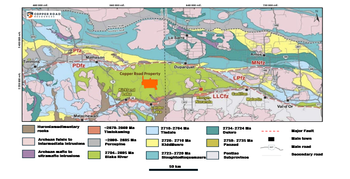
Figure 1: Regional location Map of the Copper Road Ben Nevis Volcanic Complex Project showing the Blake River Group bounded to the south by the Larder Lake-Cadillac fault zone (LLCfz) and to the north by the Porcupine Destor fault zone (PDfz) - Source: Modified after Monecke et al., 2017; Expert Geophysics, February 2026.
Copper Road is well funded for its 2026 exploration program with $2.1 million raised following the closing of three separate non-brokered private placements on December 31, 2025, March 16, 2026 and May 4, 2026. In addition, the Company current holds 1.86 million shares of Sterling Metals Corp. with a market valuation of $2.1 million as of the date of this press release.
2026 Exploration Program Update:
The 3D inversion and interpretation of the Mobile MagnetoTellurics ("MobileMT") survey data was completed as part of the Phase I exploration program, as outlined in the February 12, 2026 press release.
Copper Road selected the Expert Geophysics MobileMT system over other electromagnetic ("EM") methods because it provides deep-penetrating resistivity imaging from near surface to depths greater than 1 km, depending on the resistivity of the underlying rock units. This depth of investigation is significantly greater than that of many conventional helicopter-borne EM systems.
The objective of the survey was to enhance the search radius to depths previously untested and not evaluated by the previous exploration companies whose focus was on the known surface mineralized zones previously identified by prospectors at the Canagau Shaft and Clifford Stock areas of interest ("AOI's").
In addition, the updated 3D inversion and modelling of the MobileMT dataset completed by Computation Geosciences improved the resolution of deep conductivity features across the property.
The MobileMT survey lines are oriented N-S (N 0° E) at 100 m spacing, while tie lines are oriented perpendicular to the survey lines and spaced at 1,000 m. A total of 13 production flights were flown to complete 1,215 line-kilometres of the survey over a 109 sq.km area.
MobileMT Interpretation:
Seven (7) untested deep-seated conductors were identified in the inverted and modelled dataset:
Copper Road engaged consulting geophysicist Marc Auclair, P.Geo., to compile and interpret historical ground and airborne geophysical surveys together with the new state-of-the-art MobileMT dataset across the consolidated property package.
The mandate is to define targets for detailed geological and geophysical follow-up and, where warranted, to support additional processing and modelling of legacy datasets. The objective is to identify drill targets for testing in Copper Road's maiden diamond drill program at the BNVC property.
According to Marc Auclair, P.Geo., consulting geophysicist to the Company, the updated 3D modelling of the MobileMT dataset provides significantly improved resolution of the project's deep conductivity framework, with high-conductivity zones outlined to depths greater than 800 metres.
Interpretation of the MobileMT data outlines multiple conductive trends, magnetic lineaments and anomalies, and a complex fault network that helps define controls on mineralization and refine targeting. Integration of historical geophysical datasets, including a GEOTEM airborne survey and several ground TDEM surveys, strengthens the interpretation and positioning of the conductors.
Seven (7), high-priority, deep-seated conductors have been identified on the consolidated property holdings:
One along a northwest-trending fault that hosts the Canagau Shaft AOI - VMS Target
Two along the NE-SW trending Murdoch Creek Fault - Gold Target
One near the Croxall Breccia showings - Clifford Stock AOI - VMS Target
Three in unexplored areas in the north-central and northwest sectors of the property - VMS Targets
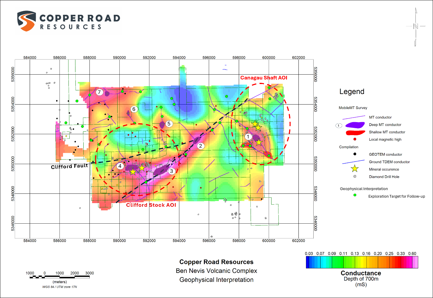
1: A deep conductor has been identified below the Canagau shaft AOI at an approximate depth of 700 metres. Although it lies near existing deep boreholes (CAN-97-001, CAN-98-003, CAN-98-004, and WBN-003), it has not been directly intersected. Detection from an airborne survey at this depth suggests a feature of meaningful size and conductance. The target lies directly below and southwest of the Canagau shaft, along the southwestern rhyolite contact and a northwest-trending fault, a favourable setting for a VMS deposit. The approximate length of the conductive zone is 600 metres.
Furthermore, the MobileMT data identified two separate near surface conductors. The first is delineated approximately 600 metres southwest of the deep conductor along a sub-parallel northwest-trending fault. The second shallow conductor is delineated approximately 1,300 metres to the southeast of the deep conductor, along the same northwest-trending structure at the junction with the sub-parallel fault.
2: An untested, deep-seated conductor occurs along the Murdoch Creek fault zone at the intersection of a north-south dyke and a northwest-trending conductive trend. The area shows strong conductivity in both the MobileMT and GEOTEM (OGS survey) datasets and appears to mark the intersection of multiple structures. The approximate length of the conductive zone is 600 metres.
3: A large, deep-seated, strongly conductive zone extending more than 2 kilometres has been identified along the Murdoch Creek fault beneath Verna Lake. The conductor is cut by a northwest-trending dyke and remains untested. The approximate length of the conductive zone is 2,200 metres.
4: A significant conductor has been identified within the Clifford Stock near the Croxall Breccia and Snipe-Brett occurrences to the south and southeast. Existing drill holes in the area tested its peripheries but did not test the conductor at depth. The conductive zone lies within a magnetic high associated with the Clifford intrusive feature and is cut by a northwest-trending fault. The approximate length of the conductive zone is 800 metres.
5: An untested, localized conductor with good vertical continuity has been identified in an unexplored area in the north-central part of the property. The approximate length of the conductive zone is 400 metres.
6: A deep-seated MobileMT conductor has been identified in a structurally complex area cut by northwest and northeast-trending features. The conductor has been identified in an unexplored area in the northwestern part of the property. No recorded drillholes have tested its potential. The approximate length of the conductor zone is 300 metres.
7: An untested, deep-seated MobileMT conductor occurs at the intersection of an east-west conductive trend and a northwest-trending dyke. The conductor has been identified in an unexplored area in the northwestern part of the property. The approximate length of the conductive zone is 300 metres.
Based on the geophysical compilation and interpretation completed to date, Copper Road has identified thirty-six (36) exploration targets for follow-up, including the seven high-priority conductors described above. These targets were selected based on the spatial association of conductive features, magnetic responses, and interpreted fault structures, together with a CET Center for Exploration Targeting ("CET") grid analysis of the magnetic data to highlight areas of structural complexity.
Figures 1-6 outline the location of the MobileMT conductors on the property, featuring the property geology and various magnetic and conductance slices at depths at 300 metres, 500 metres and 700 metres.
Figure 1: Property Geological Base
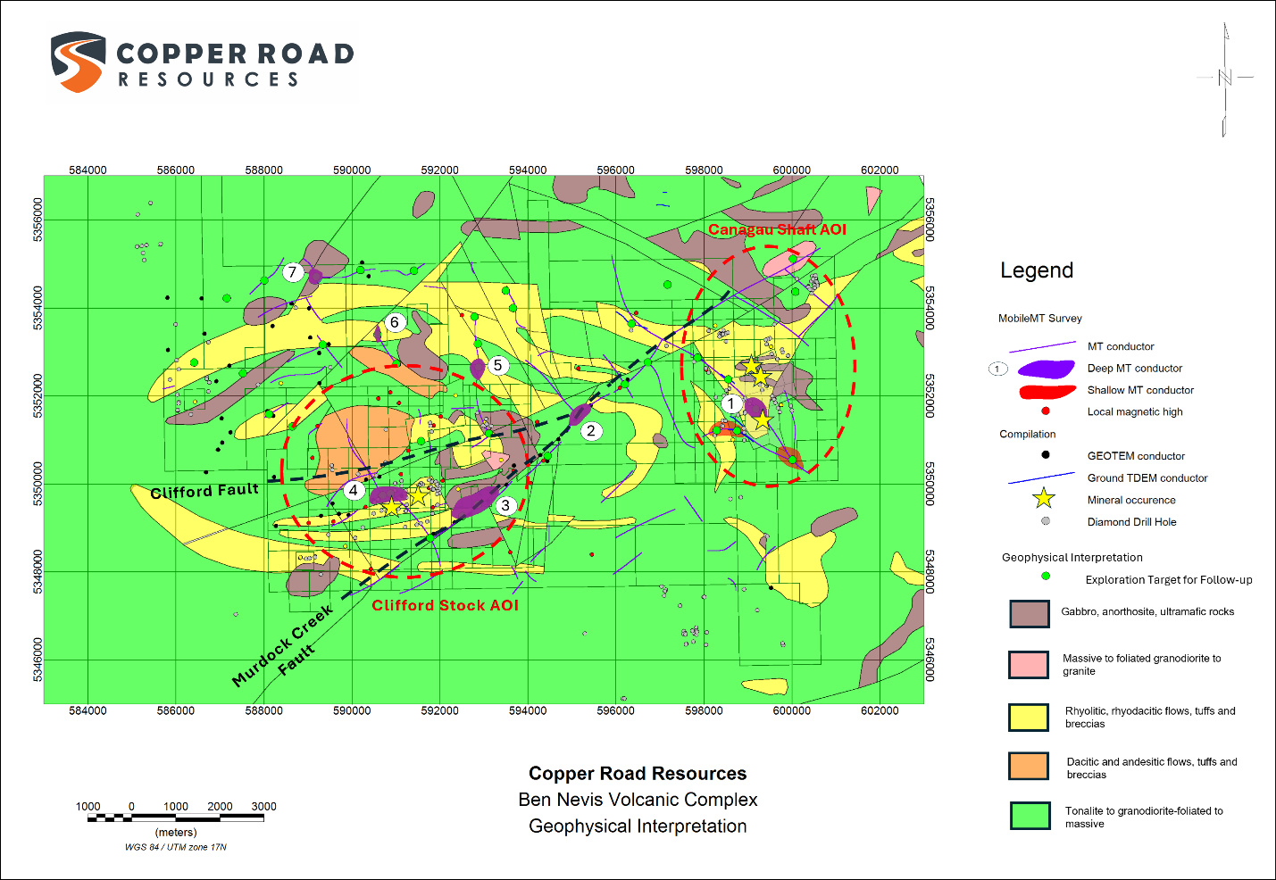
Figure 2: Residual Magnetic Field - Reduced to Poles
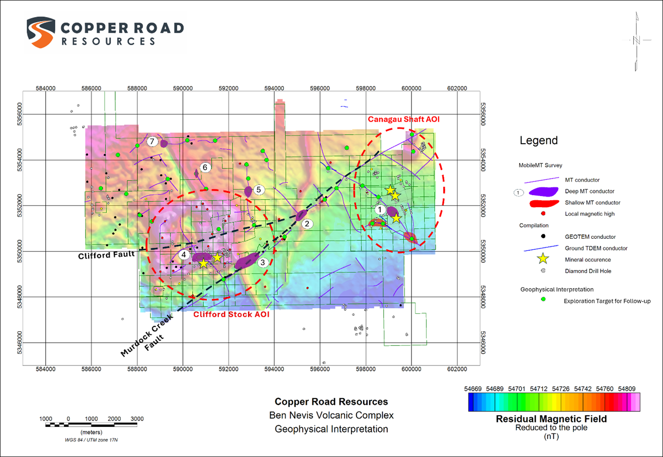
Figure 3: Vertical Derivative of Magnetic Field - Reduced to the Pole
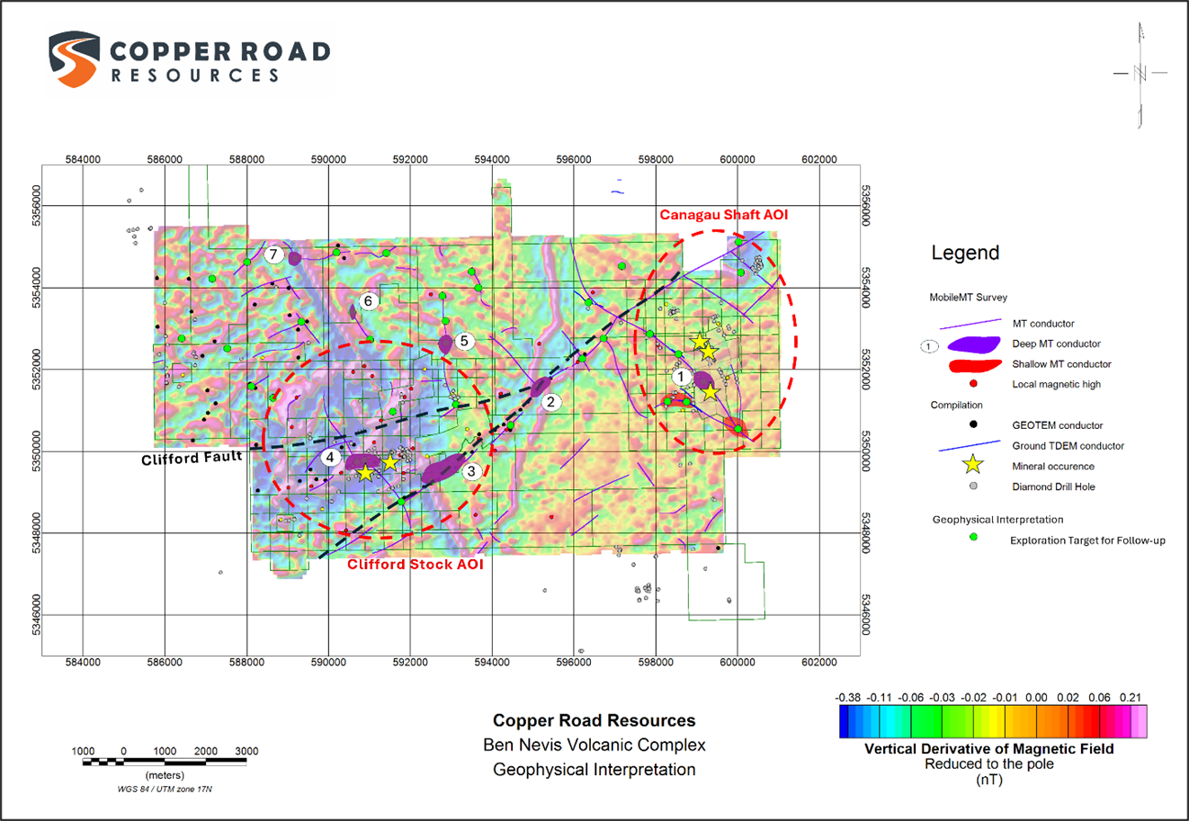
Figure 4: Conductance - Depth Slice 300 metres
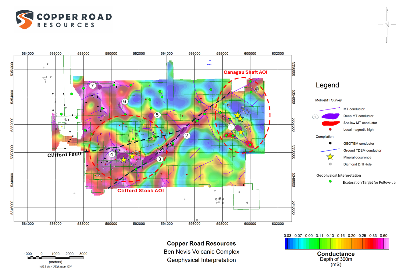
Figure 5: Conductance - Depth Slice 500 metres
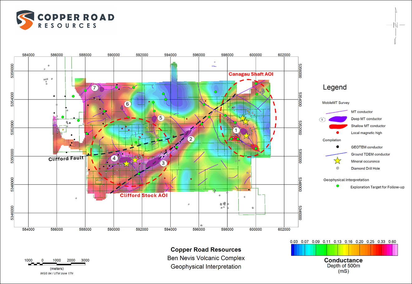
Figure 6: Conductance - Depth Slice 700 metres
Copper Road's Senior Geological Consultant, Mr. Michael Rosatelli, commented: "The MobileMT survey results and geophysical interpretation further highlight the excellent exploration potential of the project. The identification of seven high-priority, deep-seated conductors in areas that have seen only seen shallow testing or no previous exploration points to strong discovery potential for both base metals and gold. Most notably, the depth penetration of the MobileMT system, together with 3D inversion and modelling, has delineated previously unrecognized conductive targets that are now being advanced for follow-up work and drill testing this fall as part of the Company's maiden drill program."
2026 Exploration Program Outline
Phase I: Data Interpretations and Property Compilation
Complete additional detailed analysis of seven (7) deep-seated MobileMT conductors with the objective to define targets of drill testing;
Conduct detailed ground gravity surveys as a second vector for drillhole targeting, over the seven (7) deep-seated MobileMT conductors, and other selected high-priority areas on the property, outlined by previous drilling and prospective geological attributes. The higher resolution of the ground survey will increase the reliability on the position of the planned drillholes, better define the geometry of the conductor and provide the confirmation that a conductive target is dense and possibly representing massive sulphide mineralization for the prioritization of the targets for drill testing;
The geophysical compilation also identified several historical surface induced polarization surveys over both the Canagau and Clifford Stock AOI's. Complete reprocessing and interpretation of the legacy geophysical datasets. The objective is to define targets for drill testing;
Complete diamond drillhole compilation (on-going) for integration into the legacy geophysical reprocessing and interpretation.]; and
On-going scanning, and digitization of historical paper reports, maps etc. incorporated into the geophysical and diamond drill hole database.
Aboriginal Consultation: Separate Exploration Agreement ("EA") discussions with the two primary affected First Nation communities are ongoing.
Phase II: Initiating fieldwork activities for summer field season underway
Property-wide LiDAR survey - to commence in next few weeks depending on weather conditions;
Geological mapping, prospecting and sampling - Follow-up on targets defined by the geophysical interpretations, site investigations of the previously identified mineralized showings, unexplored felsic volcanic horizons, and the Murdoch Creek and Clifford faults -late May-June start-up;
Historical diamond drillhole locations - Field verification process to be conducted in conjunction with the compilation; and
Finalize and submit Exploration Plans and Permit applications, based on the completed and ongoing Phase I and II results, for line cutting, ground geophysical surveys, stripping, and diamond drilling activities.
Phase III: Maiden 6,000 metre diamond drill program on track for the fourth quarter 2026
Once the drill targeting has been completed, the company intends to drill high priority targets.
Property Background
Metallogenic Ore Deposit Model and the Exploration Discovery Potential Rationale - Why explore the Ben Nevis Volcanic Complex
The BNVC is located within the upper Blake River Group ("BRG"). It is the youngest volcanic sequence within the metal endowed Abitibi greenstone belt. Of all the Archean sequences in the Abitibi greenstone belt, the BRG contains the most abundant concentration of volcanogenic massive sulphide ("VMS") deposits.
Approximately half of the total VMS tonnage of the Abitibi greenstone belt is hosted in the BRG, and about 90% of the total Cu-Zn-Ag-Au in the belt is found in the BRG. The Noranda VMS mining district is located approximately 40 kilometres to the east of the BNVC in Quebec, hosts 23 distinct VMS deposits. The Doyon-Bousquet-Laronde camp further to the east, hosts 11 VMS deposits within the Upper BRG rocks1.
The Company believes that the BNVC has the potential to host two (2) separate styles of economic mineralization.
Gold-rich Cu-Zn-Ag-Au VMS mineralization - East Sector of Property: Presence of VMS-style alteration and mineralization indicating that a synvolcanic hydrothermal system existed (i.e. Canagau Shaft). These characteristics are comparable to those in the in the Noranda and Doyon-Bousquet-LaRonde mining camps3,4, located to the east within the same BRG assemblage of rocks3,4.
Archean Porphyry Cu-Au-Mo mineralized system - West sector of property. Historical documented mineral occurrences (i.e. Croxall Breccia) are related to the Clifford Stock in Clifford Township5. The described geological setting and mineralogical attributes suggest a similar analogy to that of the Cote Lake Gold deposit currently in production.
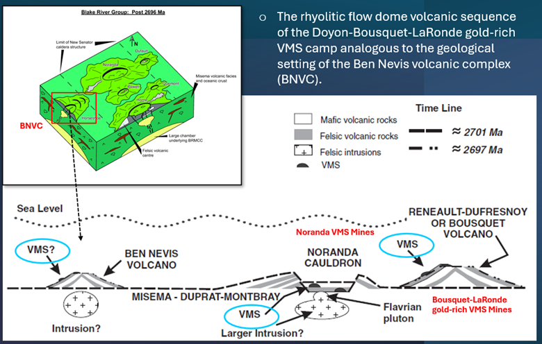
Figure 7: Schematic of the Ben Nevis Volcanic Complex in analogy to the Noranda VMS camp and Laronde-Bousquet-Doyon VMS camp.
Underpinning the geology of the project area is a domal anticlinal package of mafic and felsic volcanic rocks wrapped around the Clifford Stock. Northeast and northwest synvolcanic structures are excellent targets for Noranda-type VMS deposits2. The layered mafic-rhyolitic volcanic package reflects a flow dome complex that hosts the Doyon-Bousquet LaRonde gold-rich VMS deposits.
Qualified Person
Michael P. Rosatelli, M.Sc., P.Geo. the senior geological consultant for the Company, is a Qualified Person, in accordance with the Canadian regulatory requirements as set out in National Instrument 43-101, has reviewed and approved the scientific and technical information that forms the basis for the disclosure contained in this news release.
References
P. Mercier-Langevin, J. Goutier, P.-S. Ross, V. McNicoll, T. Monecke, C. Dion, B. Dubé, P. Thurston, V. Bécu, H. Gibson, M. Hannington, and A. Galley. 2011. The Blake River Group of the Abitibi Greenstone Belt and Its Unique VMS and Gold-Rich VMS Endowment, Geological Survey of Canada, Open File 6869, 72 p.
Jensen, L.S., 1975. Geology of the Clifford and Ben Nevis Townships, District of Cochrane, Geoscience Report 132.
Moore, L.N., Daigneault, R., Aird, H.M., Banerjee, N.R. and Mueller, W.U., 2015. Reconstruction and evolution of Archean intracaldera facies: the Rouyn-Pelletier Caldera Complex of the Blake River Group, Abitibi greenstone belt, Canada. Canadian Journal of Earth Sciences.
Peloquin, A.S., Piercey, J. and Hamilton M.A., 2008. The Ben Nevis Volcanic Complex, Ontario, Canada: Part of the Late Volcanic Phase of the Blake River Group, Abitibi Subprovince. Economic Geology, v. 103 pp 1219-124.
Chaloux, E.C., 2005. The Croxall Breccia Pipe: Geological and Geochemical Study of an Archean Porphyry Cu-Mo-Au System, A project report submitted in partial fulfilment of the requirements for the degree of Applied MSc in Geology, Laurentian University, Department of Earth Sciences, Laurentian University December 2005
For more information, please contact:
Brian Howlett, CPA
President and CEO
Copper Road Resources Inc.
brian@copperroadresources.ca
1-647-227-3035
Caution Regarding Forward-Looking Information
This news release contains forward-looking information that involves substantial known and unknown risks and uncertainties, most of which are beyond the control of Copper Road. Forward-looking statements include estimates and statements that describe Copper Road Resource's future plans, objectives or goals, including words to the effect that Copper Road Resources or its management expects a stated condition or result to occur. Forward-looking statements may be identified by such terms as "believes", "anticipates", "expects", "estimates", "may", "could", "would", "will", or "plan". Since forward-looking statements are based on assumptions and address future events and conditions, by their very nature they involve inherent risks and uncertainties. Although these statements are based on information currently available to Copper Road Resources, the Company provides no assurance that actual results will meet management's expectations. Risks, uncertainties and other factors involved with forward-looking information could cause actual events, results, performance, prospects and opportunities to differ materially from those expressed or implied by such forward-looking information. Forward looking information in this news release includes, but is not limited to, the Company's objectives, goals or future plans, statements, details of the exploration results, potential mineralization, Copper Road Resource's treasury, management team and enhanced capital markets profile, the estimation of mineral resources, exploration and mine development plans, timing of the commencement of operations and estimates of market conditions. Factors that could cause actual results to differ materially from such forward-looking information include, but are not limited to, failure or inability to complete the Offering on disclosed terms or at all, regulatory approval processes, failure to identify mineral resources, delays in obtaining or failures to obtain required governmental, regulatory, environmental or other project approvals, political risks, inability to fulfill the duty to accommodate First Nations and other indigenous peoples, uncertainties relating to the availability and costs of financing needed in the future, changes in equity markets, inflation, changes in exchange rates, fluctuations in commodity prices, delays in the development of projects, capital and operating costs varying significantly from estimates and the other risks involved in the mineral exploration and development industry, and those risks set out in the Company's public documents filed on SEDAR. Although the Company believes that the assumptions and factors used in preparing the forward-looking information in this news release are reasonable, undue reliance should not be placed on such information, which only applies as of the date of this news release, and no assurance can be given that such events will occur in the disclosed time frames or at all. Copper Road Resources disclaims any intention or obligation to update or revise any forward-looking information, whether as a result of new information, future events or otherwise, other than as required by law. Neither the TSXV nor its Regulation Services Provider (as that term is defined in the policies of the TSXV) accepts responsibility for the adequacy or accuracy of this news release.
SOURCE: Copper Road Resources Inc.
View the original press release on ACCESS Newswire:
https://www.accessnewswire.com/newsroom/en/metals-and-mining/copper-road-ben-nevis-volcanic-complex-property-1170772
