
Toronto, Ontario--(Newsfile Corp. - July 29, 2026) - Canuc Resources Corporation (TSXV: CDA) (OTCQB: CNUCF) (WKN: A41V6H) ("Canuc" or the "Company") is pleased to provide an update for the Company's East Sudbury Project ("ESP"). ESP spans 20,078 hectares and is centered approximately 20 kilometers NE of the Sudbury Mining District (Figure 1 - ESP Regional Map).
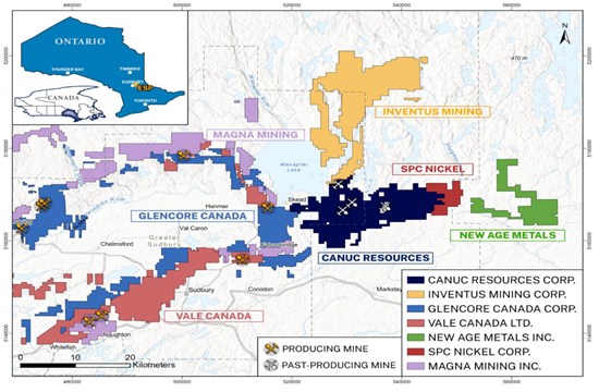
Figure 1 - East Sudbury Project (ESP) Regional Map
To view an enhanced version of this graphic, please visit:
https://images.newsfilecorp.com/files/2906/306916_466053bbd4279aa5_001full.jpg
Innovative 3-D Seismic Survey
OptiSeis Solutions Ltd. ("OptiSeis" or the "Company") is proud to announce the successful completion of an innovative mineral exploration seismic survey along the northern section of the McLaren Lake Fault Zone on Canuc's East Sudbury Project located within the Greater Sudbury Region of Ontario, Canada - one of the world's premier and most storied mining districts. The seismic survey completed by OptiSeis has delivered a rich, high-quality subsurface dataset that will now be used for targeting large-scale, regional mineral potential along the McLaren Lake Fault Zone (Figure 2 - ESP Fault Structures & Area of Survey).
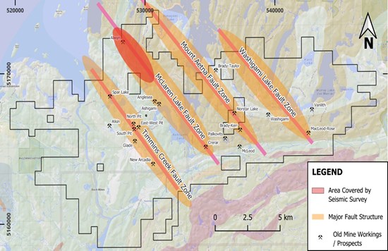
Figure 2 - ESP Fault Structures & Area of Survey
To view an enhanced version of this graphic, please visit:
https://images.newsfilecorp.com/files/2906/306916_466053bbd4279aa5_002full.jpg
Survey Precision & Efficiency
The seismic survey program covered approximately 13.5 kilometers of total line length - with every meter of seismic acquisition conducted along existing roadways to minimize environmental disturbance and community impact. Field operations were completed in just seven days and executed safely and without a single incident, a testament to the OptiSeis' disciplined, safety-first approach to field execution.
Next-Generation, Low-Impact Technology
The survey showcased a modern acquisition design built around 1,355 autonomous nodal sensors deployed across the project area. Seismic energy was generated by an array of two IVI Minivibrators - a controlled, environmentally responsible energy source - and over the course of the program more than 2,700 seismic source points were recorded into the ground sensor array, generating a dense and detailed picture of the subsurface.
A Standout Scientific Collaboration
In conjunction with the surface program, a Vertical Seismic Profile (VSP) was acquired by Natural Resources Canada (NRCan). The VSP recorded seismic energy on fibre-optic cable installed within three centrally located wellbores - a unique opportunity to capture complementary datasets that may enhance subsurface characterization and contribute to ongoing geoscience research. This collaboration underscores the growing role of advanced, technology-driven methods in responsible resource exploration.
Field acquisition services were provided by Echo Seismic Ltd., a respected Calgary-based geophysical contractor selected for the project. A focused workforce of 11 personnel supported field operations, including two representatives from OptiSeis, with an additional two NRCan personnel onsite to support the VSP acquisition.
"This project demonstrates how modern seismic technology can support mineral exploration objectives while maintaining a very small surface footprint,"
"By combining autonomous modal sensors, low-impact vibrator energy sources, and existing roadway infrastructure, we were able to safely acquire high-quality subsurface imaging data while minimizing impacts on the local environment and surrounding community." Andrea Cook, Chief Executive Officer, OptiSeis Solutions Ltd.
Throughout the program, professional traffic control services were employed to support safe operations and minimize disruption to local residents. This operational practice reflects an OptiSeis commitment to being a responsible and respectful partner in the communities where it works.
3 Pictures of Seismic Survey in Progress
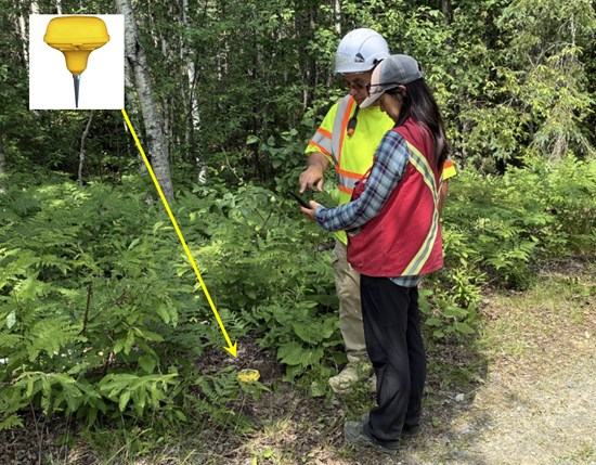
Picture 1: The compact autonomous nodes are deployed along the road edge, and ground crew utilize Bluetooth communication with the node to perform a QC check.
To view an enhanced version of this graphic, please visit:
https://images.newsfilecorp.com/files/2906/306916_466053bbd4279aa5_003full.jpg
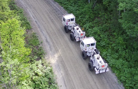
Picture 2: The Vibroseis units work as a pair, emitting signal into the ground which is recorded by the ground sensors.
To view an enhanced version of this graphic, please visit:
https://images.newsfilecorp.com/files/2906/306916_466053bbd4279aa5_004full.jpg
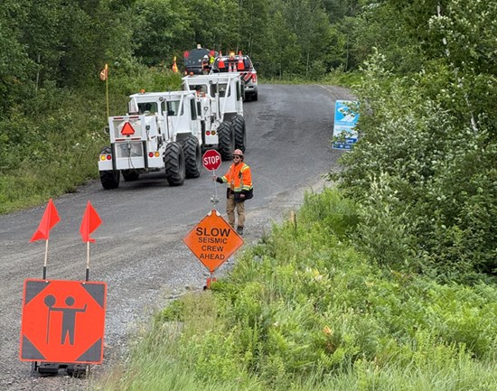
Picture 3: Traffic control along the public roadways ensured safe operations and minimized disruptions for local traffic.
To view an enhanced version of this graphic, please visit:
https://images.newsfilecorp.com/files/2906/306916_466053bbd4279aa5_005full.jpg
Program Objectives
"This innovative 3-D seismic survey, which has been undertaken by industry leading geotechnical professionals at OptiSeis Solutions Ltd. under the auspices, and with the support. of Natural Resources Canada, is expected to result in direct actionable exploration targets for prospective MIAC and IOCG deposit types which may be identified proximal to the historical copper and gold mine workings along the McLaren Lake Fault Zone on Canuc's 100% owned East Sudbury Project," stated Christopher Berlet, President and CEO of Canuc.
"We will follow up promptly on the targets that result from this work, and also on those that result from our upcoming property-wide gravity gradiometric survey which covers all four (4) of the fault structures that transect the ESP property, in pursuit of a transformational regional exploration outcome."
The technical and scientific information in this press release has been reviewed and approved by Seymour Sears, B.A., B.Sc., P.Geo, a non-independent qualified person as defined by NI 43-101, who is currently managing exploration activity on the ESP Project.
About Canuc Resources Corporation
Canuc Resources Corporation is a junior resource company developing its 100% interest in the East Sudbury Project ("ESP") which spans 20,078 hectares and is centered approximately 20 kilometers northeast of the Prolific Sudbury Mining Camp and near to the extensive infrastructure of the adjacent Sudbury Mining District. ESP encompasses several centers of critical and precious metal mineralization interpreted to be related to a mineral system that can form IOCG and affiliated critical and precious mineral deposits. Included within the Project is the historical Scadding Gold Mine and associated Scadding Gold Tailings Project.
Canuc also holds a 100% interest in the San Javier Silver-Gold Project located in Sonora State, Mexico. The San Javier Silver-Gold Project spans 28 claims covering 1,052 hectares and evidences extensive silver, gold and copper mineralization interpreted to be related to a mineral system that can form silver-dominant IOCG and affiliated deposits.
Canuc generates cash flow from natural gas production at its MidTex Energy Project located in Central West Texas, USA where Canuc has an interest in eight (8) producing natural gas wells and has rights for further in field developments. The Company also receives a 4% Net Smelter Royalty from gold production at the Scadding Gold Tailings Project located on Mining Claim LEA 107735 within the ESP property group.
For further information please refer to the Company website: www.canucresources.ca
Christopher J. Berlet B.A.Sc.(Mining), CFA, CEO & Director of Canuc, is responsible for the content of this press release.
For further information please contact:
Canuc Resources Corporation
(416) 525 - 6869
cberlet@canucresources.ca
Forward Looking Information
This news release contains forward-looking information. All information, other than information of historical fact, constitute "forward-looking statements" and includes any information that addresses activities, events or developments that the Corporation believes, expects or anticipates will or may occur in the future including the Corporation's strategy, plans or future financial or operating performance.
When used in this news release, the words "estimate", "project", "anticipate", "expect", "intend", "believe", "hope", "may" and similar expressions, as well as "will", "shall" and other indications of future tense, are intended to identify forward-looking information. The forward-looking information is based on current expectations and applies only as of the date on which they were made. The factors that could cause actual results to differ materially from those indicated in such forward-looking information include, but are not limited to, the ability of the Corporation to fund the exploration expenditures required under the Agreement. Other factors such as uncertainties regarding government regulations could also affect the results. Other risks may be set out in the Corporation's annual financial statements, MD&A and other publicly filed documents.
The Corporation cautions that there can be no assurance that forward-looking information will prove to be accurate, as actual results and future events could differ materially from those anticipated in such information. Accordingly, investors should not place undue reliance on forward-looking information. Except as required by law, the Corporation does not assume any obligation to release publicly any revisions to forward-looking information contained in this press release to reflect events or circumstances after the date hereof.
Neither the TSXV nor its Regulation Services Provider (as that term is defined in the policies of the TSXV) accepts responsibility for the adequacy or accuracy of this news release.

To view the source version of this press release, please visit https://www.newsfilecorp.com/release/306916
Source: Canuc Resources Corporation

