

VANCOUVER, BC / ACCESS Newswire / August 28, 2025 / Kingfisher Metals Corp. (TSXV:KFR)(FSE:970)(OTCQB:KGFMF) ("Kingfisher" or the "Company") is pleased to provide an update on the 2025 exploration program at the HWY 37 Project. The 849 km2 HWY 37 Project is located within the Golden Triangle, British Columbia.
Drilling to date has focused on testing for depth extensions of the Williams porphyry Cu-Au system, porphyry Cu-Au targets across the valley (east) in areas with no historical drilling, and at the Upper and Lower Hank porphyry Cu-Au targets (Figures 1, 2 and Table 1).
Summary of Work Completed to date:
6,850 meters of drilling
HW-25-001, -002, -003, -004, and -006 have been sent to the Bureau Vertitas lab for assay (currently logging the remainder)
84 person days of mapping
>750 soil samples
>650 surface rocks samples
30.7 line-km of IP geophysics
1,750 line-km (covering ~319 km2) of airborne Mobile Magneto Tellurics (MMT) geophysical survey
Light Detection and Ranging (LiDAR) survey covering 256 km2
The exploration team is busy compiling and interpreting all the information that has been collected this season.
Dustin Perry, CEO, states "We continue to see our exploration hypothesis validated with visible copper mineralization directly below known grade at Williams. HW-25-006 at Upper Hank intersected an 800-m vertically extensive sulfide-bearing hydrothermal system, confirming our hypothesis that the multi-kilometer scale hydrothermal system at Hank extends significantly at depth. In addition to drilling, our exploration team and consultants have covered a broad area with multiple geological, geophysical, and geochemical programs that will serve to further unlock the potential of this highly prospective large project."
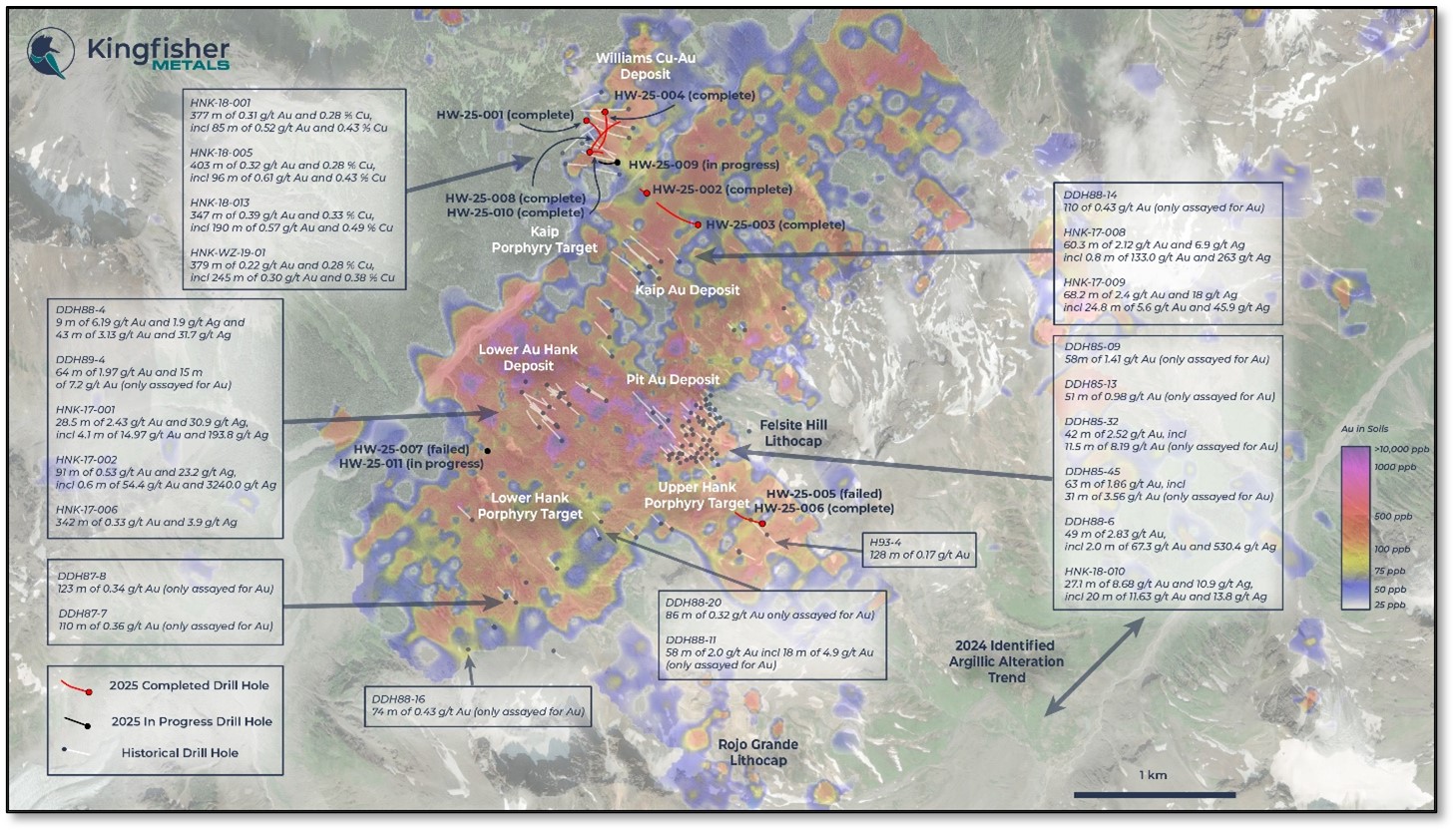
Figure 1: Hank-Williams Drill Area
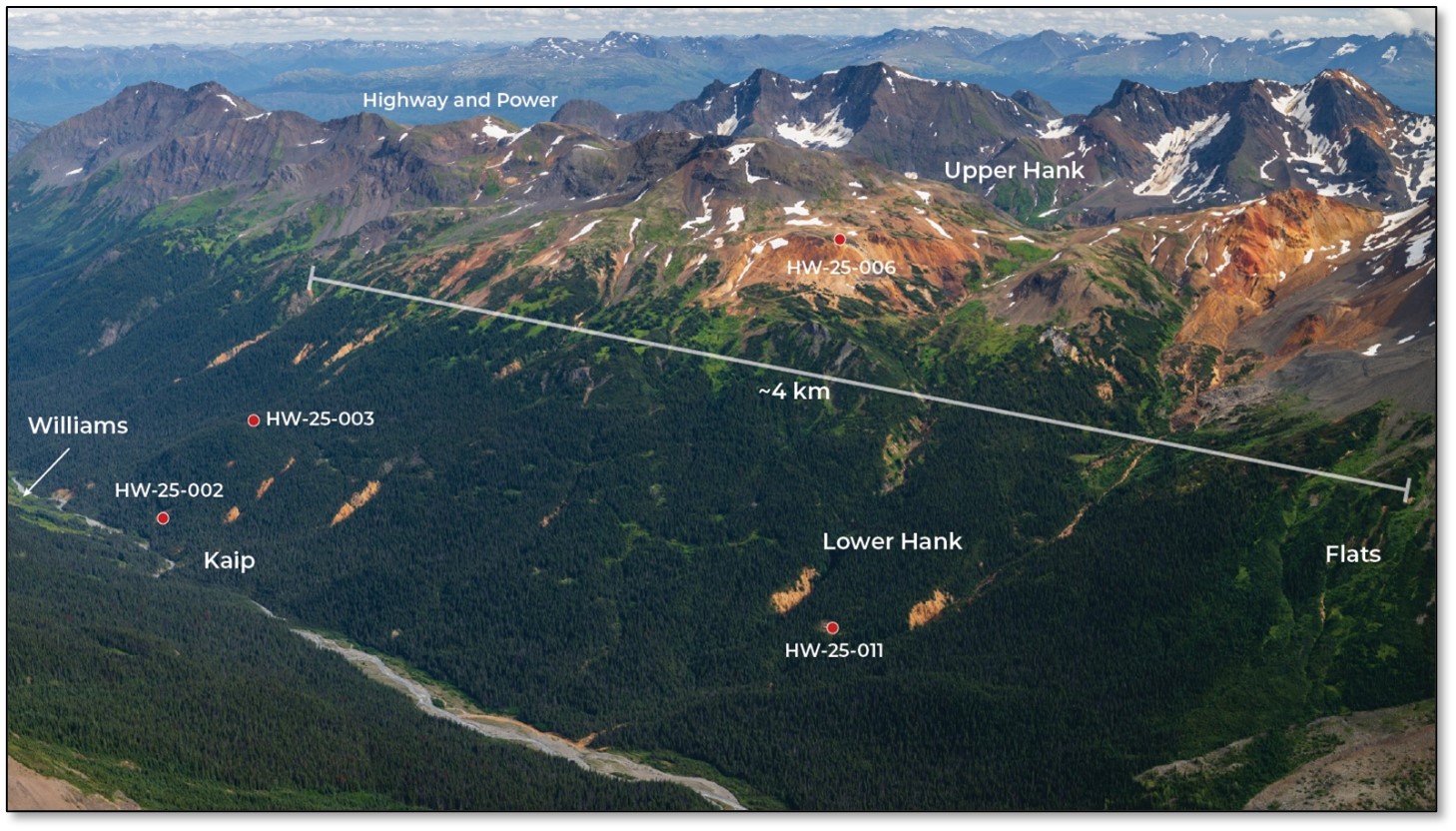
Figure 2: Hank-Williams Alteration System
Hole ID | Zone | Easting | North | Azi | Dip | Final Depth | Status |
|---|---|---|---|---|---|---|---|
UTM NAD83 Zone 09 | |||||||
HW-25-001 | Williams | 409395 | 6344077 | 110 | -80 | 803 | Complete, samples shipped to assay lab |
HW-25-002 | East Williams | 409769 | 6343628 | 292 | -85 | 550 | Complete, samples shipped to assay lab |
HW-25-003 | East Williams | 410086 | 6343432 | 286 | -68 | 668 | Complete, samples shipped to assay lab |
HW-25-004 | Williams | 409510 | 6344131 | 169 | -75 | 886 | Complete, samples shipped to assay lab |
HW-25-005 | Upper Hank | 410475 | 6341586 | 295 | -76 | 282 | Lost hole at 282m well short of proposed depth - challenging ground conditions |
HW-25-006 | Upper Hank | 410475 | 6341586 | 295 | -77 | 839 | Complete, samples shipped to assay lab. Redrill of HW-25-005 |
HW-25-007 | Lower Hank | 408783 | 6342029 | 110 | -65 | 192 | Lost hole at 192 m well short of proposed depth - equipment issues |
HW-25-008 | Williams | 409415 | 6343882 | 27 | -73 | 893 | Complete, detail logging and sampling in progress |
HW-25-009 | Williams | 409586 | 6343820 | 254 | -82 | In progress | In progress |
HW-25-010 | Williams | 409419 | 6343879 | 75 | -85 | 797 | Complete, detail logging and sampling in progress |
HW-25-011 | Lower Hank | 408790 | 6342030 | 110 | -65 | In progress | In progress, Redrill of HW-25-007 |
Table 1: Summary of drill program status
Williams Area Drilling
At the time of writing, four diamond drill holes have been completed (3,375 m) within the Williams mineralized system, with one in progress. The initial two holes completed at Williams, HW-25-001 and HW-25-004 were previously discussed in a news release on July 31st. Since that time, HW-25-008 and HW-25-010 have been completed to a total depth of 893 m and 797 m respectively. HW-25-009 is currently in progress and is proposed to a final depth of 750 m (see Figure 1). The purpose of the drill holes HW-25-008, -009, and -010 are to delineate the deep-level geometry of the Williams porphyry system.
HW-25-008
This hole was designed to cross quartz stockwork veins with chalcopyrite +/- bornite mineralization observed at surface, and test the strike and depth extent of the Williams porphyry to the northeast. Hole HW-25-008 has several intercepts (Figures 3, 4, 5) of both early and syn-mineral monzonite porphyry with higher copper mineralized intervals with bornite within and at flank of the syn-mineral porphyry.
Summary:
0-157 m: potassic alteration with varying amounts of chalcopyrite ± bornite
157-253 m: felsic stratigraphy with low sulfide and trace chalcopyrite concentrations
253-810 m: potassic alteration in mixed monzonite and wall rock with variable chalcopyrite ± bornite
810-893 m: flanking alteration of epidote-magnetite-K-feldspar, low relative chalcopyrite and increase in pyrite
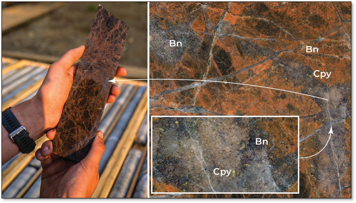
Figure 3: HW-25-008 - 315 m (Bn = Bornite, Cpy = Chalcopyrite)1
Potassic alteration with copper sulfide mineralization
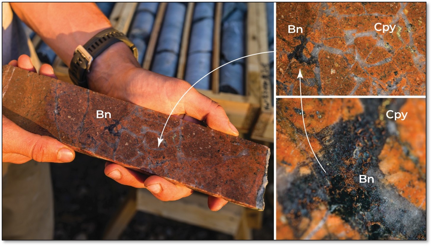
Figure 4: HW-25-008 - 324 m (Bn = Bornite, Cpy = Chalcopyrite)1
Potassic alteration with copper sulfide mineralization
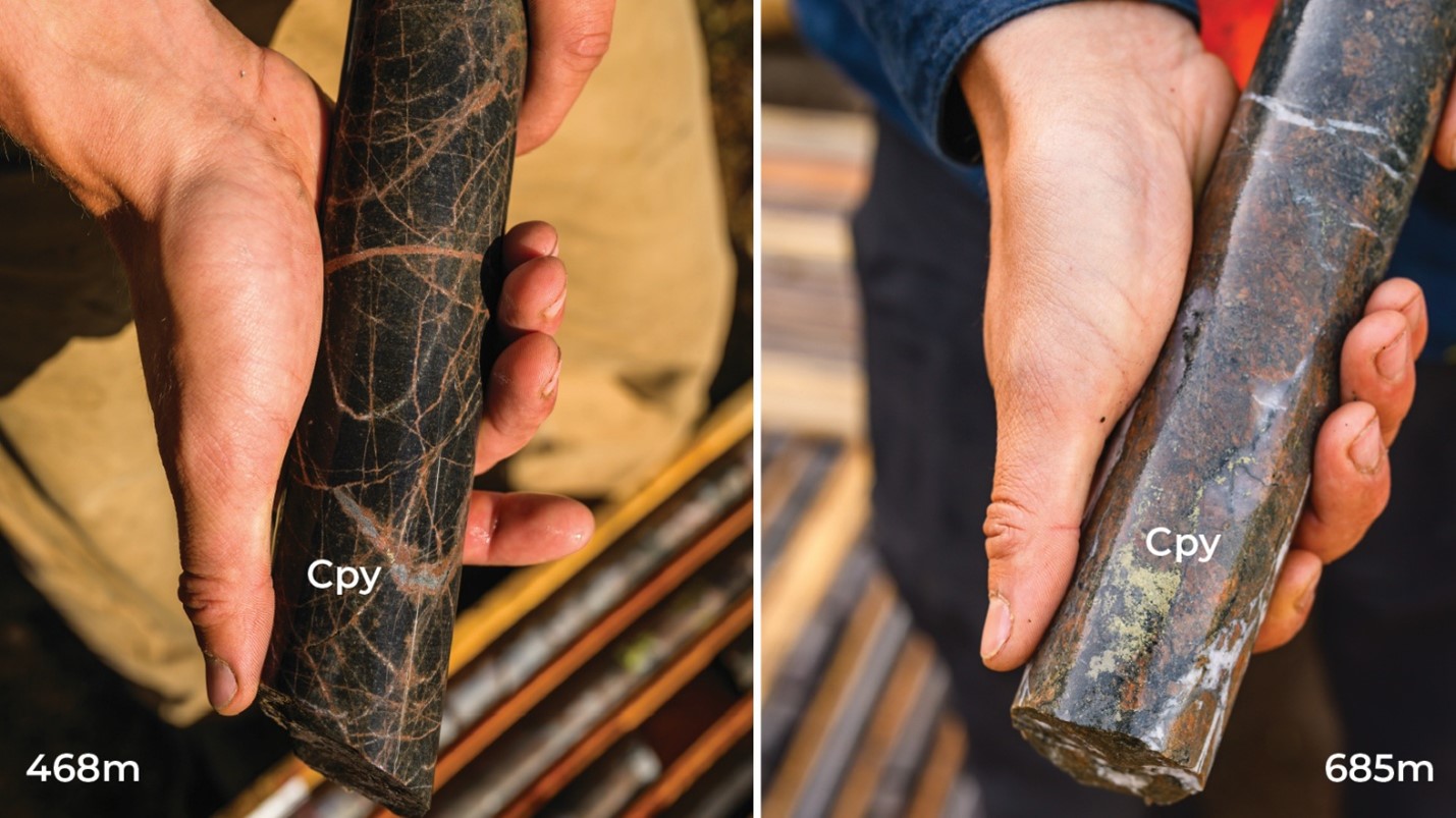
Figure 5: HW-25-008 - 468 m and 685 m (Cpy = Chalcopyrite)1
Potassic alteration with copper sulfide mineralization
HW-25-009
Hole HW-25-009 collared in the SW Williams deposit with azimuth of 260o and dip of -82o. It is designed to cross and characterize the deeper extents of the porphyry alteration below historical hole HNK-18-002. At the time of writing, this hole is in progress.
HW-25-010
Hole HW-25-010 collars uphill of HW-25-009 on same drill pad as HW-25-008 with azimuth of 075º and dip of -85º. Similar to hole HW-25-009, the hole is designed to test the deeper domain boundaries of the porphyry system. Hole HW-25-010 accomplished this goal and defined the eastern boundary of the porphyry alteration system. The hole is recently shut down and detailed geological logging is underway.
Summary:
0-196.5 m: potassic alteration with varying amounts of chalcopyrite +/- bornite in wall rock
196.5-268 m: felsic host rock less favourable host, low relative chalcopyrite abundance
268-521 m: variable potassic alteration in mixed monzonite and wall rock with chalcopyrite +/- bornite
521-797 m: wall rock overprinted by porphyry flanking-type alteration (K-feldspar-epidote-magnetite-chlorite) and low relative chalcopyrite
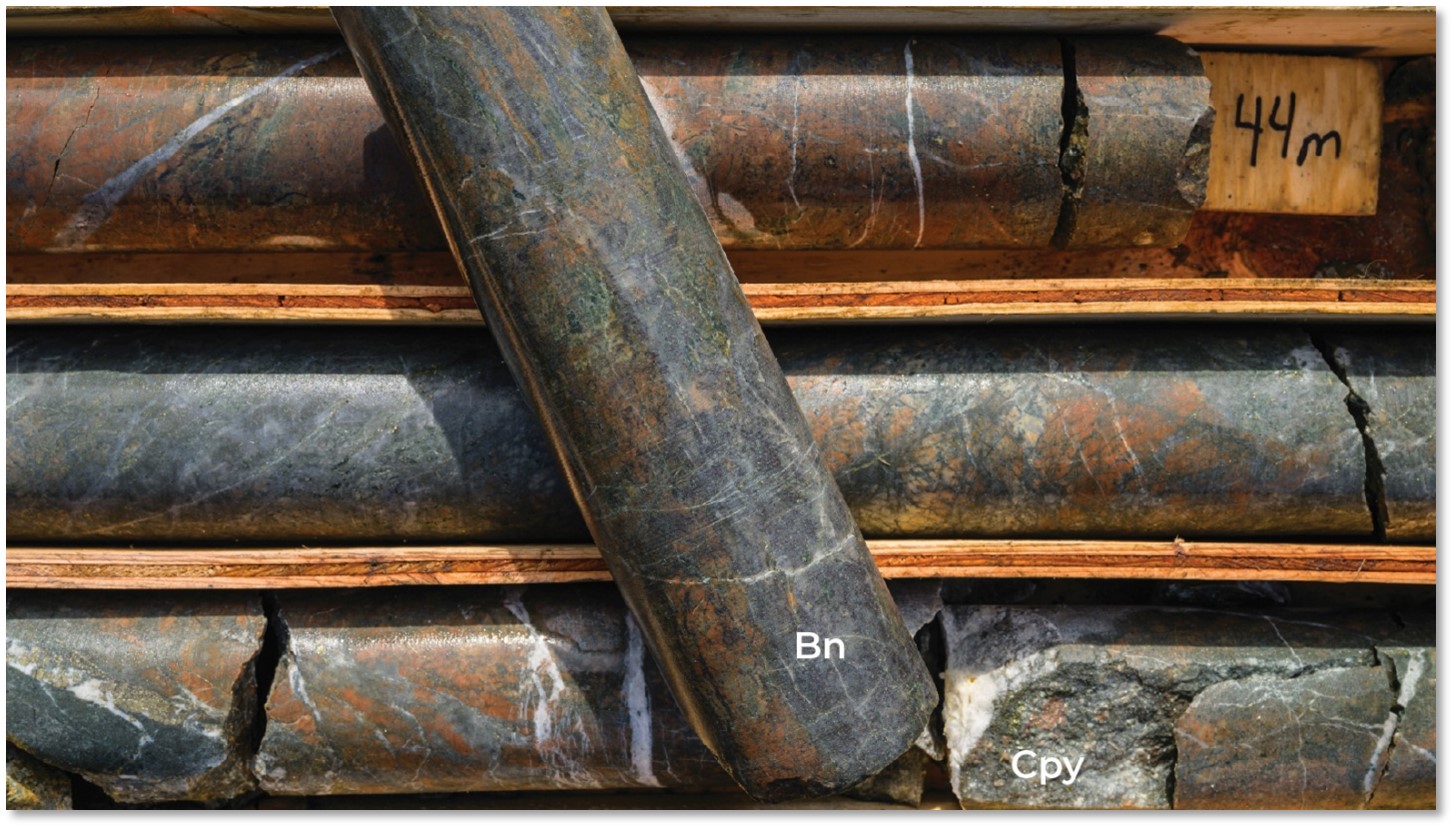
Figure 6: HW-25-010 - 44.8 m (Bn = Bornite, Cpy = Chalcopyrite)1
Potassic alteration with copper sulfide mineralization
Upper Hank Drilling
Hole HW-25-006 was collared at 295o azimuth and -78o dip and targeted a chargeability anomaly at Upper Hank. The hole follows an initial attempt with HW-25-005, which was lost at 281 m depth due to challenging ground conditions.
Preliminary Summary of HW-25-006:
The data and observations are currently being compiled and interpreted. Once final assay results are received, we will concentrate on final interpretations and possible future targeting
This is the first test into the large-scale lithocap observed on the project
Drilled to a total depth of 842 m
Vertically zoned system from upper chalcedonic silica-pyrite to deeper-level biotite-quartz-pyrite
Collared into a previously mapped pyrite-rich breccia body at surface
The drill continued through zones of variable concentrations of sooty pyrite cement breccias (pyrite 5-10%) and fine pyrite stringers within basalt until end of hole at 842 m
The pyrite-rich breccia units are accompanied by local zones of trace base metal sulfides that include molybdenite, sphalerite, chalcopyrite, arsenopyrite and galena
This widespread pyrite alteration and veins significantly extends the historically mapped and drilled hydrothermal system to depth
At this time, the hydrothermal alteration observed at Upper Hank is not interpreted to be porphyry in character and interpretation is ongoing
The amount of pyrite intercepted in the drill hole explains the IP chargeability anomaly
These results suggest that the Upper Hank chargeability anomaly has the potential for future targeting of both porphyry and precious metal mineralized systems but, this will have to be validated with receipt of all data and assays
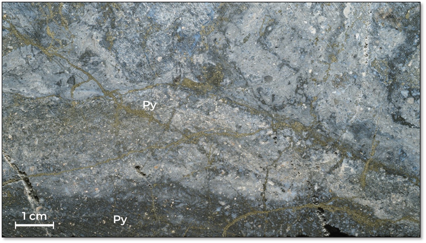
Figure 7: HW-25-006 - 53.4 m (Py = Pyrite)1
Characteristic brassy fine pyrite and dark disseminated sooty pyrite (photo bottom)
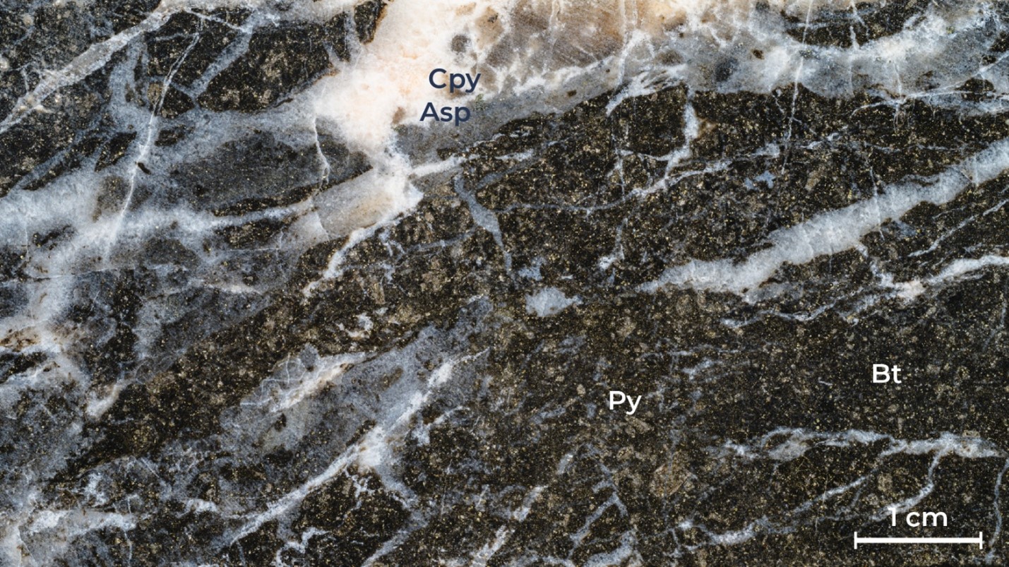
Figure 8: HW-25-006 - 763 m (Py = Pyrite, Cpy = Chalcopyrite, Asp = Arsenopyrite, Bt = Biotite)1
Biotite altered quartz-carbonate vein breccia with fine grained disseminated pyrite and trace vein-hosted chalcopyrite and arsenopyrite
Lower Hank Drilling
Hole HW-25-011 is currently drilling at the Lower Hank Porphyry Target with a collar azimuth of 174o and a dip of -65o. This is a re-drill hole HW-25-007, which was lost to equipment issues at 192 m. The hole is projected to intersect a steep quartz-sericite-pyrite-carbonate structure mapped on surface (>5% Py) at 200 m drill hole depth. The projection of the low-angle plunge of Au-Ag mineralization in the historical LAZ drill holes projects to ~200-250 m depths of the planned hole. Below 250 m, the hole is projected to pass into the chargeability anomaly (> 25 mv/V) and will test for a porphyry body at a comparable elevation to the Williams deposit.
Regional Exploration Update
The airborne electromagnetic (MMT) survey is complete covering an area of 319 km2. Induced polarization (IP) geophysics is also complete with a total of 30.7 line-kilometer surveyed. Additionally, a Light Detection and Ranging (LiDAR) survey covering 256 km2 over the Hank-Williams-Mary area has been completed to further assist with structural modeling.
A large surface mapping campaign was conducted by Dr. Stephanie Sykora focused on Williams-Hank area and Dr. Roy Greig with a team of mapping geologists from C.J. Greig & Associates focusing on regional geology and targeting. A total of 84 person days of field mapping are complete.
[1] Examples of drill core photos are included to show the different styles of lithology, alteration, and mineralization, and are not necessarily representative of the entire lengths of specific intervals discussed within this release.
Qualified Person
Dustin Perry P.Geo., Kingfisher's CEO, is the Company's Qualified Person as defined by National Instrument 43-101, Standards of Disclosure for Mineral Projects, and has prepared the technical information presented in this release.
About Kingfisher Metals Corp.
Kingfisher Metals Corp. (https://kingfishermetals.com/) is a Canadian based exploration company focused on copper-gold exploration in the Golden Triangle, British Columbia. Through outright purchases and option earn in agreements (Orogen Royalties and Golden Ridge Resources) the Company has quickly consolidated one of the largest land positions in the region at the contiguous 849 km2 HWY 37 Project. Kingfisher also owns (100%) two district-scale orogenic gold projects in British Columbia that total 641 km2. The Company currently has 88,661,810 shares outstanding.
For further information, please contact:
Dustin Perry, P.Geo.
CEO and Director
Phone: +1 778 606 2507
E-Mail: info@kingfishermetals.com
Neither the TSX-V nor its Regulation Services Provider (as that term is defined in the policies of the TSX-V) accepts responsibility for the adequacy or accuracy of this release.
Cautionary Note Regarding Forward-Looking Statements
Mineralization hosted on adjacent and/or nearby properties is not necessarily indicative of mineralization hosted on the Company's property. This news release contains statements that constitute "forward-looking statements." Such forward-looking statements involve known and unknown risks, uncertainties and other factors that may cause the Company's actual results, performance or achievements, or developments to differ materially from the anticipated results, performance or achievements expressed or implied by such forward-looking statements. Forward-looking statements are statements that are not historical facts and are generally, but not always, identified by the words "expects," "plans," "anticipates," "believes," "intends," "estimates," "projects," "potential" and similar expressions, or that events or conditions "will," "would," "may," "could" or "should" occur.
Forward-looking statements in this news release include, among others, statements relating to expectations regarding the projects, and other statements that are not historical facts. By their nature, forward-looking statements involve known and unknown risks, uncertainties and other factors which may cause our actual results, performance or achievements, or other future events, to be materially different from any future results, performance or achievements expressed or implied by such forward-looking statements. Such factors and risks include, among others: the Company may require additional financing from time to time in order to continue its operations which may not be available when needed or on acceptable terms and conditions acceptable; compliance with extensive government regulation; domestic and foreign laws and regulations could adversely affect the Company's business and results of operations; the stock markets have experienced volatility that often has been unrelated to the performance of companies and these fluctuations may adversely affect the price of the Company's securities, regardless of its operating performance.
The forward-looking information contained in this news release represents the expectations of the Company as of the date of this news release and, accordingly, is subject to change after such date. Readers should not place undue importance on forward-looking information and should not rely upon this information as of any other date. The Company undertakes no obligation to update these forward-looking statements in the event that management's beliefs, estimates or opinions, or other factors, should change.
SOURCE: Kingfisher Metals Corp.
View the original press release on ACCESS Newswire:
https://www.accessnewswire.com/newsroom/en/metals-and-mining/kingfisher-provides-exploration-update-at-hwy-37-project-golden-triangle-1066489
