Vancouver, British Columbia--(Newsfile Corp. - September 3, 2025) - Gold Finder Resources Ltd. (TSXV: GLD) (OTCQB: GLDFF) ("Gold Finder" or the "Company") is a gold explorer focused on the discovery potential of overlooked and underexplored properties. The Company's current properties are all located in northwestern Ontario, home to some of the world's most productive gold belts (Figure 1).
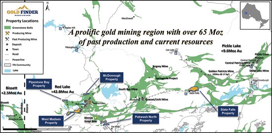
Figure 1: Property Locations within the Archean Greenstone Belts of Northwestern Ontario.
To view an enhanced version of this graphic, please visit:
https://goldfinderresources.com/images/maps/Gold-Finder_Property-Locations.jpg
Current projects include the West Madsen, Pipestone Bay, Pakwash North, and McDonough properties all located in the Red Lake Mining District; and the Slate Falls property located in the Patricia Mining District (Figure 1). An exploration update on each project follows.
West Madsen Property
Results from the summer 2025 prospecting and soil sampling program have now been received and will be released shortly following a review and assessment of the geochemical data.
Gold Finder owns a 100% interest in the West Madsen property, which was originally acquired from Great Bear Resources, and now covers 5,936 hectares in the heart of the Red Lake Gold Camp. West Madsen adjoins the Madsen Mine property (Figure 2) owned by West Red Lake Gold Mines (WRLG). Production at the Madsen Mine restarted in June and, as reported in WRLG's operations update of August 6, 2025, 3,800 ounces of gold were produced in July, and ore processing at the mill is ramping up to the permitted 800 tonnes per day.
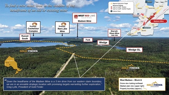
Figure 2: Drone View Looking NE Toward WRLG's Madsen Mine/Mill Complex
To view an enhanced version of this graphic, please visit:
https://goldfinderresources.com/images/westmadsen/WM-BLK-A_WRLG.jpg
Slate Falls Property
The 100 %-owned Slate Falls property is located within the southwestern extension of the Meen-Dempster Greenstone Belt, between the Red Lake and Pickle Lake gold camps. The 5,100-hectare property covers key regional-scale structures that correlate with numerous high-grade gold and silver showings identified over a 10-kilometre trend within the claim package. Previously reported work in 2019 and 2020, targeted east-west shear zones containing high-grade quartz veins where grab samples returned values of up to 331.8 grams per tonne (g/t) gold and 3,025 g/t silver, and follow-up drilling returned values of up to 78.5 g/t gold and 73.7 g/t silver over 0.24 metres.
Subsequent work on the property has included an airborne high-resolution magnetic (MAG) survey and a structural study that incorporated the MAG survey data with all known lithological and mineralogical information and structural measurements. The resulting interpretation highlighted major east-northeast-trending shear zones and fold structures across the property (see structural interpretation map).
The next phase of target development fieldwork will include a fresh look at the high-grade Trail and Sanderson zones. Mapping and sampling will also be carried out on showings in the eastern part of the property, which Gold Finder has never visited, such as the FTM Zone (historical grab samples up to 149 g/t gold and 169 g/t silver) and the Fry Lake #5 Occurrence (3.8 g/t gold and 0.083% uranium oxide).
The Company is actively engaged in discussions with local First Nations regarding an updated Exploration Agreement. Further updates will be provided as they become available.
Pipestone Bay Property
A prospecting program in the western part of the Pipestone Bay Property earlier this summer did not yield any significant gold results from grab samples, with values ranging from <2 to 74 ppb gold. However, several horizons of banded iron formation were identified, which have previously returned anomalous gold values on the property (with a known maximum of 730 ppb gold). Higher-grade values are known to occur along strike to the southeast of the property (e.g. the historical Ledge showings where gold is related to quartz veining near mafic-felsic contact zones and banded iron formation, with values up to 22.1 g/t gold over 0.5 meters in channel samples and 7.7 g/t gold over 0.9m including 30.9 g/t gold over 0.14m in diamond drill core (Singh 2005)). Systematic geological mapping, prospecting and soil sampling is warranted in the western part of the property, followed by backhoe stripping and diamond drilling if warranted.
Meanwhile, the 991 Zone in the eastern part of the property remains a drill-ready target. Only one known drillhole has tested the zone, which is hosted in felsic volcanic rocks at the contact with a folded ultramafic body to the north. The 2004 hole intersected a 200-meter-wide quartz-sericite alteration zone containing anomalous gold and copper values but was drilled parallel to high-grade north-south quartz veins previously identified at the showing, which Gold Finder sampled in 2019, obtaining up to 44.9 g/t gold from grab samples.
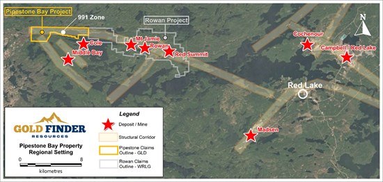
Figure 3: Pipestone Bay Property Regional Setting
To view an enhanced version of this graphic, please visit:
https://goldfinderresources.com/images/Pipestone-Bay/Pipestone-Regional-Setting.jpg
The 100%-owned, 1,015-hectare Pipestone Bay property is located approximately 32 km west of the town of Red Lake and is adjacent to the Rowan Property of West Red Lake Gold Mines (WRLG) (Figure 3). The 991 Zone may represent the western extension of a regional structural corridor on the Rowan property which hosts three past producing gold mines: Mt Jamie, Rowan and Red Summit. WRLG recently carried out a Preliminary Economic Assessment (PEA) for the Rowan Mine, reporting an Indicated resource of 0.197 Moz at 12.78 g/t gold and an Inferred resource of 0.118 Moz at 8.73 g/t gold (Note: the QP has not verified the reported resource estimates and these are not necessarily representative of mineralization present on the Pipestone Bay Property).
Pakwash North Property
Located ~36 km southeast of the town of Red Lake, Gold Finder holds a 40% interest in the 3,105-hectare Pakwash North property with BTU Metals having earned the remaining 60% interest in the property via a March 2021 option agreement. Exploration work by BTU included Time Domain Electromagnetic and Induced Polarization surveys over part of the property and a four-drill hole program that returned low values in copper, zinc, and gold.
The property adjoins the southeastern portion of BTU's Dixie Halo property that was optioned to Kinross Gold in February 2023 and the northern boundary of Kinross's Bruce Lake property (see area claim map). BTU announced on May 20, 2025, that Kinross had commenced a drill program that is planned to include approximately 8,000 metres on various target areas identified as priority locations for potential gold mineralization. Results are expected in early Q4 as reported in BTU's Annual Management's Discussion and Analysis dated August 5, 2025. Should the Kinross drilling program result in a new discovery near the Pakwash North claim boundary, it could enhance the exploration potential of the property.
McDonough Property
A review of all geochemical, geological, and diamond drilling data was completed this summer to understand why 2023 drilling did not intersect significant gold mineralization despite the coincident geochemical and geophysical anomalies which were targeted, and to assess any other potential targets of merit.
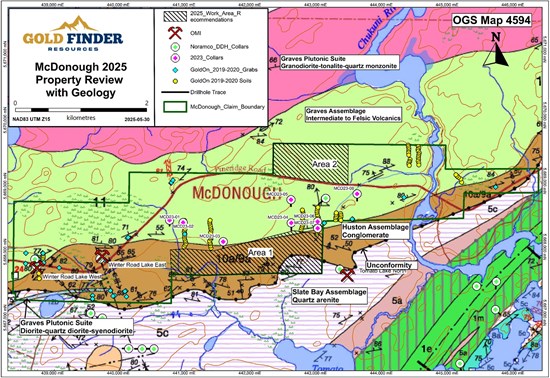
Figure 4: McDonough 2025 Property Review, Geology, and Area Recommendations
To view an enhanced version of this graphic, please visit:
https://goldfinderresources.com/images/McDonough/McDonough-2025-Review-with-Geology.jpg
Two areas were identified for follow-up geological mapping, prospecting and soil sampling.
The first is to the south of where 2023 drilling took place, towards a regional unconformity (Figure 4). Hole MCD23-04 intersected an intermediate intrusive rock over its final 71 meters, which is similar to the rock type hosting gold and silver mineralization in quartz veins at the Winter Road Lake West Occurrence in the western part of the property, which according to the Ontario Mineral Inventory (OMI) returned 0.435 g/t gold and 2.7 oz/ton silver over 2.13 meters in 1987 diamond drilling.
The second area of interest is north of where 2023 drilling took place, where 2019 field work identified further outcrops of intermediate intrusive rock which could be prospective for gold mineralization.
Gold Finder holds a 100% ownership interest in the McDonough property, which is located ~15 km north of the town of Red Lake, the 1,054-hectare property is contiguous with Evolution Mining's Slate Bay gold property and straddles a regional unconformity (see regional geology map) that is a key structural signature of many deposits within the Red Lake Greenstone Belt.
Coleman Robertson, P. Geo, a qualified person as defined in NI 43-101, has reviewed and approved the technical contents of this news release on behalf of the Company.
References:
Singh, 2005. Assessment Report on West Red Lake Properties for Redstar Gold Corporation, Red Lake District, NTS 52M01SE, 52M01SW, Ball Township, MNDM file 20000000647.
About Gold Finder Resources Ltd.
Gold Finder is a mineral exploration company focused on discovery-stage properties. Our goal is to add value by defining or redefining the exploration opportunity, maintain ownership control during the value creation phase of discovery, and then source a well-financed partner capable of accelerating discovery, resource definition, and development.
For more information, you can visit our website at goldfinderresources.com, download our investor presentation, and follow us on X at https://x.com/GoldFinderRes.
ON BEHALF OF THE BOARD
Signed "Gregory Lytle"
Gregory Lytle, President
Gold Finder Resources Ltd.
Direct line: (604) 839-6946
Email: info@goldfinderresources.com
179 - 2945 Jacklin Road, Suite 416
Victoria, BC, V9B 6J9
Forward-Looking Statements
This news release may contain "forward-looking statements" that involve known and unknown risks, uncertainties, assumptions, and other factors that may cause the actual results, performance, or achievements of the Company to be materially different from any future results, performance or achievements expressed or implied by the forward-looking statements. Any forward-looking statement speaks only as of the date of this news release and, except as may be required by applicable securities laws, the Company disclaims any intent or obligation to update any forward-looking statement, whether as a result of new information, future events, or results or otherwise.
Neither TSX Venture Exchange nor its Regulation Services Provider (as that term is defined in the policies of the TSX Venture Exchange) accept responsibility for the adequacy or accuracy of this release.
To view the source version of this press release, please visit https://www.newsfilecorp.com/release/264867
SOURCE: Gold Finder Resources Ltd.