Edmonton, Alberta--(Newsfile Corp. - April 8, 2026) - Canamera Energy Metals Corp. (CSE: EMET) (OTCQB: EMETF) (FSE: 4LF0) ("Canamera" or the "Company") is pleased to announce the completion of a 463.7 line-kilometre airborne magnetic survey over its Garrow rare earth element ("REE") project located in eastern Ontario, approximately 16 kilometres west of Timiskaming (the "Property"). The survey has identified a broad magnetic anomaly on the western portion of the Property that is spatially coincident with elevated total rare earth element ("TREE") values reported in regional lake sediment sampling conducted by the Ontario Geological Survey ("OGS").
The Garrow Project is an REE and niobium exploration property situated within the Grenville Province, a geological terrane known to host alkaline and carbonatite-related mineralization across eastern Ontario. The airborne survey represents the first modern geophysical dataset acquired over the Property and provides the Company with a foundational tool for targeting ground-level exploration programs. Garrow is one of three Ontario-based exploration assets in Canamera's portfolio, alongside the Schryburt Lake and Waterslide projects.
"The completion of the airborne magnetic survey at Garrow is an important step in advancing this early-stage asset," said Brad Brodeur, CEO of Canamera Energy Metals Corp. "The correlation between the broad magnetic anomaly and the elevated rare earth values in OGS lake sediment data gives us a well-defined target to pursue with ground-level work. This is exactly the kind of systematic, data-driven exploration approach that underpins our portfolio strategy across all jurisdictions."
Survey Overview
The airborne magnetic survey was conducted by Rosor Explorations and comprised 463.7 line-kilometres of data acquisition flown at 100-metre line spacing and an average flight height of 50 metres. The magnetic data obtained displays a strong correlation between magnetic response and the metamorphic and plutonic rock units underlying the Property, providing a clear representation of the general structural fabric and lithological trends (c.f. Figure 1).
Of particular significance is a broad magnetic high located on the western half of the Property and trending to the southeast (c.f. Figure 1). This magnetic high is interpreted to represent the extent of a gneissic granite mapped as Intermediate to Felsic Intrusive Rocks of the McDougal and Associated Plutons (circa 1250 Ma), as documented in published geological mapping by the Ontario Geological Survey1 (Easton, 2006).
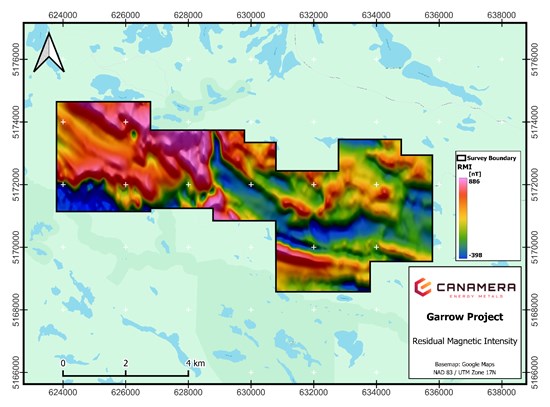
Figure 1 - Garrow Magnetic Survey
To view an enhanced version of this graphic, please visit:
https://images.newsfilecorp.com/files/11828/291596_c54e9de894e6fac5_001full.jpg
Regional Geochemical Correlation
Lake sediment geochemistry is a widely used regional-scale exploration tool in which the chemical composition of lake-bottom sediments serves as an indicator of the mineralogy of surrounding and upstream bedrock. In REE-prospective terranes, elevated rare earth concentrations in lake sediments can reflect the weathering and transport of REE-bearing minerals from proximal bedrock sources.
Coincident with the magnetic high is a series of lake sediment samples collected by the OGS in 2001 that yielded elevated TREE values (c.f. Figure 2). The convergence of two independent datasets - a geophysical anomaly defining a distinct lithological unit and a geochemical signature indicating elevated rare earth concentrations - strengthens the interpretation that the western portion of the Property warrants priority follow-up investigation.
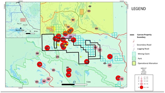
Figure 2 - Geophysics & Regional Sampling
To view an enhanced version of this graphic, please visit:
https://images.newsfilecorp.com/files/11828/291596_canafig204072026.jpg
Data in figure two represents results from the 2001 lake sediment regional geochemical survey MRD137, the information is sumarized from OGS Open File Report 6144
Next Steps
The Company will integrate the airborne magnetic data and its structural interpretations with the regional lake sediment geochemical dataset to delineate priority target areas for ground follow-up. Planned activities include geological mapping, prospecting, and soil geochemistry designed to further define the distribution of rare earth element mineralization and identify host lithologies on the Property. The Company expects to provide the market with an update on the ground program scope and timing in due course.
Qualified Person
The scientific and technical information in this news release has been reviewed and approved by Warren Robb, P.Geo. (British Columbia), VP Exploration of Canamera Energy Metals Corp. and a "Qualified Person" as defined by National Instrument 43-101 ("NI 43-101").
About Canamera Energy Metals Corp.
Canamera Energy Metals Corp. is a rare earth elements exploration and development company with an expanding project portfolio across Brazil, the United States, and Canada. The Company is focused on advancing ionic clay REE projects in Brazil and critical mineral assets in North America to support Western rare earth supply chain independence. For more information, visit www.canamerametals.com.
For Further Information Please Contact:
Brad Brodeur
Chief Executive Officer
brad@canamerametals.com
780-238-7163
CAUTIONARY NOTE REGARDING FORWARD-LOOKING INFORMATION
This news release contains forward-looking information within the meaning of applicable Canadian securities legislation. Forward-looking information in this release includes, but is not limited to, statements regarding: the Company's planned ground follow-up program at the Garrow Project, including geological mapping, prospecting, and soil geochemistry; the interpretation of airborne magnetic data and regional geochemical data as indicative of exploration potential; the Company's ability to delineate priority target areas for further investigation; and the Company's intention to provide further updates on program scope and timing. Forward-looking information is based on the opinions and estimates of management at the date the information is provided and is subject to a variety of risks and uncertainties and other factors that could cause actual events or results to differ materially from those projected. These factors include, but are not limited to: risks inherent in the exploration and development of mineral properties; the Company's ability to obtain required permits and regulatory approvals; uncertainties related to geological interpretations and the results of future exploration programs; changes in commodity prices and market conditions; the Company's ability to raise sufficient capital to fund planned exploration activities; and general economic and political conditions. The Company undertakes no obligation to update forward-looking information if circumstances or management's estimates or opinions should change, except as required by applicable securities laws. The reader is cautioned not to place undue reliance on forward-looking information.
Neither the Canadian Securities Exchange nor its Regulation Services Provider (as that term is defined in the policies of the Canadian Securities Exchange) accepts responsibility for the adequacy or accuracy of this release.
1 Easton, R.M. (2006). Precambrian geology, Jocko River area [Preliminary Map P.2846, scale 1:50,000]. Ontario Geological Survey. https://www.geologyontario.mines.gov.on.ca/persistent-linking?publication=P2846
![]()
To view the source version of this press release, please visit https://www.newsfilecorp.com/release/291596
Source: Canamera Energy Metals Corp.