Vancouver, British Columbia--(Newsfile Corp. - June 16, 2026) - Americas Uranium Corp. (CSE: NUCA) (OTC Pink: ASRFF) (FSE: WA7) (the "Company" or "Americas Uranium") is pleased to announce the advancement in its exploration strategy for the Ford Lake Uranium Project (the "Ford Lake Property") located on the south-eastern edge of the world-renowned Athabasca Basin, Saskatchewan. The Company has received a high-level property scale structural lineament analysis through combined regional, TDEM, and gravity geophysics to define high priority structural targets on the Ford Lake Property.
Ford Lake Project
The Ford Lake Property lies within the south-eastern edge of the uranium producing Athabasca Basin. It is located approximately 15 km northwest of the currently operating Key Lake uranium mill, and 580 km north-northeast of Saskatoon, Saskatchewan. The Ford Lake Property resides near the transition zone between the Wollaston and Mudjatik domains which are host to several major unconformity and basement hosted uranium deposits.
The Company advises that, notwithstanding their proximity and location, discoveries of minerals on or near historic mines such as the Key Lake Mine site or the deposits at the Wollaston and Mudjatik domains, and any promising results thereof, are not necessarily indicative of the mineralization of, or located on the Ford Lake Property, or the Company's ability to commercially exploit the Ford Lake Property, or to locate any commercially exploitable deposits therefrom. The Company cautions investors on relying on this information as the Company has not confirmed the accuracy or reliability of the information.
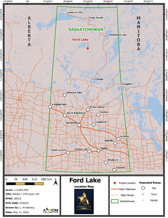
Figure 1: Location of the Ford Lake Property
To view an enhanced version of this graphic, please visit:
https://images.newsfilecorp.com/files/12293/301722_2e34e351f4118bea_001full.jpg
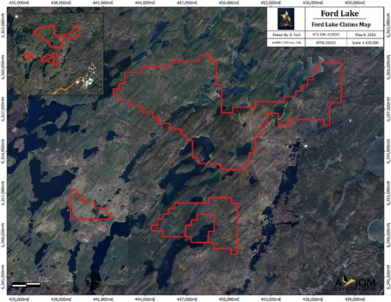
Figure 2: Ford Lake Property Mineral Dispositions
To view an enhanced version of this graphic, please visit:
https://images.newsfilecorp.com/files/12293/301722_2e34e351f4118bea_002full.jpg
2026 Property Scale Structural Lineament Analysis
Regional Structural Interpretation and Exploration Significance
A regional structural interpretation was undertaken to identify and characterize the principal structural features within the Ford Lake area. Structural elements were delineated using a combination of topographic, geophysical, and geological datasets. Particular emphasis was placed on mapping lineaments, faults, fractures, and other structural discontinuities that potentially influence mineralizing fluid migration and subsequent uranium deposition.
Structural Complexity Assessment Methodology
To evaluate the spatial distribution, density, and connectivity of these features across the project area, all interpreted lineaments were compiled into a single, integrated structural dataset. Structural complexity was then quantified by intersecting this comprehensive lineament network with a standardized analysis grid, calculating the total abundance and distribution of structural features within each individual grid cell. Zones exhibiting a higher concentration of lineaments may indicate elevated structural complexity and enhanced network connectivity. In the context of uranium exploration, these high-density sectors typically reflect zones of increased bedrock permeability and secondary porosity, which serve as primary pathways for hydrothermal fluid flow.
Advanced Analytics and Regional Trends
To refine the dataset, focal statistical analysis was applied to the structural surfaces. This spatial smoothing technique effectively filters out local-scale variability and high-frequency "noise," successfully isolating distinct clusters of elevated complexity. This analytical approach highlighted areas where structural features converge, intersect, or coalesce into broader, regional-scale structural corridors, providing critical insight into the regional controls on mineralization.
Results
Regional Lineament Analysis
Structural analysis across the project area identified an interconnected network of four distinct lineament classes, ranging from prominent, laterally continuous first-order regional corridors to abundant, lower-order subsidiary and minor features that define the overarching structural fabric. Regionally, this network is dominated by northeast-southwest and northwest-southeast trends, with the highest-order corridors strongly anchoring the primary northeast-southwest structural trajectory. The Ford Lake Property closely mirrors this regional architecture, exhibiting a dominant northeast-southwest structural grain driven by its most continuous first- and second-order corridors. While secondary northwest-southeast and east-northeast-west-southwest trends introduce localized complexity, comparison with the broader dataset confirms that Ford Lake's principal structural corridors are not isolated anomalies, but are direct local expressions of a highly continuous, regional-scale structural system.
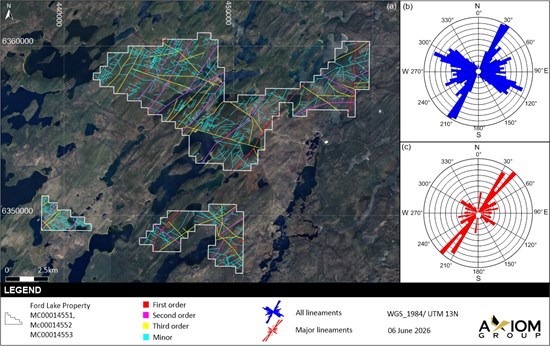
Figure 3: Lineament analysis results showing First, Second, and Third order structures across the Ford Lake Property
To view an enhanced version of this graphic, please visit:
https://images.newsfilecorp.com/files/12293/301722_2e34e351f4118bea_003full.jpg
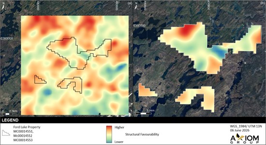
Figure 4: Structural favourability model for The Ford Lake Property derived from the weighted integration of structural complexity, structural complexity gradient, lineament density, lineament intersections, hydrothermal alteration and aeromagnetic first vertical derivative (FVD) datasets.
To view an enhanced version of this graphic, please visit:
https://images.newsfilecorp.com/files/12293/301722_2e34e351f4118bea_004full.jpg
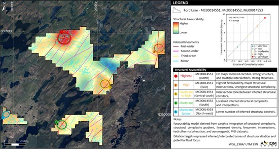
Figure 5: Structural favourability model showing identified areas of structural interest within The Ford Lake Property and the relationship between structural complexity index and lineament intersection density.
To view an enhanced version of this graphic, please visit:
https://images.newsfilecorp.com/files/12293/301722_2e34e351f4118bea_005full.jpg
Exploration Targeting and Next Steps
The resulting Structural Complexity Model represents a powerful, data-driven exploration targeting tool to identify structurally favorable areas for follow-up investigation. Sectors characterized by coincident high lineament density, enhanced structural connectivity, and elevated complexity are interpreted as optimal pathways for mineralizing fluids and prospective sites for uranium deposition. These modeled trends will be used to systematically prioritize upcoming exploration activities, choose drilling target areas, and optimize the design of future geological, geochemical, and geophysical programs.
Nick Luksha, CEO of Americas Uranium Corp., commented:
"The application of structural analysis to these claims will play an important role in the planning, prioritization, and execution of drill targets on the Ford Lake Property. Reactivated structural corridors are proven pathways for uranium-bearing fluids, and we're excited to test these targets with drilling."
Cautionary Statement
Disclaimer:
It is important to recognize that structural interpretation and complexity analysis are predictive in nature and are derived primarily from remotely interpreted datasets. Consequently, the results do not constitute direct evidence of mineralization and should be regarded as a screening and targeting tool only. All interpreted structures, structural corridors and prospective target areas must be validated through field verification and integrated with geological mapping, geochemical sampling, geophysical surveys and, where appropriate, drilling data before any conclusions regarding mineral potential or exploration significance can be made.
Quality Control
The desktop interpretation was based on the integration of available geophysical data, regional geological information, remote sensing-derived hydrothermal alteration mapping, and structural lineament analyses. Quality control measures included review of the input datasets, verification of spatial consistency, and technical review of the integrated interpretation. As with all desktop interpretations, the results are subject to interpretive uncertainty and should be regarded as conceptual until verified through appropriate field investigations.
Qualifying Statement
The scientific and technical information in this news release has been reviewed and approved by Troy Marfleet, P.Geo., Technical Advisor for Americas Uranium Corp., a registered member of the Professional Engineers and Geoscientists of Saskatchewan. Mr. Marfleet is a Qualified Person as defined by National Instrument 43-101.
About Americas Uranium Corp.:
Americas Uranium Corp. is a Canadian mineral exploration company focused on the discovery and development of high-potential uranium assets. The company holds a portfolio of 10,872.88 hectares of strategically located properties in Saskatchewan's Athabasca Basin, one of the world's premier uranium districts. Americas Uranium is advancing early-stage exploration through modern techniques and a disciplined, data-driven approach. The Company is committed to building long-term value through responsible exploration and a focus on high-impact targets in underexplored areas.
For further information, please contact:
Attention: Nicholas Luksha, CEO
Americas Uranium Corporation
Phone: (604) 838-0184
Neither the CSE nor the Market Regulator (as that term is defined in the policies of the CSE) accepts responsibility for the adequacy or accuracy of this release.
This news release includes certain statements and information that may constitute forward-looking information within the meaning of applicable Canadian securities laws. Forward-looking statements relate to future events or future performance and reflect the expectations or beliefs of management of the Company regarding future events. Generally, forward-looking statements and information can be identified by the use of forward-looking terminology such as "intends", "believes" or "anticipates", or variations of such words and phrases or statements that certain actions, events or results "may", "could", "should", "would" or "occur". This information and these statements, referred to herein as "forward-looking statements", are not historical facts, are made as of the date of this news release and include without limitation, statements regarding discussions of future plans, estimates and forecasts and statements as to management's expectations and intentions with respect to, among other things, the future potential of the mineral claims held by the Company and the usefulness of the results from the current exploration work to choose drilling target areas, and optimize the design of future geological, geochemical, and geophysical programs. In making the forward-looking statements in this news release, the Company has applied several material assumptions, including without limitation the assumption that the Company will be able to continue exploring its properties given various environmental and economic factors outside of its control and that the Company will be able to obtain its intended results from the exploration on the Ford Lake Property. Although management of the Company has attempted to identify important factors that could cause actual results to differ materially from those contained in forward-looking statements or forward-looking information, there may be other factors that cause results not to be as anticipated, estimated or intended. There can be no assurance that such statements will prove to be accurate, as actual results and future events could differ materially from those anticipated in such statements. Accordingly, readers should not place undue reliance on forward-looking statements and forward-looking information. Readers are cautioned that reliance on such information may not be appropriate for other purposes.
The Company does not undertake to update any forward-looking statement, forward-looking information or financial out-look that are incorporated by reference herein, except in accordance with applicable securities laws.
To view the source version of this press release, please visit https://www.newsfilecorp.com/release/301722
Source: Americas Uranium Corp.